Larkhill Road
Larkhill Road
The former Down Lane, on the line of a Roman road
In Roman times a subsidiary road ran from Ilchester (Lindinis) to Dorchester (Durnovaria) leaving Ilchester on the line of the present A37 and then passing through present day Yeovil (shown on the map here), on a route that took in today's Larkhill Road, crossing the eastern end of Westlands airfield and passing close to Rustywell then continuing along the A37 Dorchester Road south of the town.
The Romans were very active in the area of today's Larkhill Road and left evidence -
-
Some Roman coins were found on the Roman road which ran along the line of today's Larkhill Road. The coins were exhibited at a meeting of the Somerset Archaeological Society in Yeovil in September 1853.
-
Later, portions of four Romano-British pots were found in 1901 and 1903 by Walter Raymond, in a field adjoining the Roman road at Larkhill Road.
-
A group of coarse pottery and a coin of Constantine II, Roman Emperor from 337 to 340 AD, was discovered near Larkhill Road in the 1920's.
-
Between Freedom Avenue and Burroughs Avenue, about 400m from the Roman Road near the Larkhill quarry site, workmen discovered a human burial containing a coin of Constantine I in the skull while digging an electricity cable trench in 1949. It is believed that the coin was placed in the mouth of the deceased so that he could pay Charon the ferryman to take him across the River Styx on his journey to the Underworld. Constantine I was Roman Emperor from 306 to 337 AD.
In more recent times no trace of the former Roman road, other than the alignment, existed and it reverted to a minor country lane. It was known, certainly as late as the 1841 census, as Down Lane although beyond the Thorne Lane crossroads it was known as Ashley Lane. It was also recorded as Down Lane in the 1864 Valuation List.
Throughout the latter part of the nineteenth century and well into the twentieth (in fact after the Second World War) it became known as Larkhill Lane. There were also two other lanes with similar names although these were little more than field access tracks originally running from Ilchester Road and not joining Larkhill Lane until the twentieth century. These were Higher Larkhill Lane (still named as such in the 1950s), which would eventually become Boundary Close, and Lower Larkhill Lane that by the 1950s had become Stiby Road.
Larkhill Lane / Road marked the boundary of the Borough of Yeovil until 1928 when the village of Preston Plucknett was absorbed.
Until relatively recent times there existed a small quarry off the eastern side of Larkhill Lane, roughly where the southern end of Freedom Avenue (built by 1952) stands today. At its centre was a lime kiln which was still being shown on the Ordnance Survey map of 1928.
After the Second World War Britain had a major housing shortage. In a radical solution, the government built thousands of prefabricated homes or 'prefabs', especially in London and other large cities, as a temporary replacement for housing that had been destroyed by bombs. About 150 were built in Larkhill Road during a six-week period in late 1946. At this time, apart from the post-1903 houses at the very southern end of Larkhill Road, only two other houses existed along the road.
The southern half of today's Larkhill Road was not made up to modern road standards until 1946, with the building of the 'prefabs'. The road construction work being carried out chiefly by Italian prisoners of war - somewhat ironic for a former Roman road! The northern half was not made up until the early 1950s with the construction of housing, especially on the eastern side of the road.
maps & Aerial photographs
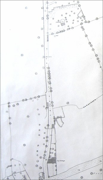
This map, based on the 1886 Ordnance Survey, shows the southern section of Larkhill Lane with just one house - Ivy Cottage. Other houses would not be built in Larkhill Lane until after 1903. The area at the top, east of the lane was the Larkhill Quarry. The small building at its centre was a lime kiln which was still being shown on the Ordnance Survey map of 1928 (below).
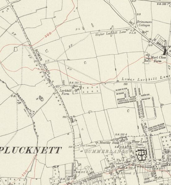
An extract from the 1928 Ordnance Survey showing the full length of the road that was still called Larkhill Lane, from Preston Road at centre bottom to the Thorne Lane crossroads at top left. Note the field access tracks called Higher Larkhill Lane (in the top right quadrant) and Lower Larkhill Lane (at centre right). Note too the 'Old Limekiln' towards centre bottom.
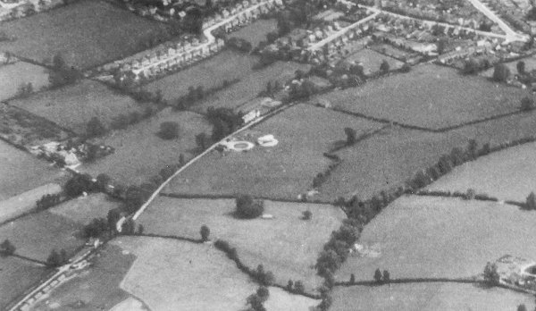
An aerial photograph of 1941 showing Larkhill Lane running from its junction with Preston Road at top right, down past Larkhill Farm at centre left. At centre, the circular object is Yeovil's Barrage Balloon Site No 19, "Larkhill Lane". There are no traces of any structures on the RAF vertical air photographs of 1946, but it is quite clear on this 1941 photograph.
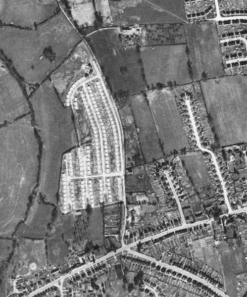
This 1946 aerial photograph clearly shows the development of prefabs in Larkhill Road, at this time little more than a track. Much of Larkhill Road would be built in 1946 by Italian prisoners of war. Running across the bottom of the photograph is Preston Road and from the junction with Larkhill Road and running to the bottom right corner is Preston Grove.
The curve in the road at the top of the prefabs development is where Abbey Road runs today. To the right of Larkhill Road is Home Drive and Cedar Grove, albeit without Burroughs Avenue.
gallery
This
colourised photograph
features in my
book 'Yeovil From Old Photographs'.
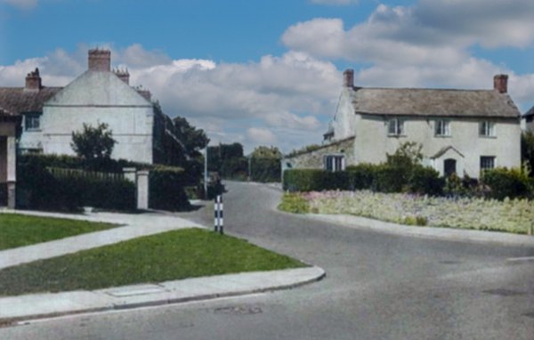
The southern end of Larkhill Road seen from Preston Road, probably photographed in the 1950s. At right is Ivy Cottage (later re-named Laurel House) which is shown on the 1886 Ordnance Survey above (indeed, it was also shown on the 1842 Tithe Map) as the only house. It was demolished in the 1960s. The Larkhill Road houses at left (built in 1906) were actually in the parish of Preston Plucknett until the 1928 boundary changes.
Courtesy of Jack
Sweet
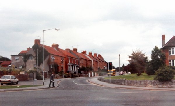
Pretty much the same view in 1993.
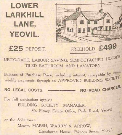
An advertisement for new houses in Lower Larkhill Lane for £499 freehold! from the 1 May 1936 edition of the Western Gazette.
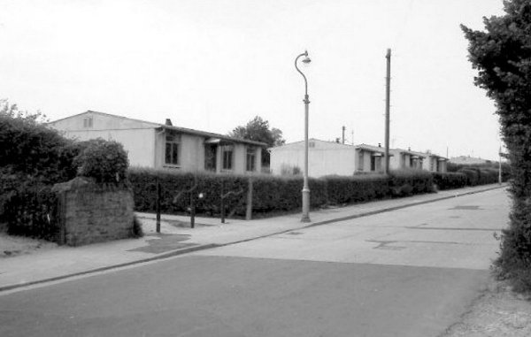
The 'prefabs' in Larkhill Road. The road was constructed to modern standards (of the day) by Italian prisoners of war at the same time as the prefabs were built in 1946.
Courtesy of Jack
Sweet
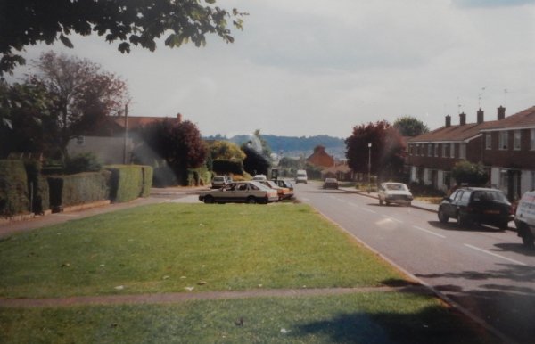
Larkhill Road, looking south. The wide grass verges that run alongside the road were reserved for a proposed Yeovil Relief Road, designed in 1935 but not implemented. Photographed in 1993.
Courtesy of Jack
Sweet
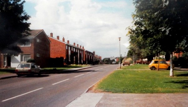
Larkhill Road, looking north.