Lower Stone farm
Lower Stone farm
A small, mostly arable, farm
In earlier times, certainly by the sixteenth century, Lower Stone Farm was built in the eastern central part of the field known as Stoney Field and it was probably at this time that Stoney Field was subdivided into Parcels 1087 and 1888. Green Cross (1080) to the immediate south was most likely part of the original field and was also partitioned off at the same time. It was bounded by Higher Elm Path (1094) and Middle Elm Path (1086) to the west, Combe Street (1093 and 1092) to the north, Hutt Field (1089) to the northeast and Mudford Road to the east.
The 1846 Tithe Apportionment recorded that Lower Stone Farm was owned by Henry Goodford of Chilton Cantelo and the tenant was John Newman Berkley.
On 30 August 1849 Henry Goodford leased to baker Nathaniel Bartlett of Yeovil, the following parcels of land, "Land late in occupation of Mr John Newman-Birkley in Yeovil" for £172 10s 0d (around £200,000 at today's value) -
-
a cottage and garden Hundred Acres - 3a 2r 20p
-
Stoney Field and Green Close - 8a 2r 10p
-
Higher Elm Path - 7a 2r 12p
-
Middle Elm Path - 8a 3r 35p
-
Lower Elm Path - 7a 1r 20p
-
Coombe Street - 5a 2r 10p
-
Beacon - 16a 2r 10p
-
Total - 58a 1r 26p
Several later tenants of Lower Stone Farm are know -
1879 - Dowding
1932 - Haddon
1933 - G H Lock
of Lock & Son,
Seedsmen of
Yeovil
1941 - Luckham
1944 - F Winsor
1949 - EF
Goodrich
Early in 1963 Lower Stone Farm, the farm to the Combe Street Lane and Chilton Grove/Mudford Road sides of Mudford Road Playing Fields was bought. The Council had long wanted at least part of the land to extend MRPF, had refused planning permission for housing and were going to compulsory purchase. Eventually they paid the price of building land for the farm. The Chilton Grove car park was built on the farmhouse and farmyard land, soil excavated during the athletics arena construction was transferred to the field off Combe Street Lane, a pitch and putt course built on the land between Combe Street Lane and the farmhouse and a large pond on the triangle of land behind houses in Mudford Road filled in. In 1970 the pitch and putt opened and the following year Mudford Road Playing Fields were renamed Yeovil Recreation Centre.
Today much of the former Lower Stone Farm is occupied by Yeovil Recreation Centre.
For details on historic land measurement (ie acres, roods and perches) click here.
map

This map, based on the descriptions in the 1589 Terrier and the 1846 Tithe Map of Yeovil shows the approximate boundaries of the Manors of Kingston and Hendford as well as the manorial three-field system used in Kingston.
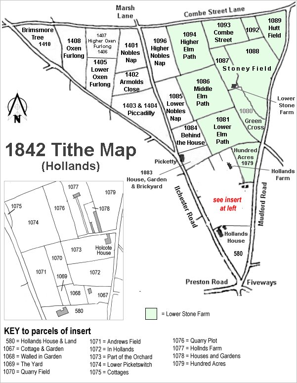
The Hollands area reproduced from the 1842 Tithe Map.
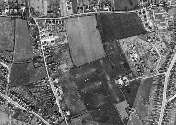
The 1946 aerial photograph showing Lower Stone Farm left of centre, with its access track (today's Chilton Grove) leading off to Mudford Road at the right.
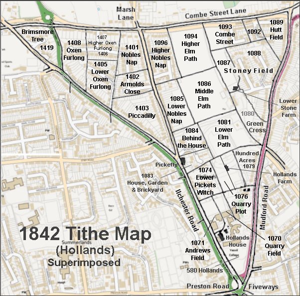
The 1842 Tithe Map superimposed over a modern map.