Plantations 1 & 2
Plantations 1 & 2
A part of Preston Lower farm
Plantation 1 (Parcel 145a) and Plantation 2 (Parcel 146a) were both parts of Preston Lower Farm. Both were in the very southeastern corner of the farm
The 1848 Preston Tithe Apportionment noted that both plantations were owned and occupied by Robert Tucker. Plantation 1 (Parcel 145a) was described as 'Meadow & Plantation' measuring just 0a 0r 30p, while Plantation 2 (Parcel 146a) was described as 'Pasture & Plantation and measured 0a 1r 34p.
Plantation 1, the southern of the two, lay at the confluence of two brooks - one feeding Dodham Brook and coming from the direction of Watercombe in the west, the other rising near Preston Road to the north and flowing south behind the gardens on the east of Grove Avenue and being the former parish boundary between Yeovil to the east and Preston Plucknett to the west. This is the brook that today is seen running along the eastern side of West Street. To the west Plantation 1 was bounded by Three Acre Mead (Parcel 145) and to the north by Plantation 2. Today Plantation 1 is covered by the garden of a house in Preston Grove.
Plantation 2 lay to the north of Plantation 1 and again ran alongside the boundary brook. To the west it was bounded by Little Bucks Mead (Parcel 146) and to the north by Catshill Eight Acres (Parcel 147). Today Plantation 2 is covered by The Lodge and its garden at the south and by the rear gardens of the houses on the eastern side of Grove Avenue.
For details on historic land measurement (ie acres, roods and perches) click here.
MAPS & Aerial Photographs
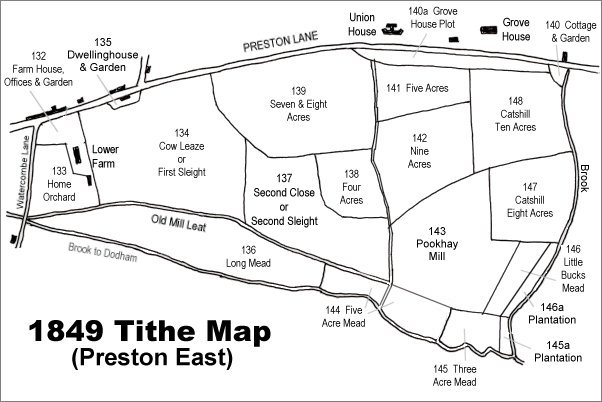
The 1849 Preston Tithe Map. Both plantations are at bottom right.
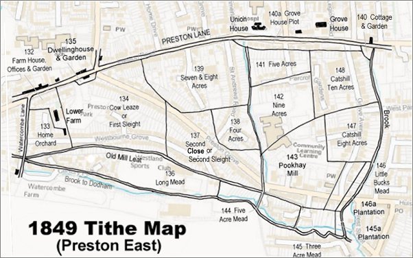
The 1849 Preston Tithe Map overlaid on a modern map (the 1849 map is slightly incorrect at bottom right).
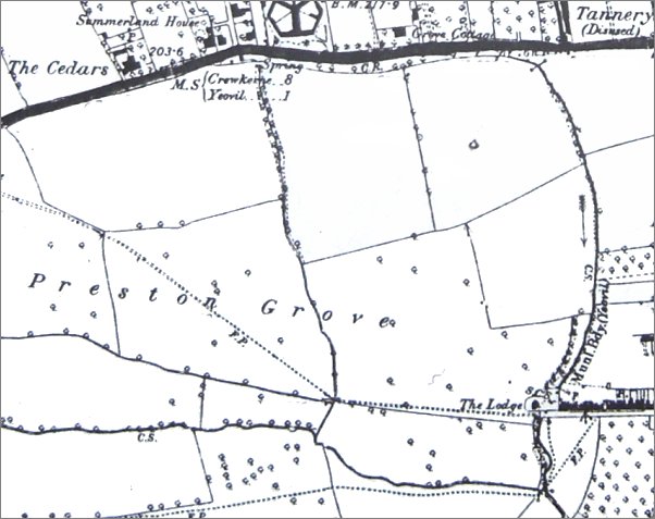
The 1889 Ordnance Survey shows the extensive fields of Lower Farm labelled 'Preston Grove' stretching eastwards. The dotted line across the fields, indicating a footpath, was the line of the later road, also called Preston Grove. The boundary brook is seen flowing down the right of the map; both plantations ran alongside the brook - Plantation 1 to the south of 'The Lodge' and Plantation 2 to the north.