yeovil at war
WW2 emergency water tank sites
Somerset Fire Service and the Auxiliary Fire Service
By the beginning of the war ‘portable dams’, which held 1,000 gallons of water and were placed on open ground, were ready to be moved into threatened areas. These were supplemented later by larger steel structures that held up to 22,500 gallons, or more often 11,500 gallons, sited in strategic locations and kept full with water which was changed every month or so to avoid it becoming stagnant. In the event, both of these types of structure were of limited use as they were not large enough to provide water for more than a few minutes, being intended only as an immediate supply.
Ten emergency water tank sites are known for Yeovil; one large 22,500 gallon circular steel dam type tank in Bide's Gardens and the rest smaller 11,500 gallon versions. Most static water tanks were removed immediately after the war as they were a health hazard, dangerous to children and misused as rubbish dumps.
|
Yeovilians
remember... The local fire department had vans with trailers upon which were mounted pumping units. These units would pump the water from the big concrete cisterns and take it to where it was needed. The water got very stagnant and netting had to be installed to stop rubbish being thrown into the containers. The local citizens knew where the water pipes were in the dark and knew when to step over them. However, occasionally there was a metal clang from a British army boot followed by a good British curse in some strange dialect. Later when the US forces were here, it would be a thud followed by a strange curse emanating from the hinterland of the USA."
Memories
of the
late
Walter
McGowan |
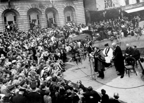
Mayor Vosper address the crowd in the Borough from a platform erected on an emergency water tank on the site of the bombed Medical Hall. VE Day, 8 May 1945.
![]()
The following aerial photographs are from the Somerset County Council's Historic Environment Record and were all taking in late 1945 or early 1946.
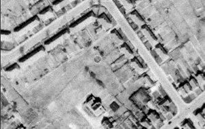
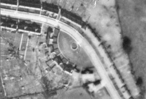
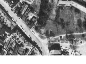 At
centre
is a
circular
emergency
water
supply
tank
about
12m in
diameter
on what
used to
be the
southwest
corner
of
Byde's
Gardens.
It is a
22,500
gallon
'circular
steel
dam',
4ft deep
and 17ft
1in
radius
built on
a
concrete
base.
This
larger
tank is
indicative
of the
importance
of the
adjacent
area and
the
quantity
of water
likely
to be
needed
for fire
fighting
during
an air
raid.
At
centre
is a
circular
emergency
water
supply
tank
about
12m in
diameter
on what
used to
be the
southwest
corner
of
Byde's
Gardens.
It is a
22,500
gallon
'circular
steel
dam',
4ft deep
and 17ft
1in
radius
built on
a
concrete
base.
This
larger
tank is
indicative
of the
importance
of the
adjacent
area and
the
quantity
of water
likely
to be
needed
for fire
fighting
during
an air
raid.
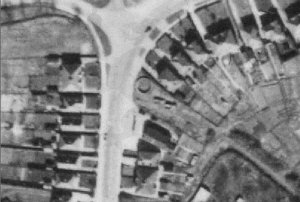
 At
centre
of this
photograph
is an
11,500 gallon
circular
emergency
water
tank, 7m
in
diameter,
and
located
at the
junction
of
Preston
Grove
(running
diagonally
from top
left to
bottom
right)
and Westborne
Grove.
The
location
of the
feature
in a
housing
area and
close to
the
boundary
of
Westland
Airfield.
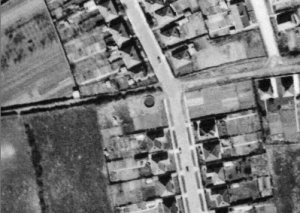
At
centre
of this
photograph
is an
11,500 gallon
circular
emergency
water
tank, 7m
in
diameter,
and
located
at the
junction
of
Preston
Grove
(running
diagonally
from top
left to
bottom
right)
and Westborne
Grove.
The
location
of the
feature
in a
housing
area and
close to
the
boundary
of
Westland
Airfield.
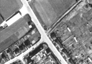
 At
centre is a
circular Second
World War
emergency water
tank, on the
south side of
West Coker Road
(running across
the photograph)
at the right of
the junction
with Beaconfield
Road. It was a
7m, 11,500
gallon version.
At
centre is a
circular Second
World War
emergency water
tank, on the
south side of
West Coker Road
(running across
the photograph)
at the right of
the junction
with Beaconfield
Road. It was a
7m, 11,500
gallon version.
 At
centre of this
photograph is an
11,500 gallon
circular
emergency water
tank, 7m in
diameter. It is
off Sandhurst
Road (running
vertically
across the
centre of the
photograph) and the
hedgerow running
across the
photograph to
the left is the
site of today's Arnewood
Gardens.
At
centre of this
photograph is an
11,500 gallon
circular
emergency water
tank, 7m in
diameter. It is
off Sandhurst
Road (running
vertically
across the
centre of the
photograph) and the
hedgerow running
across the
photograph to
the left is the
site of today's Arnewood
Gardens.
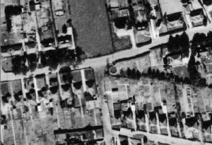
 At
centre of this
aerial photograph is an
11,500 gallon
circular
emergency water
tank, 7m in
diameter. It is
located on the
east side of The
Park, in the
northwest corner
of
Sidney
Gardens.
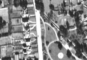
At
centre of this
aerial photograph is an
11,500 gallon
circular
emergency water
tank, 7m in
diameter. It is
located on the
east side of The
Park, in the
northwest corner
of
Sidney
Gardens.
The white circular feature towards bottom right is the fountain.
 This
is another
11,500 gallon
circular
emergency water
tank, 7m in
diameter, to the
west of
Hillcrest Road
(running from
top centre to
bottom right).
This
is another
11,500 gallon
circular
emergency water
tank, 7m in
diameter, to the
west of
Hillcrest Road
(running from
top centre to
bottom right).
At bottom right is Grass Royal and at top left is Fielding Road.
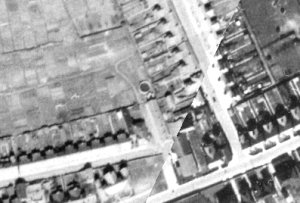 At
centre of this
photograph is an
11,500 gallon
circular
emergency water
tank, 7m in
diameter. It was
located in the
allotment
gardens to the
immediate north
of the Royal
Marine.
At
centre of this
photograph is an
11,500 gallon
circular
emergency water
tank, 7m in
diameter. It was
located in the
allotment
gardens to the
immediate north
of the Royal
Marine.
The diagonal
split in the
photo is the
join of two
photos. At lower
left is Great
Western Terrace
and to the right
is Cromwell
Road.
 At
centre of this
aerial
photograph is an
11,500 gallon
circular
emergency water
tank, 7m in
diameter. It is
located at the
bend in the
eastern half of
Rosebery Avenue.
At
centre of this
aerial
photograph is an
11,500 gallon
circular
emergency water
tank, 7m in
diameter. It is
located at the
bend in the
eastern half of
Rosebery Avenue.
 This
is another
11,500 gallon
circular
emergency water
tank, 7m in
diameter. It was
situated on the
east side of
Goldcroft which
running from top
left to bottom
right.
This
is another
11,500 gallon
circular
emergency water
tank, 7m in
diameter. It was
situated on the
east side of
Goldcroft which
running from top
left to bottom
right.
Running to bottom left is Sparrow Road and the track leading to top right would later become Milford Road.
 At
left of centre of this
photograph is an
11,500 gallon
circular
emergency water
tank, 7m in
diameter, and
located in a
Borough Council
yard behind
13-17 Vicarage
Street.
At
left of centre of this
photograph is an
11,500 gallon
circular
emergency water
tank, 7m in
diameter, and
located in a
Borough Council
yard behind
13-17 Vicarage
Street.
Running left to right across the lower half of the photograph and dropping down to the bottom right corner is Vicarage Street and the road running vertically from it in the right of the photo is Vincent Street.
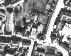
 At
the centre of
this photograph
is an 11,500
gallon circular
emergency water
tank, 7m in
diameter, on the
bend in Mudford
Road close to
Hundredstone
Corner. Just
below and to the
right is the
Auxilliary Fire
Service's Fire
Station.
At
the centre of
this photograph
is an 11,500
gallon circular
emergency water
tank, 7m in
diameter, on the
bend in Mudford
Road close to
Hundredstone
Corner. Just
below and to the
right is the
Auxilliary Fire
Service's Fire
Station.