Tithe Maps and Apportionments
Tithes, Maps and APPortionments
Landowners and Occupiers of 1840s Yeovil
-
The Origins
of Tithe
-
The Tithe
Commutation
Act of 1836
-
Tithe Maps
and
Apportionments
-
Yeovil
listed by
Land Owners
-
Yeovil
listed by
Land
Occupiers
-
Yeovil
listed by
Parcel
Number
-
Preston
Plucknett
listed by
Land Owners
-
Preston
Plucknett
listed by
Land
Occupiers
-
Preston
Plucknett
listed by
Parcel
Number
For an explanation of Historic Land Measurement - click here.
The Origins of Tithes
The tithe was an
annual payment
of an agreed
proportion
(originally
one-tenth) of
the yearly
produce of the
land, which was
payable by
parishioners to
the parish
church, to
support it and
its clergyman.
Originally
tithes were paid
‘in kind’ (wool,
milk, honey,
fish, barley and
so on) and were
payable on three
categories of
produce:
-
All things which grew and which increased annually e.g. grain, vegetables and wood.
-
All things which were nourished by the ground such as lambs, calves, etc. and also animal produce such as milk, hides, eggs and wool.
-
The produce of man’s labour, particularly the profits of mills and fishing.
Tithes were
also classed as
being great or
small.
Great
tithes
were derived
from corn, other
grains, hay and
wood. These
tithes were
commonly payable
to the Rector of
a parish and
were therefore
also called
'rectorial'
tithes. The
1589 Terrier
occasionally
specifically
refers to "the
Tithes of Corn
and Hay".
Rectors were
often remote
from the
parishes, so a
deputy or Vicar
was appointed to
act as the
parish priest.
Because the
Vicar was not
entitled to the
great tithe, it
was usual to
provide him with
the small tithes
(worth about a
third of the
total tithe of
the parish) as a
basis for a
living.
Small
tithes
were derived
from all other
things that
grow, such as
vegetables,
fruit, hops;
also animals and
animal produce,
as well as
milling and
fishing profits.
These were all
commonly payable
to the Vicar of
the parish and
therefore also
called 'vicarial'
tithes.
The difference
in income
between the
Rector and the
Vicar could be
considerable,
with the bulk of
the tithe income
often going to
an absentee
Rector. Some
Vicars did their
utmost to
increase their
income by making
such produce as
acorns or fallen
apples tithable.
At the
Dissolution of
the Monasteries,
many of the
great tithes
passed into the
hands of laymen,
who became the
new owners of
the church land
and its
accompanying
rectorial
tithes. The
payment of tithe
was a cause of
endless dispute
between the
tithe owners and
the tithe
payers. In
addition,
Quakers and
other
Non-Conformists
objected to
paying any
tithes to
support the
established
church. Almost
every
agricultural
process and
product
attracted
controversy over
its tithe value.
By the
eighteenth
century the
complex
legislation
surrounding the
tithe began to
have a
detrimental
effect on the
increasing
numbers of
farmers working
for agricultural
improvement.
Tithing was seen
as increasingly
irrelevant to
the needs of the
community and
the developing
agricultural
industry.
A land terrier is a record system for an institution's land and property holdings, in the case of Yeovil the Terrier of 1589, known at the time as a 'View of the Parsonage of Yeovil and Pitney' was compiled for the Church's holdings. The word 'terrier' derives from the Latin terra, meaning land.
The Tithe Commutation Act of 1836
From early times, money payments had begun to be substituted for payments in kind. By 1836 tithes were still payable in most of the parishes in England and Wales, but the Government had decided on the commutation of tithes. In other words, the substitution of money payments for payment ‘in kind’ was to be introduced across the country. As a consequence the Tithe Commutation Act was passed in 1836. Three Tithe Commissioners were appointed and the long process of commutation began, with Assistant Commissioners stationed around the country to oversee implementation of the Act. These money payments were not to be subject to local variation. The Act proposed a fluctuating money payment adjusted each year and based on the average price of wheat, barley, and oats.
It was hoped that an annual review of the payment for each tithe owner would reflect the variable nature of the amount of farm produce in good and bad harvests, and preserve the purchasing power of the payment. Every piece of land subject to tithe was to have a monetary value assigned to it and a record was to be kept so that a prospective purchaser of land would know exactly what he would have to pay annually to the tithe owner. In this way the value of a piece of land could be measured against its tithe obligation.
Tithe Maps
and
Apportionments
A survey of the
whole of England
and Wales was
therefore
necessary.
Enquiries were
sent to every
parish and
township listed
in the census
returns, and
meetings took
place all over
the country to
find out how
much commutation
had already
taken place. The
Commissioners
then established
Tithe Districts
to distinguish
them from
parishes. Most
Tithe Districts
corresponded
with parishes,
but the
Commissioners
could, if
necessary, form
separate
districts. Many
parish
boundaries came
under close
scrutiny,
perhaps for the
first time in
centuries, and
maps showing
these were drawn
up. We now call
these tithe
maps. This huge
effort to survey
the country in
the 1840s gives
us the first
detailed view of
the rural
landscape of
England and
Wales. The
Yeovil Tithe Map
was surveyed and
drawn up in 1842
by local
surveyor and
cartographer
Edward
Bullock
Watts, who had
been producing
local maps since
at least 1806.
The tithe maps and apportionments are an important source of information about the history and topography of the parish. They provide details of land ownership and occupation, and the type of cultivation of the land, and are often the earliest complete maps of parishes. They were produced in order to assess the tithe payable in cash to the parish church for the support of the church and its clergy. This tithe had been paid in kind until The Commutation Act was passed in 1836, when it was agreed that this should be converted to a monetary payment.
A survey of the whole of England and Wales was undertaken in the decade or so after 1836, to establish the boundaries of each parish, and assess the amount of tithe due for each parcel of land within it. This resulted in the survey of all titheable land in each parish, the production of a map covering the whole parish and a reference book (apportionment) identifying each plot of land. Yeovil's Tithe Apportionment was ready by 1846.
map
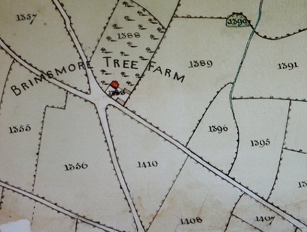
Part of the 1842 Tithe Map showing the fields around Brimsmore Tree Farm. Each field was numbered and the corresponding number entered in the Tithe Apportionment together with the details such as Owner, Occupier, acreage, use and tithe amount. For example, Parcel 1356 at lower left was a pasture called Lockyer's Ground, its area was 9a 1r 9p, it was owned by John Winter and occupied by Joseph Brooks.
The original map was coloured with pale watercolour washes. Sadly the Tithe Apportionment does not list all the properties.