Yeovil at war
zeppelins over yeovil
Aerial Reconnaissance in preparation for the Second World War
Many older Yeovilians remember a Zeppelin flying over Yeovil in 1939, but few knew what it was doing overhead. According to the Western Gazette this was not the first occasion Yeovil had been visited by a Zeppelin "There, over the rooftops, floating through a clear blue sky at about 1,000ft, was a long, silver, cigar-shaped object - the Graf Zeppelin.... the airship changed direction and headed for the Westland Aircraft premises, where it hovered for a good quarter of an hour. The crew of the airship busied themselves taking photographs - a matter that aroused curiosity rather than alarm. The date was 3 July 1932, and none of the onlookers dreamed that the Germans were gathering information about English military targets in preparation for war."
|
Yeovilians remember... Many thanks to Margaret O'Shea (whose grandparents Cecil and Mary Davis ran the Hollands Inn from 1926 to 1934) for the following - "I have a letter that my grandfather wrote from Hollands Inn in which he says that during one afternoon his elder daughter Linda came rushing into the house really excited as she had seen the Graf Zeppelin going overhead on 3 July 1932. Sadly the young woman who was so excited at seeing the airship go overhead was one of the first casualties in the first bombing on Yeovil on 7 October 1940. She was then aged just 29." |
Aerial reconnaissance was used by both sides in the period leading up to, and during, the Second World War for a military or strategic purpose and was conducted using reconnaissance aircraft on the British part and dirigibles as well as aircraft on the German part. The role fulfilled a variety of requirements, including the collection of imagery intelligence, observation of enemy maneouvres and artillery spotting.
Again, both Britain and Germany produced aerial surveys of key bombing targets. In 1928, the RAF developed an electric heating system for the aerial camera. This allowed reconnaissance aircraft to take pictures from very high altitudes without the camera parts freezing. Germany, on the other hand, while using reconnaissance aircraft, made much use of dirigibles, otherwise known as airships or Zeppelins, which gave a steady base for the camera.
Post-war studies have shown that the approaches to aerial photography of the Germans and the British were quite different; the British would fly repetitive photographic missions over the same areas, but over a period of time, and compare the results in order to build a cumulative picture of developments, for instance before and after a bombing raid. The Germans, on the other hand, had made such a systematic, detailed and complete aerial photographic reconnaissance of the British Isles early on in the war that they often never revisited some parts for years, if at all.
|
Yeovilians remember... Thanks to Tony Robins for the following memories - "I remember watching the German Zeppelin flying over Yeovil in 1939. It was taking reconnaissance photographs of the town, but especially Westlands which was the main target in the area for the German bombers. The airfield had lines of oil poured on the grass so that from the air it looked like lots of small fields separated by hedgerows. The bombers identified the airfield but the story goes that they had the photograph upside down so that they missed the prime target of the factory along the south of the airfield and instead bombed housing along the north of the airfield." |
gallery

This
colourised photograph
features in
my 2024 book "Yeovil,
the Home
Front,
1939-1945"
The Western Gazette published this photograph of the first time a Zeppelin flew over Yeovil. This was on 3 July 1932 over the rooftops of Gordon Road.
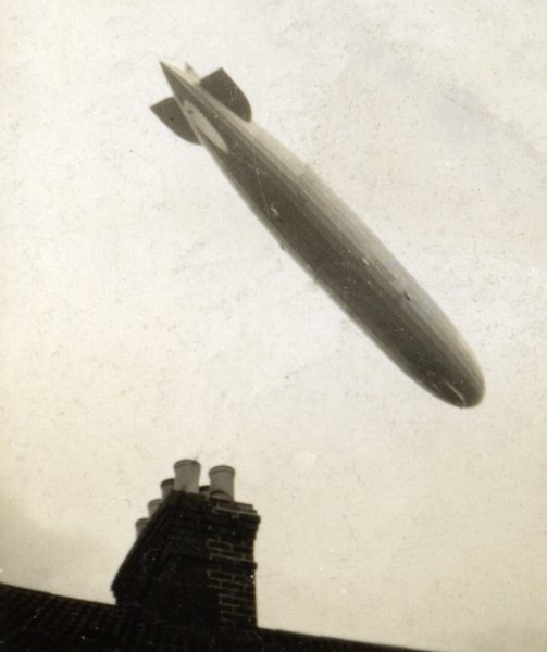
Courtesy of
Stella Trent.
This photograph
features in my
book "A-Z
of Yeovil"
A photograph of the Zeppelin that flew over Yeovil in 1939.
Courtesy of
Yeovil Library
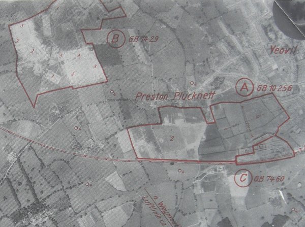
This is part of a German reconnaissance photograph of the Second World War taken by the Zeppelin in 1939 and highlighting the targets of Westland's Airfield (marked 'A'), a temporary army camp (marked 'B') and the Westland factory (marked 'C'). Within 'A' are three aircraft hangers marked '1' in the lower right corner and the airfield itself is marked '2' - note how the airfield has been camouflaged by pouring oil on the grass to create the appearance of hedges around small fields. Within 'B' are several barracks huts, each marked '3'. Dotted around the map and marked '4' are several sites of 'Fesselballons' or barrage balloon sites.