milford Cross
milford Cross
A field named after a crossing of tracks
To say that Milford Cross was a cross-road junction is, perhaps, being a little generous. A crossing of tracks would be more descriptive for most of its existence. Even by 1901, Milford Cross was 'in the middle of nowhere'. Goldcroft, as a made-up road, ended at this point and continued on to Mudford Road simply as a farm track called Gold Croft Lane. While to the west was Sparrow Lane, at this time simply a footpath, and to the east was a farm track sometimes known as Milford Lane, later to become Milford Road. As seen from the aerial photograph below, by 1946 Goldcroft and Sparrow Lane, by now called Sparrow Road, were fully built and surfaced while Milford Lane remained a track. By this time the name of Milford Cross had fallen into disuse.
Originally part of the great medieval Middle Field of Kingston Manor, the field known as Milford Cross took its name from the track crossing and was bounded on the northwest by Milford Lane, on the northeast by Milford Brook, on the southeast by Harbin's Milford (1019) and on the southwest by Goldcroft. It is named on E Watts' map of 1806, shown below.
The 1842 Tithe Map allocated the Parcel Number 1020 to the field and the 1846 Tithe Apportionment described it as pasture. Houses in Goldcroft were built on Milford Cross from the early 1920s, including the experimental Nissen-Petren houses in the northwest corner. During the Second World War and in the immediate post-war period, with the drive to cultivate every spare piece of land for food production, the field was divided into allotments as seen in the aerial photograph below.
Today just under
half of the
field is
occupied by
Goldcroft houses
and their
gardens, about a
quarter of the
field alongside
Milford Brook
(now culverted)
was
re-landscaped to
form part of the
present playing
field while the
remaining
central strip
maintains its
original
contours but is
now waste
ground.
MAP

This map, based on the descriptions in the 1589 Terrier and the 1846 Tithe Map of Yeovil shows the approximate boundaries of the Manors of Kingston and Hendford as well as the manorial three-field system used in Kingston.
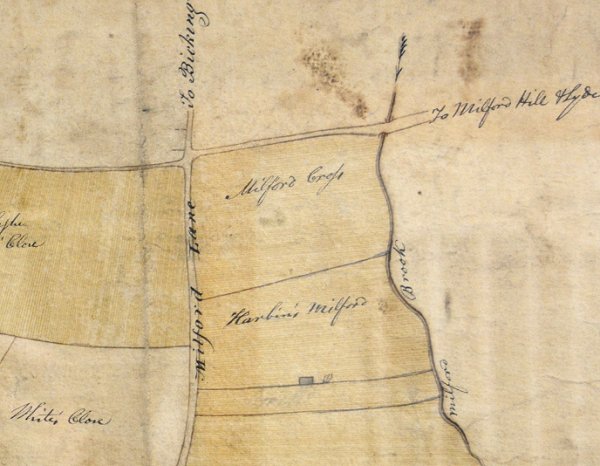
E Watts' map of Yeovil of 1806.
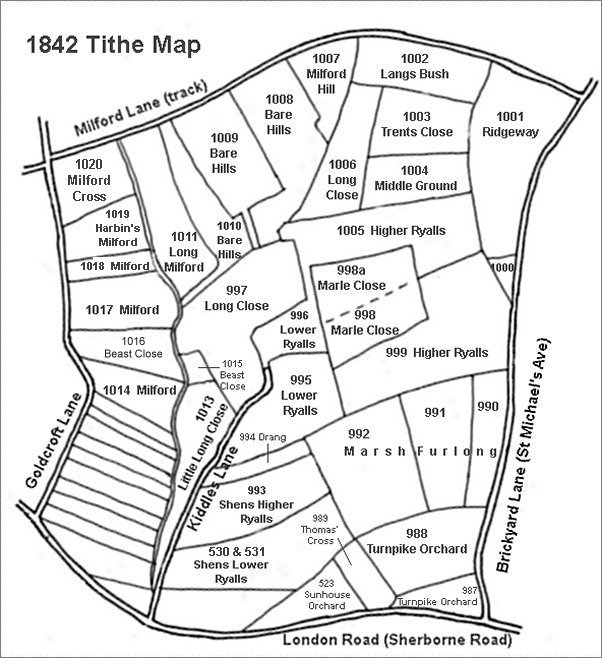
This map is based on the 1842 Tithe Map with field names added from the 1846 Tithe Award.
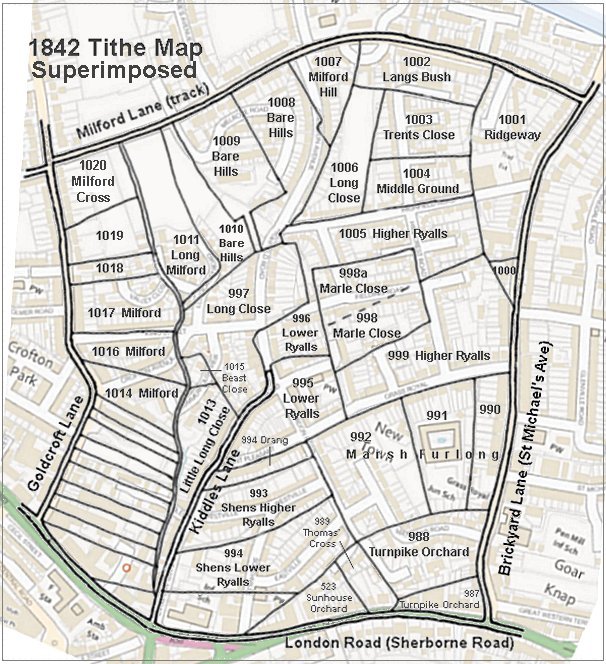
The 1842 Tithe Map superimposed (roughly) over a modern street map showing where several modern roads, for example Gordon Road, Grass Royal and Highfield Road, follow former field boundaries.
gallery
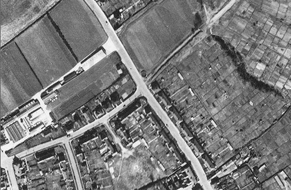
An aerial photograph of 1946 showing Goldcroft running diagonally across the photograph from top left of centre to bottom right of centre and Sparrow Road, fairly recently constructed, running to the bottom left. At centre is Milford Cross with the track known as Milford Lane, later to become Milford Road, running off towards top right. The circular structure on the north corner of Milford Lane is a Second World War emergency water tank and on the southern corner is the pair of experimental Nissen-Petren houses. Note the extensive allotments occupying the right half of the photograph.
The field known as Milford Cross (Parcel 1020) is the roughly diamond-shaped field occupying most of the right half of the photograph, bounded on the northwest by Milford Lane, on the northeast by Milford Brook (delineated by the dark wavy line - trees lining the brook), on the southeast by Parcel 1019 and on the southwest by Goldcroft.