ram park
Ram Park
Home of the 1856 Bath & West Show
Ram Park was a large triangular field west of Kingston and south of Preston Road shown on all nineteenth century maps from Edward Bullock Watts' map of 1806 onwards - see below. The name derives from its early use as an enclosure for rams.
The eastern corner reached the northern end of Clarence Street and its northwestern corner reached Preston Road by means of a very narrow access strip, at a point opposite what is now the entrance to Yeovil Cemetery. A footpath ran along its northern edge, connecting the two roads, and towards the southwestern corner of the field was a pond. To its immediate west was Higher Ram Park and to the east of the northwestern corner Ram Park Orchard fronted Preston Road.
Watts' map of 1831 shows Ram Park in the ownership of the Reverend James Hooper - left to him in the 1825 will of John Hooper, his father "... and my acre and a half of pasture lately thrown into Rampark abutting on the Preston road... ".
The Somerset Gazette Directory of 1840 noted that glove manufacturer Benjamin Glyde owned Rane (sic) Park Cottages. Rampark Cottages were listed in the 1841 Census but with only two households, one of which comprised 35-year old Ann Glyde, her seven children and two servants. From the location in the census the cottages would appear to have been off Kingston behind the Duke of York. In fact, an examination of Watts' 1831 map below shows that Ram Park Cottages could be reached at the end of York Place but actually faced Ram Park and had their own footpath to it just north of the 'dent' in the boundary. It was also in the 1841 census that the Kingston turnpike gate at Fiveways was referred to as Ram Park Gate.
The 1846 Tithe Apportionment noted that Ram Park comprised 11a 1r 25p and was used as pasture for grazing livestock, Higher Ram Park, also pasture, was 8a 0r 28p and Ram Park Orchard was 2a 1r 33p.
On the 4th, 5th and 6th June 1856 Ram Park was home to the Bath & West of England Agricultural Show and the Bath & West of England Poultry Show, and the profits were to be used to aid the Yeovil Mutual Improvement Society and the Yeovil Literary Institution. The Sherborne Mercury, in its edition of 8 April 1856 requested "the loan of Works of Art, Manufactures. Natural Curiosities, Antiquities" and so forth, to be used as exhibits at the show. In the same edition the Local Committee of the Bath & West of England Agricultural Society made an appeal to readers for lodgings during the time of the show "To facilitate the accommodation of Visitors, all Persons having Lodgings to let are recommended to send their names and addresses, with full particulars, etc". One of the exhibitors at the show was Yeovil carriage manufacturer John Hill, at the time only 26 years old. The judges of the show recorded that his carriages "exceed anything in workmanship, lightness or design yet introduced" and the Western Flying Post described him as "the best carriage manufacturer in the West".
The 1858 map of Yeovil shows no changes at all to Ram Park but by 1880 Park Road had been built in the eastern corner along with Christ Church and several villas.
Two houses known as Park Orchard Villas, later to become Girton House School, had been built in Ram Park Orchard by 1886.
During his 1896 mayoral year Sidney Watts presented some three acres of Ram Park, laid out as Sidney Gardens, to Yeovil to commemorate the 1897 diamond jubilee of Queen Victoria, although the gardens were not officially opened until 23 June the following year. The gardens were created at a cost of £760 and Mr Watts graciously named the gardens after himself.
By the time of the 1903 Ordnance Survey map shown below, Ram Park was no more. Park Road had been further extended west and then turned north to join Preston Road, at the same time West Park was constructed and new Edwardian villas were beginning to line both roads.
MAPs
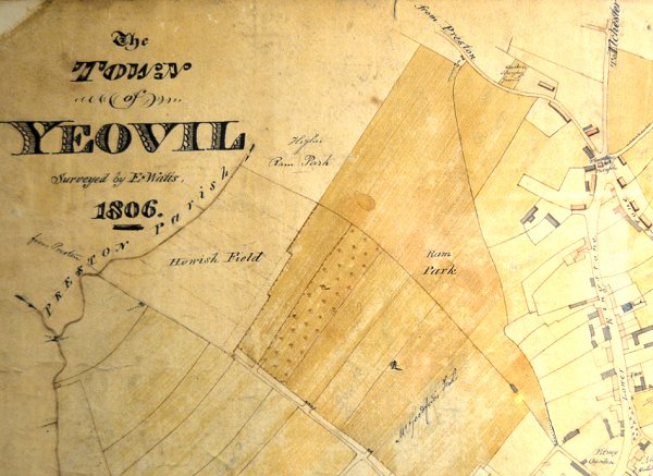
E Watts' map of Yeovil of 1806 shows Ram Park as a large triangular field right of centre and Higher Ram Park at top centre. The small triangular field with its northern edge bordering Preston Road was Ram Park Orchard. A footpath ran along the northern edge of Ram Park, connecting Clarence Street with Preston Road. Top right is Preston Road, at right is Lower Kingston (today's Kingston) and at bottom centre is Hewish Lane (today's Huish) ending at Hewish Field.
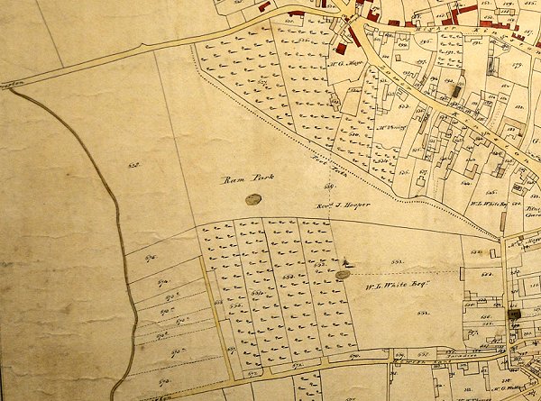
E Watts' map of Yeovil of 1831 (drawn on a different orientation to his earlier map) shows Ram Park in the ownership of the Rev J Hooper. Top left is Preston Road, top right is Lower Kingston (today's Kingston) and at bottom is Hewish Lane (today's Huish).
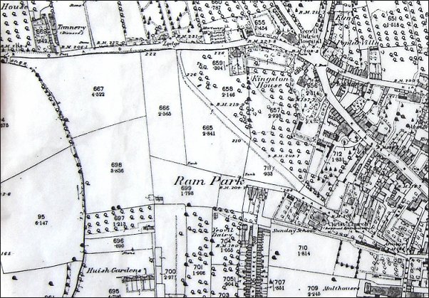
The 1889 Ordnance Survey shows Ram Park subdivided into smaller fields and Park Road has encroached into the eastern corner.
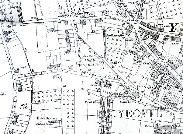
By the time of this 1903 Ordnance Survey Ram Park is no more. Park Road had been further extended west and then turned north to join Preston Road, at the same time West Park was constructed and new Edwardian villas were beginning to line both roads.
Gallery
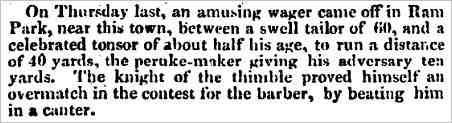
This report is from the 1 April 1833 edition of the Salisbury & Winchester Journal.