hundred acres
hundred acres
A touch of irony in a field name
Hundred Acres (Parcel 1079) was a a small wedge-shaped field of Lower Stone Farm.
The ironic use of this name when applied to very small fields was not at all unusual and there was another of the same name in Preston Plucknett. Originally just a part of the great manorial Middle Field of Kingston, the 1846 Tithe Apportionment noted that Hundred Acres was, in fact, a mere 3a 2r 20p and was used as pasture for grazing animals. The Apportionment noted that Hundred Acres was owned by Henry Goodford of Chilton Cantelo and the tenant was John Newman Berkley.
In 1979, two graves, believed to have been plague victims, were discovered (see Panel below).
An Agreement for a Lease dated 30 August 1849 between Henry Goodford and Nathaniel Bartlett, a baker of Yeovil, for "Land late in the occupation Mr John Newman-Birkley in Yeovil" included "a cottage and garden Hundred Acres 3a 2r 20p.".
Hundred Acres (Parcel 1079) was bounded to the north by Lower Elm Path (1081), to the west by Hollands Farm, to the south by Holcote House and to the east by Mudford Road.
Today Hundred Acres has been built on with the houses and gardens of the western side of Mudford Road from opposite Goldcroft as far south as Holcote House.
For details on historic land measurement (ie acres, roods and perches) click here.
|
A
Plague
Burial
at
Yeovil? "When Mr JL Davidson of 51 Mudford Road began digging a trench for a water-pipe in his front garden, he was astonished to unearth several human bones. Through the local police, they were identified by Bristol Forensic Laboratory as those of a fully-grown male, and were two or three centuries old. With the coroner’s sanction, an excavation was undertaken with the enthusiastic co-operation of the Davidson family. It revealed a double burial in coffins in a grave partly dug into a natural bed of poor limestone occurring just over two feet below ground level. The grave at the head (the south end) was roughly semi-circular, tapering slightly towards the feet (the north end), and to judge from over eighty hand-made iron nails found, held two coffins, one above the other. The bones of the upper skeleton (including those first discovered) had been disturbed and thrown back haphazardly, except for the skull, which lay face downwards close to that of the lower skeleton, and the left thigh-bone with the right smaller leg bone, which lay beside the legs of the lower skeleton. These appear to have been deliberately placed in these positions at a time when the flesh had already decomposed, but the wood of the coffins had not yet completely decayed. Thus hollows would have existed around the lower skeleton into which the skull and the two bones could have been inserted, the remainder being thrown back in at all angles. The reason for this disturbance is not clear, although a clue may be afforded by a few animal bones also found in the disturbed soil. There was no sign of more recent disturbance of the clay ‘fill’. The upper skeleton was that of an adult male, about 5 feet 8 inches in height, and at least 40 years of age. The lower skeleton was articulated, the head turned slightly to the left with jaws fully open showing an excellent set of teeth. The lower arms rested across the chest, and the legs were fully extended. This was also an adult male, 5 feet 6½ inches tall and about 40 years of age. Two fragments of the bowl of a clay tobacco pipe were found, both associated with the lower skeleton; one among the bones of the feet, and one near the lower spine. They fit together, forming a nearly complete bowl with a maker’s mark stamped in relief on the base – I.D. Dr Roger Price, of the Department of Archaeology, Bristol Museum, who has made a study of local pipe makers, writes that the maker could have been John Davye who was apprenticed to a Bristol maker in 1623, but that the shape of the bowl suggests a later date, probably c1660-80. A Bath pipe maker, John Ducy, was in business c1700, and the pipe could be one of his. No pipe maker with these initials is known in Somerset or Dorset, during the 17th century. If the early date is the correct one, the burials can be related to a serious outbreak of plague in Yeovil in 1646-7. Quarter Sessions records mention "the great contagon in Yevele werein mane hundred soules died, the sickness growing so dangerous that no living would undertake to bury the deade infected bodies". Finally the constables of the hundred and the borough persuaded four men to do the work at 1s 4d a day, taking eleven weeks to complete it. The Mudford Road grave was dug in a field called Hundred Acres on Lower Stone Farm, now part of the Recreation Ground. If the latter date is accepted (as is more likely), then the burials may be linked with lesser outbreaks of the plague known to have occurred in the late 17th century. Unfortunately, the Burial Register for this period has several gaps, but the year 1698 certainly had an unusually large number of deaths. The bones have now been replaced in the original grave, but the clay pipe fragments are on display in Yeovil Museum together with a photographic record of the excavation by Mr R.Woodward."
Burials
in
Mudford
Road Readers of ‘Chronicle’ will recollect an article in Vol.1, No.3, on ‘A Plague burial in Yeovil?’ describing the discovery of two skeletons in the front garden of 51 Mudford Road. Internal evidence gave a date towards the end of the 17th century, and it was suggested that such an isolated internment might indicate a plague burial. Mr Leslie Brooke has recently found in the Somerset Record Office ‘A Survey of all the lands that pay Tythe to the Parsonage of Yeovill’ dated 1743. It mentions a “Burying Plot’ near Green Cross (Tithe Map 1830), which is almost certainly the field on which houses were built fifty years ago on Mudford Road, near the entrance to the Recreation Ground. It is very likely that the two burials (in wooden coffins placed in a carefully made grave cut into the natural rock) are within the Burying Plot. Such cemeteries are known for the Quakers and the Baptists, and the Mudford Road one probably served the Unitarians who certainly flourished in Yeovil from the 17th century.
|
map

This map, based on the descriptions in the 1589 Terrier and the 1846 Tithe Map of Yeovil shows the approximate boundaries of the Manors of Kingston and Hendford as well as the manorial three-field system used in Kingston.
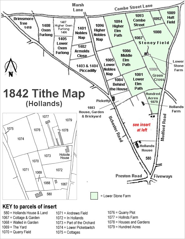
The Hollands area reproduced from the 1842 Tithe Map. Hundred Acres is centre right.
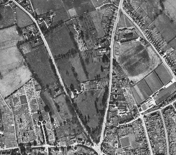
The 1946 aerial photograph showing Hundred Acres built on with the houses opposite the entrance to Goldcroft at top, right of centre, and running down to Holcote House.
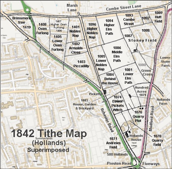
The 1842 Tithe Map superimposed over a modern map.