Higher Sleight & Lower Sleight
Higher Sleight & Lower Sleight
Two large fields in Preston Plucknett
Lower Sleight and Higher Sleight were originally part of a large field called Deane, or Dean Field, to the north of St James' church, Preston Plucknett.
At the time of the 1763 Survey of the Manor of Preston, the fields were called Lower Slade (to the south) and Higher Slade (to the north). Using the 'old' system of land measurement, Lower Slade measured 26 acres, 3 roods, 13 perches and Higher Slade measured 17 acres, 0 roods, 6 perches. Both were used as pasture for grazing livestock.
The 1846 Preston Tithe Map shows both fields largely unaltered although small parts of Lower Sleight had been used to form small, new enclosures. The Preston Plucknett Tithe Apportionment of 1848 noted that both Lower Sleight (Parcel 103) and Higher Sleight (Parcel 81) were owned by Lady Georgiana Fane of Brympton d'Evercy and the tenant was Thomas Hawkins (who was a tenant of over 200 acres in over 40 parcels in the parish). Using the 'new' system of measurements, Lower Sleight was reckoned as 28 acres, 1 roods and 22 perches and Higher Sleight measured 18 acres, 2 roods and 7 perches. Both were still used as pasture.
Both Higher and Lower Sleight were bounded on the west by the field access track, known as Eighteen Acre Lane. They were both bounded to the east by Dodham Brook. To the north, Higher Sleight was bounded by Arable Dean (Parcel 80) and to the south Lower Sleight was bounded by several properties on the north side of Preston Lane (today's Preston Road), including St James' church.
The Preston Plucknett Flax Works was, during the latter part of the nineteenth century, built in the northwest corner of Higher Sleight and was accessed by Eighteen Acre Lane, a field access track which is now a footpath running through the Abbey Manor housing estate. Some of the Flax Works buildings still survive as small industrial units on the Abbey Trading Estate, off Stourton Way to the west.
Both fields disappeared when Abbey Manor was built in the 1980s. Higher Sleight is now occupied by part of Stourton Way, Athelney Way, Glastonbury Court, Shelley Court, Beaulieu Drive, Horton Close and Plover Court. The western portion of Higher Sleight is now occupied by the Abbey Trading Estate.
Lower Sleight is now occupied by part of Stourton Way, White Mead, Malvern Court, Bowleaze, Netley and Tewkesbury as well as much of the fields of Preston School.
For details on historic land measurement (ie acres, roods and perches) click here.
map & Aerial photograph
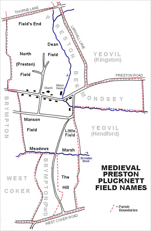
The main post-medieval fields of Preston Plucknett.
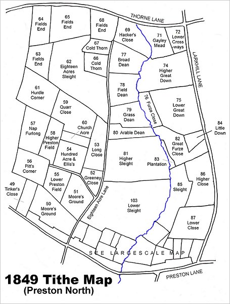
Map based on the 1849 Tithe Map showing Higher Sleight and Lower Sleight at centre towards the botton, lying between the field access track, Eighteen Acre Lane (now a footpath), running up the centre of the map and Dodham Brook to the east.
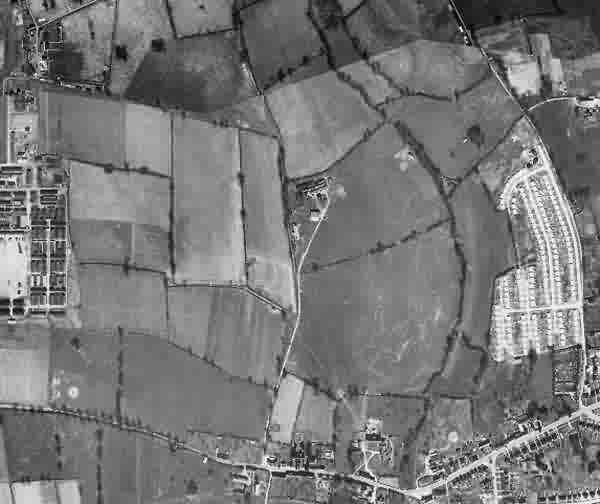
This is a 1946 aerial photograph showing Broad Dean at top centre, with Hackers Close (partly shown) to the north, Cold Thorn to the east, Grass Dean to its south, and Dodham Brook to the east. At lower left of the photograph is Houndstone army camp and at lower right is the post-war Larkhill Lane pre-fabricated housing estate. At centre is the Preston Plucknett Flax Works.
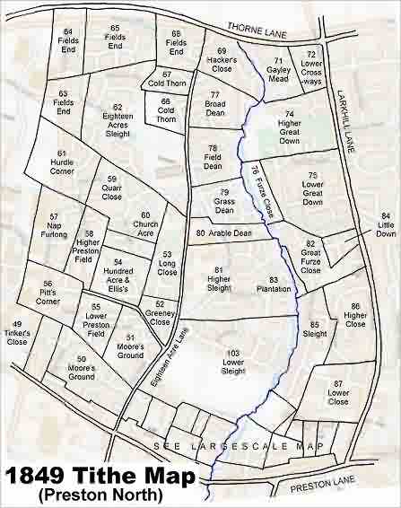
The 1849 Tithe Map superimposed over the modern Ordnance Survey map.