Park Street
park Street
Pubs, pubs and more pubs
Park Street was laid out and built by Peter Daniell between 1825 and 1834 along the edge of his Penn House estate. It ran from its junction with South Street in a southerly direction around the flank of Penn Hill. At the point where Penn Hill (the road) joined Park Street, Park Street became Belmont and, finally, Brunswick Street.
Old Yeovilians will recall the four pubs in Park Street, Yeovil's longest (and many would say roughest) road, because that was all that remained in living memory after a couple shut and two became lodging houses in the early 20th century. However there had been, for much of the 19th century, nine pubs in this road (which comprised Park Street, Belmont and Brunswick Street). These were (in alphabetical order) Britannia Inn 1, Cross Keys 2, Dolphin Inn, Globe Inn, Glovers Arms 1, Golden Lion, Rifleman's Arms, Swan Inn 2 and the Volunteer Inn.
During the 19th century Park Street / Belmont / Brunswick Street acquired an unsavoury reputation primarily because it had nine named pubs and a minimum of an additional six beerhouses - a total of fifteen drinking establishments.
Almost all the buildings in Park Street were demolished in the 1960s.
See also - Chaffey's Court, Cross Keys Row, Park Place and Park Row.
MAP & Aerial photograph
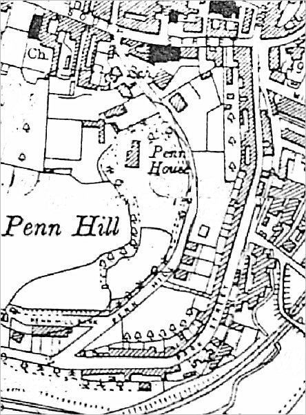
The 1927 Ordnance Survey showing Park Street down the right side of the map from South Street which runs across the top of the map. At the point where Pen Hill joined Park Street, Park Street became Belmont and, finally, Brunswick Street.

An aerial photograph of 1953 showing the whole length of Park Street running across the centre of the photograph from its junction with Penn Hill and Belmont at left (obscured by trees) to its junction with South Street at right.
gallery
From my
collection
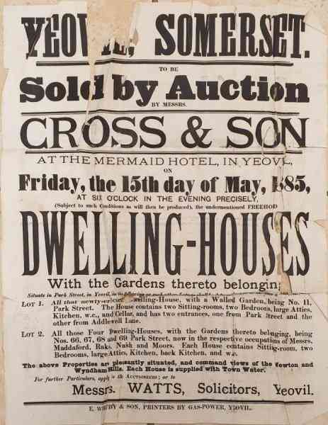
A notice of sale by auction, on 15 May 1885, of five properties in Park Street in two lots:
Lot 1 - All that newly-erected Dwelling House, with a Walled Garden, being No 11, Park Street. The House contains two Sitting-rooms, two Bedrooms, large Attics, Kitchen, W.C., and Cellar, and has two entrances, one from Park Street and the other from Addlewell Lane.
Lot 2 - All those Four Dwelling-Houses, with Gardens thereto belonging, being Nos. 66, 67, 68 and 69 Park Street, now in the respective occupations of Messrs. Maddaford, Rake, Naish and Moors. Each House contains Sitting-room, two Bedrooms, large Attics, Kitchen, back Kitchen and W.C.
From my
collection
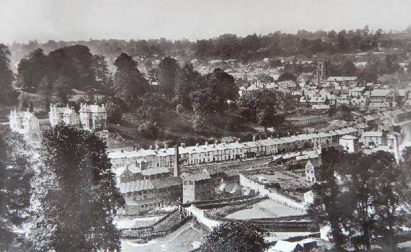
The view across to Pen Hill (top left quadrant), Park Street (running across the centre) and Victoria Bridge (bottom centre). From a postcard of 1911.
Courtesy of
Betty Barber
(née Bird).
This
photograph
features in my
book "Lost Yeovil"
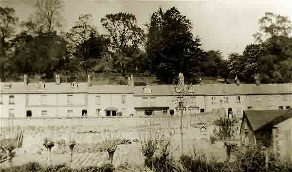
Houses in Park Street photographed from across the valley during the 1930s.
The original of
this
photograph
features in my
book "Lost Yeovil"
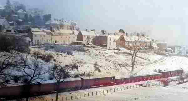
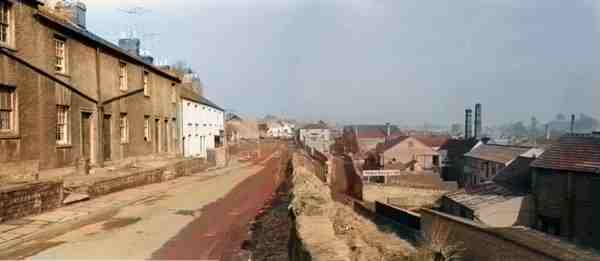
A colourised wintry scene of snow-covered houses of Park Street on the flanks of Penn Hill overlooking the passing goods train on its way to Taunton in the 1950s.
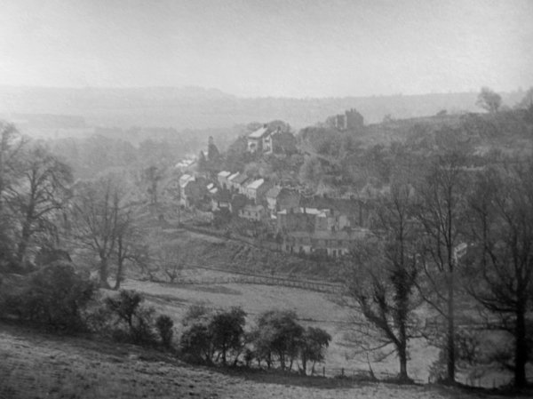
Photo by Bernard
White. Courtesy of South Somerset Heritage Collection
Park Street photographed from across the valley during the early 1950s.
From the Cave
Collection
(colourised),
Courtesy of South Somerset Heritage Collection
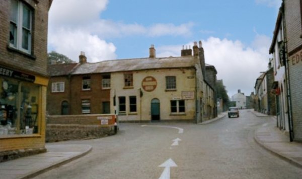
The northern end of Park Street as it joined South Street. By this time the Globe Inn had closed and was awaiting demolition. Note how the main A30 traffic is directed around in front of the Globe Inn, down Park Street. Today this section of Park Street is the only part surviving at its original level and is now a small car park. At left, beyond McCreery's shop, is Addlewell Lane, now the main route through to the modern Park Street.
From the Cave
Collection,
Courtesy of South Somerset Heritage Collection
This colourised photograph shows the Globe Inn awaiting demolition. The cottages either side - in Park Street to the left and South Street to the right, were demolished at the same time. This photograph was taken from the southern end of Bond Street and the short wall at extreme right is that of the Woborn Almshouse, built here in 1860 after its previous building, behind the Pall Tavern, fell into ruin.
From the Cave
Collection,
Courtesy of South Somerset Heritage Collection
Almost the same view as the previous photograph, but here the Globe and the adjoining cottages have been demolished. Photographed in the 1960s.
Courtesy of
Roger Froude
The northern end of Addlewell Lane, with Park Street at right, photographed in the 1950s.
Courtesy of Rob
Baker. This
photograph
features in my
book "Now
That's What I
Call Yeovil"
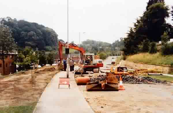
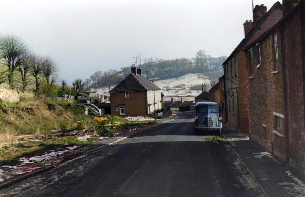
The northern end of Park Street being realigned during 1987 to form Taunnusstein Way. The last remnant of this part of Park Street became a tiny car park.
Courtesy of
Roger Froude
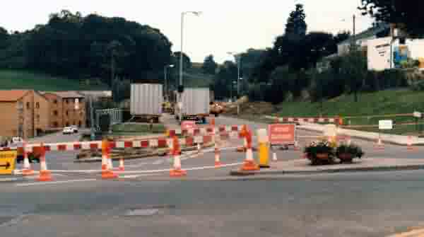
Park Street is closed off at its northern end (seen here with South Street running across the bottom of the photo) while Taunnusstein Way and the new car park take shape.
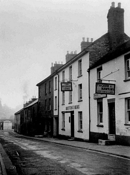
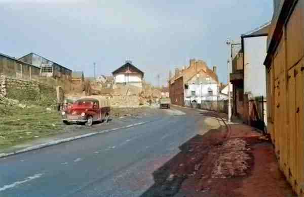
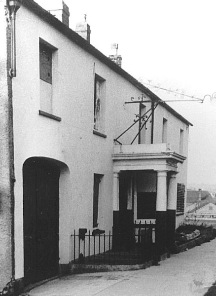
This photograph of the Rifleman's Arms in Park Street dates to 1956, shortly before demolition.

The block of houses to the immediate south of the Rifleman's Arms. A colourised photograph of 1959.

.... and moving just a little further down Park Street. Photographed in 1959.
Courtesy of
David Perry
-
This
colourised photograph
features in my
book 'Yeovil From Old Photographs'.
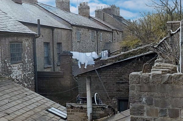
A particularly evocative image of the tiny back yards of some of the Park Street houses. Photographed in the early 1960s.

The steps from Park Street leading to Penn Hill. In a colourised photograph of 1959.

.... and a photograph of the rest of the terrace, The steps of the previous photograph are between the last white house and the red house seen here. Photographed in 1959.
From the Cave
Collection
(colourised),
Courtesy of South Somerset Heritage Collection
.... and a photograph of the rest of the terrace, taken from the position of the previous photograph, but in this case photographed around 1963.
From the Cave
Collection
(colourised),
Courtesy of South Somerset Heritage Collection
Houses just a little further down Park Street. Photographed around 1965.

.... and the next houses along in a colourised photograph of 1959.
From the Cave
Collection
(colourised),
Courtesy of South Somerset Heritage Collection
A colourised photograph from almost the same position, looking back along Park Street in the early 1960s. Demolition has already begun by the white terrace at centre. Addlewell Lane is at right.
From the Cave
Collection
(colourised),
Courtesy of South Somerset Heritage Collection
A colourised photograph off around 1965, looking towards South Street and showing the continuing demolition of houses.
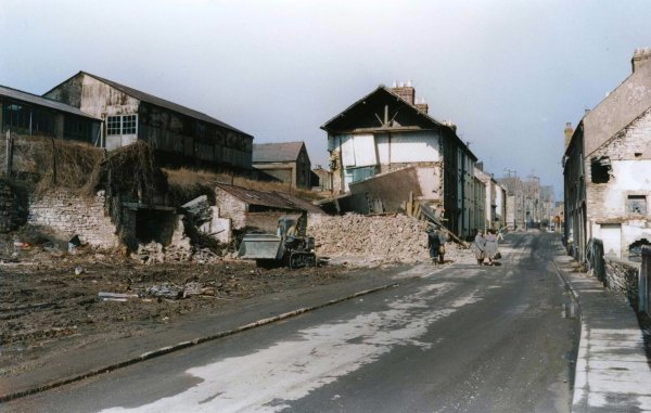
From the Cave
Collection
(colourised),
Courtesy of South Somerset Heritage Collection
The same view, but a little closer to South Street.
Another colourised photograph of around 1965, looking down from Park Street to Addlewell Lane and Belmont Street at right of centre.

Courtesy of
David Perry
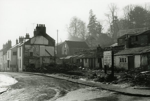
The demolition of Park Street. A colourised photograph of the early 1960s.

Courtesy of
David Perry
Park Street outhouses around the time of demolition in a colourised photo of the early 1960s.

This transport hotel was one of the first buildings encountered on the south side of Park Street when travelling from South Street. Its elevation to Park Street was single storey but it was three storeys facing Addlewell Lane. Photographed in 1956.

Many thanks to Rob Baker who sent me the above colourised photograph. It is a clipping from the Express and Star of some twenty years ago and the photograph had been sent in by Flo Essex (Rob's great-aunt) - the photograph shows Rob's great-gran, Florence Thorne (at left) who ran the Cross Keys lodging house in Park Street with her mother and father. She is pictured outside the Cross Keys with her own mother, Helen (Rob's great-great-gran at centre), and daughters Caroline and Theresa.

Courtesy of
Colin Haine.
This photograph
features in my
book "Now
That's What I
Call Yeovil"
One of the few remnants of Park Street surviving today are Penn Steps, leading from Park Street up to Penn Hill and still offering wonderful views across to Summerhouse Hill from the top. Photographed in 1986.
The Swan Inn, circa 1950.
Photographed by
Geoff Bowler,
courtesy of Sue
Bowler
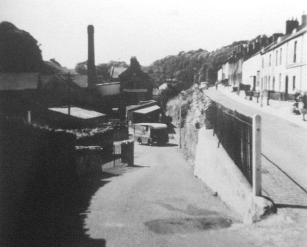
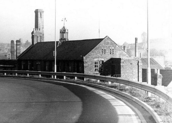
The glove factory of Clothier, Giles & Co in Addlewell Lane, seen from the bend in Park Street opposite the Swan Inn. Photographed in 1969.
From the Cave
Collection
(colourised),
Courtesy of South Somerset Heritage Collection
... and seen from a bit further away.
From the Cave
Collection
(colourised),
Courtesy of South Somerset Heritage Collection
This photograph, taken in 1963 from Park Street, looks across to the terrace of cheap housing known as Victoria Buildings. Right of centre is Victoria Bridge crossing the railway and clearly showing how Addlewell Lane was raised up either side of the railway.

One of the last houses in Park Street before it merged into Belmont. A colourised photograph of the 1960s.
From the Cave
Collection
(colourised),
Courtesy of South Somerset Heritage Collection
Again photographed in 1963, this view is taken from west of the sharp bend and looks south.
From the Cave
Collection
(colourised),
Courtesy of South Somerset Heritage Collection
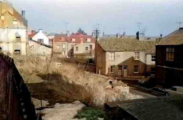
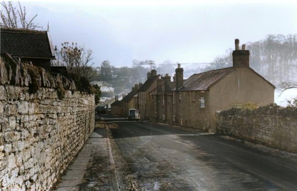
And moving a little further along, the southern end of Park Street originally had houses on both sides of the road. Photographed during the 1960s.

At this point Park Street (the junction with Penn Hill, at left) became Belmont and finally Brunswick Street where it joined Hendford.