Priscilla's Close
Priscilla's Close
Once part of the great medieval East Field of Kingston Manor
Priscilla's Close was a field that had originally formed part of the great medieval East Field of Kingston Manor and was part of a large sub-field called Reckless Lake.
Who Priscilla was is not known, however the next field is called Parcellas (the name Parcellas may come from the Latin particula meaning a part, or piece, and parcella came to mean a parcel of land), so was Parcellas a corruption of Priscilla's? or the other way around?
In any event Priscilla's Close (Parcel 878) was shown on the 1842 Tithe Map but unfortunately was not recorded in the 1846 Tithe Apportionment so no details of ownership are known. However a Counterpart of Lease for seven years dated 25 March 1859 between Captain William Prowse of Enham House, Southampton, Retired Captain RN, and John Stone of Pen Mill Inn for both the inn and the adjoining farm, included Priscilla's Close. The lease noted that the field was used as arable for growing crops and measured 4a 0r 10p.
Priscilla's Close (Parcel 878) was bounded on the north by Lyde Lane, on the west by an un-named field (Parcel 877), on the south by Holloways Close (Parcel 875) and Reckless Lake (Parcel 880) and on the east by Parcellas (Parcel 879).
Today Parcellas is covered by buildings of the Pen Mill Trading Estate, at the junction of Buckland Road and Vale Road (which follows the line of the original Lyde Road).
For details on historic land measurement (ie acres, roods and perches) click here.
maps & Aerial photographs

This map, based on the descriptions in the 1589 Terrier and the 1846 Tithe Map of Yeovil shows the approximate boundaries of the Manors of Kingston and Hendford as well as the manorial three-field system used in Kingston.

A map of the great medieval East Field of Kingston Manor showing conjectured locations of several fields based on descriptions in the 1589 Terrier.
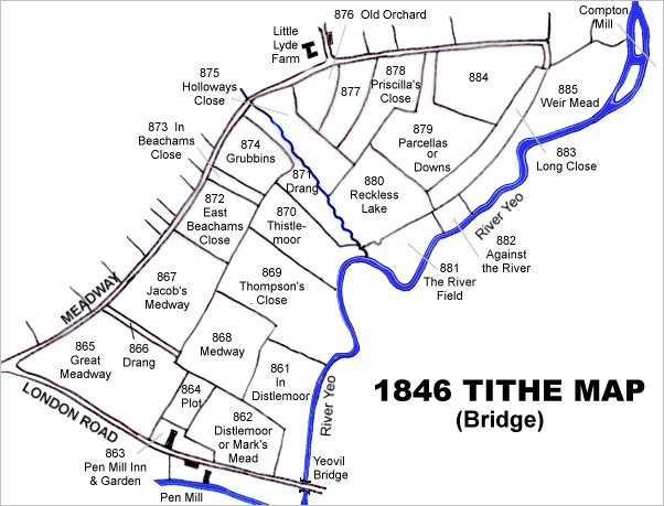
This map is based on the 1842 Tithe Map with field names chiefly added from the 1846 Tithe Apportionment.
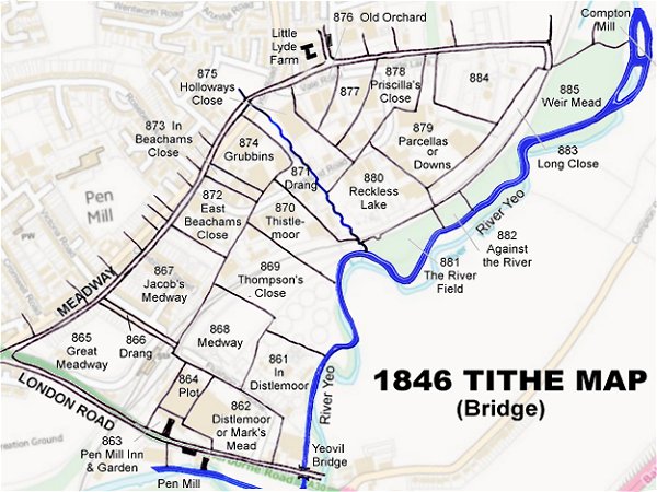
The 1842 Tithe Map superimposed (roughly) over a modern street map. Bearing in mind the relatively primitive surveying equipment of the 1840s they weren't all that far out.