Roy
Roy
Lower Carent's Farm, Yeovil Marsh
Roy (Parcels 1233, 1234, 1235, 1236 and 1237) was originally a single large 22-acre field of Lower Carent's Farm in Yeovil Marsh. The name 'Roy' is probably a reference to rye as a crop grown in the field in earlier times.
Roy was owned by the Woborn Almshouse, sub-letting it and collecting annual rents. The table below shows who the field was rented to.
|
Year |
Tenants / Sub-Tenants |
|
1727 |
Will of William Goodford; £10 charge on lands in Marsh (3 closes, 12 acres) |
|
1746 |
Widow Martha Mead, Rent £2 12s 6d pa |
|
1767 |
Thomas Mead, Rent £15 pa |
|
1773 |
Edward Ball, Rent £15 pa |
|
1786 |
John Martin, Rent £15 pa |
|
1796 |
John Martin, Rent £21 pa |
|
1800 |
Mr Tomkins |
|
1801 |
John Jeffery, Rent £26 pa |
|
1812 |
William Spear, Rent £34 pa |
|
1822 |
Messrs Spear & Pope, Rent £18 pa |
|
1828 |
William Symes late Spear's, Rent £26 pa |
|
1862 |
William Symes, Rent £25 pa |
By the time of the 1846 Tithe Apportionment, Roy had been divided into five smaller parcels. Parcel 1237 was owned by Charles John Helyar, but the other four parcels, all named Roy, were still owned by Yeovil Almshouse. The farm (as well as several other farms) was let to William Symes of Yeovil Marsh.
-
Roy (Parcel 1233) was listed as meadow for growing hay and measured 2a 2r 30p.
-
Roy (Parcel 1234) was listed as arable for growing crops and measured 4a 3r 0p.
-
Roy (Parcel 1235) was listed as meadow for growing hay and measured 3a 2r 20p.
-
Roy (Parcel 1236) was listed as meadow for growing hay and measured 3a 3r 30p.
-
Roy (Parcel 1237) was listed as arable for growing crops and measured 7a 2r 30p.
For details on historic land measurement (ie acres, roods and perches) click here.
MAP
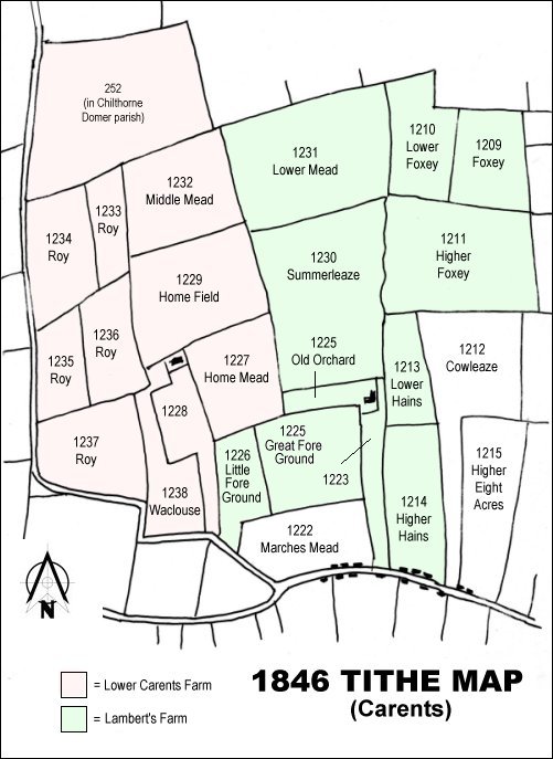
At the time of the 1919 sale of the six Marsh farms, Lower Carent's Farm is shown in pink and Lambert's Farm is shown in green.