Second Close
Second Close
A part of Preston Lower farm
Second Close (Parcel 137), also known as Second Sleight, was an L-shaped field at the centre of Preston Lower Farm - 'sleight' comes from the Old English sloeget, meaning a sheep pasture. Anciently the leghs (later corrupted to sleights) meant large, noble grounds or pastures. It was known as Second Sleight since the field called Cow Leaze (Parcel 134), or First Sleight, was closer to the farm buildings.
The 1848 Preston Tithe Apportionment described Second Close as pasture for grazing livestock and noted that it measured 10a 1r 5p. The Apportionment recorded that Second Close was owned by Robert Tucker and occupied by Joseph Roberts.
John Brook the Younger became the tenant farmer, replacing Joseph Roberts, in 1857. He was the tenant farmer until his retirement around 1878.
Second Close was bounded on the north by Seven & Eight Acres (Parcel 139) and Four Acres (Parcel 138), on the west by Cow Leaze (Parcel 134), to the south by the Old Mill Leat and to the east by a small brook.
As seen from the 1889 Ordnance Survey map below, Second Close was still an open field with a footpath running through it (connecting Preston Road with Huish) but had, by this time, been combined with Four Acres to form a larger field and the 1927 aerial photograph shows that it remained open until this time. By 1946 the aerial photograph shows that the former Second Close contained the houses and gardens of the central section of Preston Grove and the eastern end of Westbourne Grove.
For details on historic land measurement (ie acres, roods and perches) click here.
MAPS & Aerial Photographs
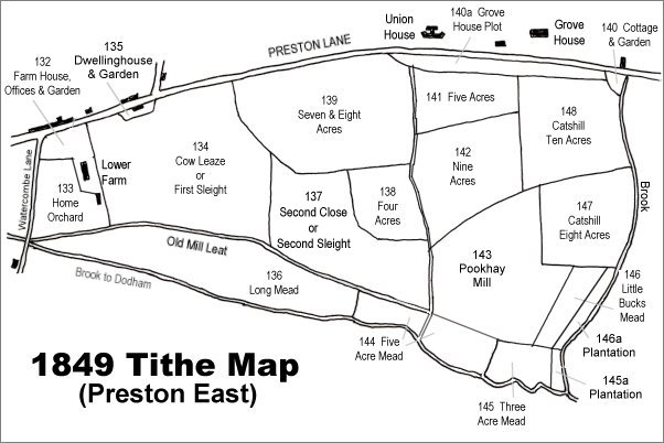
The 1849 Preston Tithe Map. Second Close is at centre.
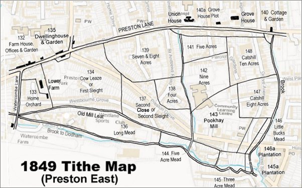
The 1849 Preston Tithe Map overlaid on a modern map.
The 1889 Ordnance Survey shows Lower Farm at lower left with extensive fields labelled 'Preston Grove' stretching eastwards. Second Close, now combined with Four Acres, is towards bottom right.

An aerial photograph of 1927, looking southeast. Preston Road runs across lower left and Watercombe Lane is at lower right while Westland's airfield is at top right and relatively newly-built Preston Grove runs up the left of the photograph. Preston Lower Farm is at centre bottom. Second Close, now combined with Four Acres, is at top left with its former boundaries shown red and the former boundary of Four Acres shown as a broken red line.

An aerial photograph of 1946 showing the approximate boundary of the former L-shaped Second Close shown in red and by this time containing the houses and gardens of the central section of Preston Grove and the eastern end of Westbourne Grove.