Brickyard Lane
Brickyard Lane
Today's St Michael's Avenue
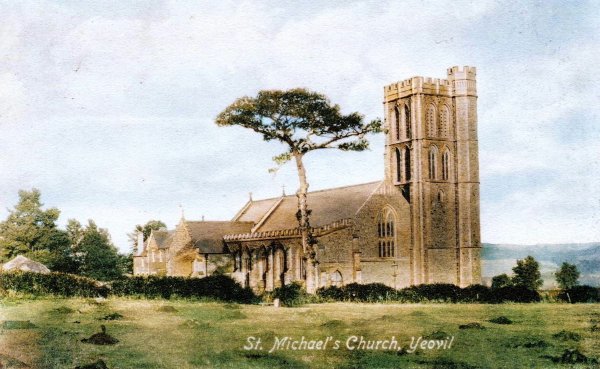
Brickyard Lane was the original name of today's St Michael's Avenue. The name only changed after the opening of St Michael & All Angels’ church in 1897. Indeed, the section from Milford Lane to Mudford Road was still called Brickyard Lane on the 1928 Ordnance Survey.
The 1854 Burgess Roll refers to Goar Knap Lane - another early name of today's St Michael's Avenue.
There had been, in fact, three brickyards in Brickyard Lane which, until the early twentieth century, was bounded by fields for almost its entire length (see first map). Indeed, in 1811 and still in 1842 there were no houses at all for its entire length.
The northern brickyard (see second map) was described in the 1846 Tithe Apportionment as the 'Old Brickyard'. At the time of the Apportionment is was used as pasture for grazing livestock and measured 3 acres, 1 rood and 10 perches (for an explanation of Historic Land Measurement - click here). It was owned by William Edwards and leased by George Ricketts. Its location now lies under the Bucklers Mead Astro-Turf football pitch.
The second brickyard (see third map) was opposite the first, but operated at a later date. The 1889 Ordnance Survey map noted it as "Brick & Tile Works". This had been Parcel 1035, named Gillard's Close, in the 1846 Tithe Apportionment, at which time it was owned by Ann Collins and occupied by James Marten. In 1846 it was a three-acre field used as pasture for grazing livestock. The later brickyard, owned by Richard Bicknell, is now the site of Bicknell Gardens.
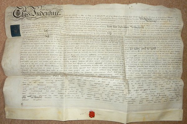
The southern, or third, brickyard (see fourth map) was in Goar Knap, close to the London Road (today's Sherborne Road). Robert Jennings was listed as a brick maker in Pigot's Directory of 1822, although years earlier an indenture in my collection dated 2 July 1814 shows him to have purchased from Yeoman farmer Samuel Isaac, a brickyard for the sum of £201 5s (around £150,000 at today's value) on land to the south of land he already owned for the "absolute purchase of the same piece or parcel of land with the Brick Kiln and other new erections and buildings now standing and being thereon". The land was described as "All that piece or parcel of arable land containing by estimation one acre.... situate lying and being in Gorefield (Goar Knap) in the parish of Yeovil aforesaid lately converted into a Brickyard bounded on the north by the land of the said Robert Jennings and on the South by lands of James Tucker together with the Brick Kiln and all and singular other outhouse and buildings lately erected and built by the said Samuel Isaac and now standing and being thereon....".
The brickyard, shown as Parcel 982 on the map below, is now the site of the former White Horse.
Map
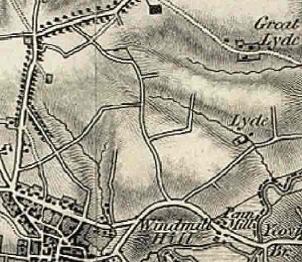
The 1811 Ordnance Survey map showing Brickyard Lane at centre, running from the London Road at bottom to Mudford Road at top. Not a single building to be seen at this time, although it's nice to imagine what Mudford Road looked like at this time within its avenue of trees.
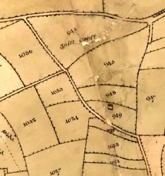
The northern brickyard. This is a portion of the 1842 Tithe Map. Mudford Road runs across the top and Brickyard Lane winds its way up from bottom right to top left. Parcel 948, just off right of centre, was labelled "Old Brickyard" in the 1846 Tithe Apportionment. (The road running off to centre left doesn't exist any more). Today, the former Parcel 948 lies under the Bucklers Mead Astro-Turf football pitch.
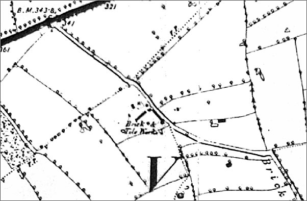
A part of the 1889 Ordnance Survey map featuring, as a thick black line at top left, Mudford Road and running diagonally across the map is Brickyard Lane, today's St Michael's Avenue. At centre is the "Brick & Tile Works" - the second of Brickyard Lane. This had been Parcel 1035, named Gillard's Close, in the 1846 Tithe Apportionment, at which time it was owned by Ann Collins and occupied by James Marten. This brickyard, owned by Richard Bicknell, is now the site of Bicknell Gardens.
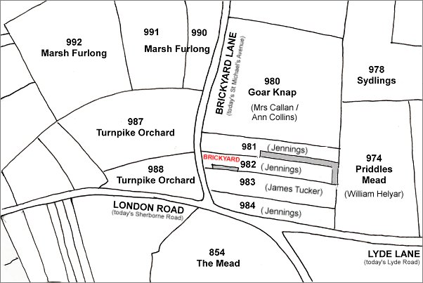
The southern brickyard, the third of Brickyard Lane. This map is based on the 1842 Tithe Map. Parcel 982 was that parcel "lately converted into a Brickyard", Parcel 981 contained New Prospect Place built and owned by Robert Jennings (his son William had inherited the lands by 1846) - "bounded on the north by the land of the said Robert Jennings". Parcel 983 was "on the South by lands of James Tucker" - this is now the site of Great Western Terrace.
gallery
From my
collection
The indenture dated 2 July 1814, in which Robert Jennings bought the brickworks from Samuel Isaac for £201 5s.

The Pen Mill Supply Stores, on the corner of Great Western Terrace and St Michaels Avenue, photographed around 1905.
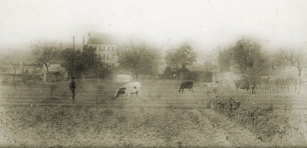
Photographed around 1890, and looking towards Brickyard Lane (today's St Michael's Avenue), this is a photograph of the field called Goar Knap (Parcel 980 on the above map) on which the new St Michael & All Angels’ church would shortly be built.
From my
collection
-
This colourised photograph
features in my
book 'Yeovil
From Old
Photographs'
The newly-built St Michael's church is seen from the field Marsh Furlong (Parcel 980) the other side of St Michael's Avenue (at the hedge-line) around 1897, before this section of the road became built-up after 1912.

This colorised photograph dates to 1912 and shows St Michael & All Angels’ church tower at left, new houses in St Michael's Avenue at centre and St Michael's Hall (completed in 1908) in the newly-built St Michael's Road at right.

From my
collection
-
This colourised photograph
features in my
book 'Yeovil From Old Photographs'.
A postcard of 1920 looking south down St Michael's Avenue towards the church.
This
image
features in my
book 'Yeovil
- The Postcard
Collection'.
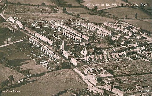
An aerial postcard of the very early 1920s with St Michael's church at centre. This photograph demonstrates remarkably well how isolated this part of Yeovil was at the time; St Michael's Avenue runs diagonally across the image from bottom right to top left, the first road off to its right is St Michael's Road, the last road off to the right towards the top of the photo is the partly-built Rosebery Avenue and the three roads between are, from left to right, Glenville Road, Percy Road and Alexandra Road.