yeovil people
Samuel Isaac
Yeoman and Gentleman
Samuel Isaac was born in Yeovil in 1783 and his baptism, on 24 July 1783, was recorded in the Yeovil Quaker Register of Baptisms. He was the son of yeoman Samuel Isaac (1744-1838), originally of Montacute, and Eleanor née Barrett (1746-1828). Samuel and Eleanor were Quakers and married at the Quaker Meeting House in Yeovil in 1782. The family home of the Isaac family was the farmhouse on Reckleford later to become the Glovers Arms. Samuel Jnr had three siblings; Mary (1785-1785), Mary (b1789) and Thomas (1790-1871).
Although records are scarce it is thought that Samuel remained a bachelor and had inherited his father's estate.
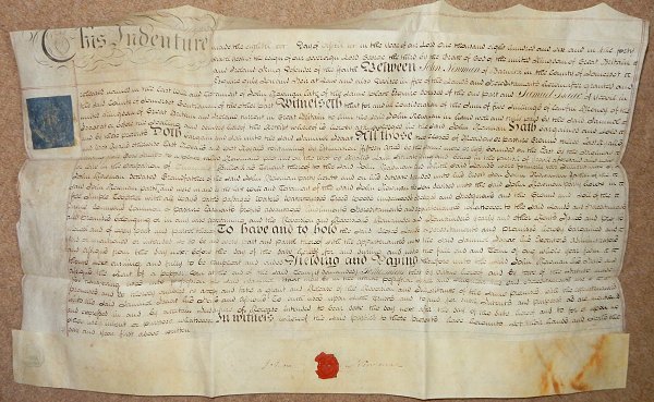
An indenture in my collection dated 8 April 1806 shows Samuel Isaac to have leased two fields from John Newman of Barwick for five shillings a year. The land in question was "All those two closes of Meadow or Pasture Ground called East Ryalls and West Ryalls otherwise East Royals and West Royals containing by Estimation Fifteen Acres (be the same more or less) bounded on the East by the Highway (today's St Michael's Avenue) leading from Gore Knapp to a place called Newman's plot and on the West by Ryalls Lane (today's Eastland Road) situate lying and being in the parish of Yeovil aforesaid and now or late in the occupation of Thomas Bullock as Tenant thereof to the said John Newman and which said Lands were formerly the Inheritance of John Newman Deceased Grandfather of the said John Newman party hereto and on his decease descended unto his Eldest Son John Newman Father of the said John Newman party hereto and were in and by the last Will and Testament of the said John Newman the son devised unto the said John Newman party hereto in Fee Simple....".
To give an idea of the extent of this land, it stretched from today's St Michael's Avenue to today's Eastland Road and its southern boundary was the whole length of Grass Royal (no prizes for guessing the origin of that name) and Mount Pleasant.
By the time of the 1842 Tithe Map these two fields had been subdivided into the following parcels
West Ryalls
divided into -
995 Lower Ryalls - leased to Charles Marsh
996 Lower Ryalls - sold to Ann Collins
East Ryalls
divided into -
998 In Marle Close - sold to John Tanner Whiteley Pitcher
999 Higher Ryalls - leased to Charles Marsh
1005
Higher Ryalls -
sold to Ann
Collins
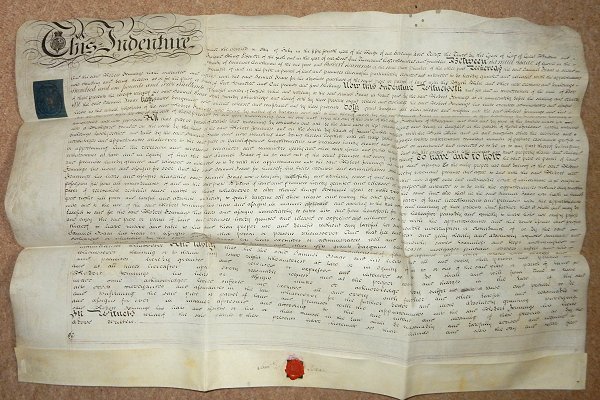
An indenture in my collection dated 2 July 1814 shows Samuel to have sold to Robert Jennings a brickyard for the sum of £201 5s (around £150,000 at today's value) on land to the south of land already owned by Jennings for the "absolute purchase of the same piece or parcel of land with the Brick Kiln and other new erections and buildings now standing and being thereon". The land was described as "All that piece or parcel of arable land containing by estimation one acre.... situate lying and being in Gorefield (Goar Knap) in the parish of Yeovil aforesaid lately converted into a Brickyard bounded on the north by the land of the said Robert Jennings and on the South by lands of James Tucker together with the Brick Kiln and all and singular other outhouse and buildings lately erected and built by the said Samuel Isaac and now standing and being thereon....".
In the 1841 census he is listed living in the farmhouse at Reckleford with an agricultural labourer, John Cheeseman, and a female domestic servant. He was listed in the Poll Book of 1846 by virtue of owning his freehold house and lands in Reckleford. In the 1846 Tithe Apportionment his substantial land holdings were listed, and are tabulated below. Behind his farmhouse was a large three-acre orchard, now occupied by Earle Street but most of his farmlands were to the east of Ryalls Lane (today's Eastland Road) as shown on the maps below.
Samuel died in Yeovil in the summer of 1849. He was aged 66. His brother Thomas, who owned Grove House in Preston Road, inherited the lands on Samuel's death but sold off the estate within six months.
Land Holdings
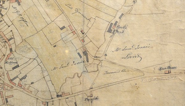
E Watts' map of Yeovil of 1806 (at a slight angle) with Reckleford running from top, left of centre, to join Townsend at lower right, continuing as today's Sherborne Road at lower right by Sun House farm. At centre is Samuel Isaac's farm, later the Glovers Arms, on Reckleford with his lands named to both left and right.
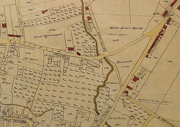
E Watts' map of Yeovil of 1831 shows the large orchard to the south of the farmhouse and flanked on the east by Milford Stream running down the centre of the map. The top right quadrant is marked "Shen's Lower Ryalls (Mr S Isaac)".
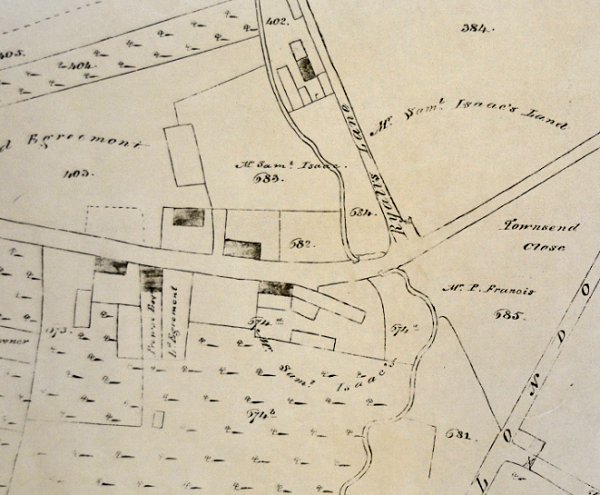
By the time of E Watts' map of Yeovil of 1842 it is evident that Isaac now also owned land to the west of Ryall's Lane (today's Eastland Road).
![]()
The Yeovil Tithe Apportionment of 1846 shows that Samuel Isaac was owner / occupier of extensive land holdings in Yeovil as tabulated below - a total of 47a 2r 1p. His home was the farmhouse, later the Glovers Arms on Reckleford.
| Owner | Occupier | Plot | Parcel Name | Area |
| Isaac, Samuel | Isaac, Samuel | 72 | Farm House, Garden & Yard | 0a 3r 16p |
| Isaac, Samuel | Isaac, Samuel | 73 | Orchard, The | 3a 1r 30p |
| Isaac, Samuel | Isaac, Samuel | 538 | Gold Croft Orchard | 0a 3r 0p |
| Isaac, Samuel | Isaac, Samuel | 997 | Long Close | 5a 2r 0p |
| Isaac, Samuel | Isaac, Samuel | 1009 | Barehills | 4a 1r 37p |
| Isaac, Samuel | Isaac, Samuel | 1012 | Ryalls Lane Orchard | 0a 2r 0p |
| Isaac, Samuel | Isaac, Samuel | 1013 | Little Long Close | 1a 3r 30p |
| Isaac, Samuel | Marsh, Charles | 978 | Sydlings | 2a 3r 32p |
| Isaac, Samuel | Marsh, Charles | 995 | Lower Ryalls | 4a 3r 0p |
| Isaac, Samuel | Marsh, Charles | 999 | Higher Ryalls | 8a 1r 0p |
| Isaac, Samuel | Phelps, Henry Bryant | 530 | Shens Lower Ryalls | 9a 0r 20p |
| Isaac, Samuel | Phelps, Henry Bryant | 533 | Orchard | 0a 2r 24p |
| Isaac, Samuel | Phelps, Henry Bryant | 535 | Orchard | 0a 3r 19p |
| Isaac, Samuel | Phelps, Henry Bryant | 993 | Shens Higher Ryalls | 4a 0r 10p |
| Isaac, Samuel | Symes, William | 570 | In Gold Croft | 0a 3r 29p |
For an explanation of historic Land Measurement - click here.
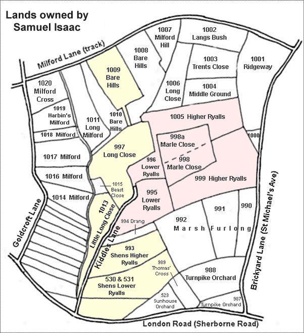
The area shaded pink are the former East Ryalls and West Ryalls leased in 1806, but later owned by, Samuel Isaac. The areas shaded yellow are other parcels owned by him although by 1842 he had sold off Parcels 996 and 1005 to Ann Collins and Parcels 998 and 998a to John Tanner Whiteley Pitcher. Samuel Isaac also owned several other parcels outside this map.
Location Map of the brickyard
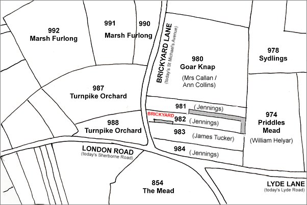
This map, based on the 1842 Tithe Map, shows the parcels of land referred to in the indenture of 1814 above. Parcel 982 was that parcel "lately converted into a Brickyard" by Samuel Isaac, Parcel 981 contained New Prospect Place built and owned by Robert Jennings (his son William had inherited the lands by 1846) - "bounded on the north by the land of the said Robert Jennings". Parcel 983 was "on the South by lands of James Tucker" - this is now the site of Great Western Terrace.
GALLERY
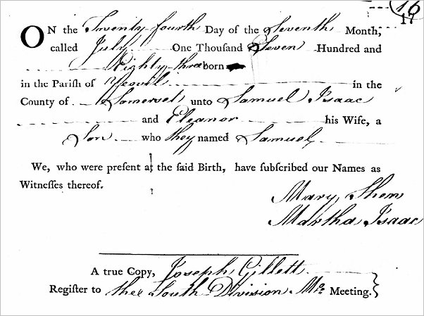
Samuel's entry in the Yeovil Quaker Register of Baptisms.

This colourised photograph
features in my
book 'Yeovil
From Old
Photographs'.
A nice study of the Glovers Arms, the former home of Samuel Isaac. Photographed in the 1960's.
From my
collection
An indenture dated 8 April 1806 in which Samuel Isaac leases East and West Ryalls from John Newman Esq of Barwick. By the 1840s Samuel owned the land outright.
From my
collection
An indenture dated 2 July 1814 in which Samuel Isaac leases the brickyard of Brickyard Lane (today's St Michael's Avenue) to Robert Jennings - plumber & glazier, brickmaker, Postmaster and Portreeve of Yeovil.
From my
collection
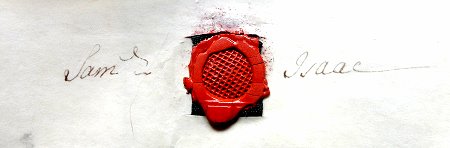
Samuel Isaac's signature and seal on the above indenture of 1814.
From my
collection
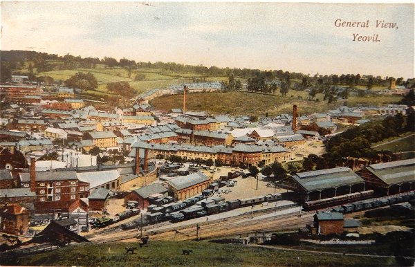
This postcard dates to about 1905 (some fifty years after the death of Samuel Isaac) and shows, at centre, the chimney of the Eastland Road brickworks with its associated buildings clustered around its base. To its left is the leather works built by William Bide (recogniseable by the double roof with a row of six black windows). Running along the bottom of the photograph is Station Road with the Alexandra Hotel at bottom right. In the top half of the photo, Eastland Road runs behind the chimney with fields either side!!! Samuel Isaac owned pretty much all the land between the Eastland Road brickworks chimney at centre and St Michael's church at the far right edge of the postcard.
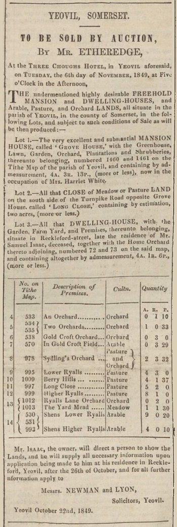
The notice of the sale of Samuel Isaac's lands and properties from the 3 November 1849 edition of the Western Flying Post. Lot 1, Grove House, was in Preston Road and owned by Samuel's brother Thomas and rented to Mrs Harriett White. It is seen in the photograph below. Lot 3 was the family farmhouse on Reckleford, later the Glovers Arms.
From the Cave
Collection
(colourised),
Courtesy of South Somerset Heritage Collection
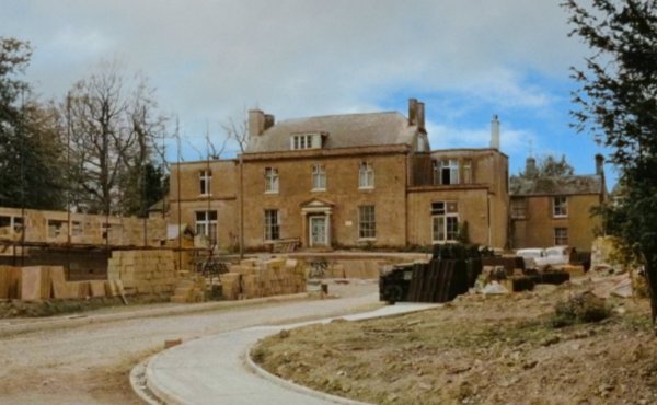
A colourised photograph of Grove House, photographed in the 1960s from Preston Road. The new road is today's Legion Road and at the time Grove House was about to be demolished. It had latterly been used by the British Legion (whose new premises were about to be built on the ground at right in the photograph) and upstairs was the home of the Yeovil Radio Club. In the 1840s it was owned by Thomas Isaac and rented to Mrs Harriett White.