Fore Street
fore street
The medieval fore-way into Yeovil
The area known today as the Triangle but in earlier times called Vennell's Cross, is where Middle Street, South Street, Vicarage Street, Stars Lane and Fore Street (Lower Middle Street) meet and was originally the easternmost point of the Borough of Yeovil.
Since this stretch of road from London Road to the Triangle was the road leading to the town, or the fore-way, it was known as Fore Street from medieval times.
In 1418 the lower part of Middle Street was referred to as 'Forstrete' in a deed thus "Grant by Thomas Harlyng, parson of the church of Yevele, and lord of the town there, to Joan, wife of William, son of Henry Martyn of Yevele and of Joan Henry's wife, and to Cristina daughter of the said William and Joan, for their lives, of the reversion of a messuage and curtilage adjoining, in the street called 'Forstrete' in Yevele, which premises Nicholas Slake, late parson of the same church had demised to the said Henry, Joan his wife, and William their son for their lives. Witnesses:—William Lumbard, provost of the said town, and others (named). 9 October, 5 Henry V".
Where the Rackel Brook and/or Milford Brook crossed Fore Street, as that part of Middle Street from the Triangle to Central Road was known at the time, there was a bridge - mentioned in the 1589 Terrier ".... from Forestreet bridge to Penneway...." and "from thence to Forestreet bridge".
Confusion over the name of this stretch of road began in the nineteenth century when it was called variously Fore Street, Townsend, Middle Street and Lower Middle Street. Technically Townsend was the area from the junction of Reckleford and London Road (today's Sherborne Road) as far as Newton Road, but many people (especially census enumerators) referred to Townsend as reaching as far as the Triangle. Today it is Middle Street from the Borough to Newton Road, although many people refer to this section as Lower Middle Street to differentiate it from the section running from the Borough to the Triangle.
gallery

From my
collection
The north side of Lower Middle Street, close to the Triangle, probably a colourised photograph of 1923 (when Mary Slann was running the Coronation Hotel a few doors along).
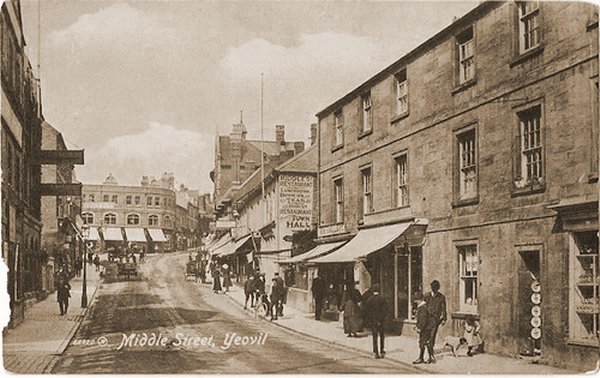
A postcard of around 1912 of Lower Middle Street looking towards the Triangle with the new Co-operative Society building built in 1910. The building at right was Commercial Buildings.
From my
collection
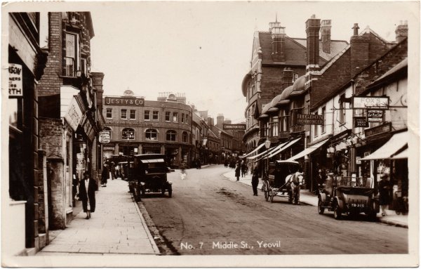
Pretty much the same view, this is a 1940s postcard but the photograph was taken around 1923 when Mary Slann was running the Coronation Hotel. (The Jesty & Co sign is suspended from a building to the left and is not on the Co-op building).
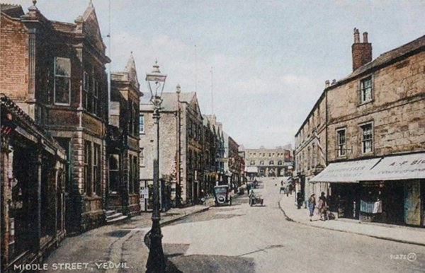
A colourised postcard of the 1930s, taken from outside the Gasworks offices and showroom, looking back towards the Triangle.
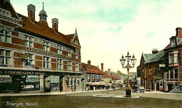
A hand-coloured postcard dating to 1905 and looks down Lower Middle Street from the Triangle. At left is the Coronation Hotel and Vaults and to the right is the large three-light Sugg gas lamp which was removed when the underground toilets were built - the location is now the bandstand.

A photograph of Lower Middle Street, dating to about 1905, shows the Railway Inn at extreme left projecting slightly beyond the terraced building next to it. The photographer is standing roughly outside where the William Dampier is today and looking along the eastern end of Middle Street with Station Road (now Old Station Road) at right. The large building on the junction at right was the Fernleigh Temperance Hotel and is currently an Indian restaurant. This incarnation of the Railway Inn was demolished in 1913 to allow for the construction of Central Road and the new Railway Tavern was built to one side - on the corner now occupied by the William Dampier. The site of this first Railway Tavern is now the end of Central Road (at the traffic lights outside the William Dampier) - see photo below.
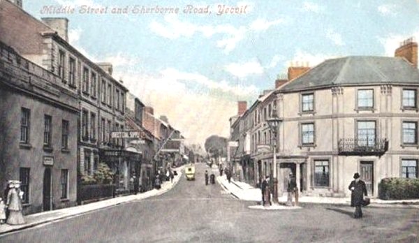
A hand-coloured postcard, taken from the above photograph.
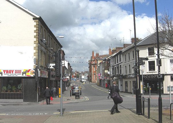
The same view as above but taking in 2012. The original Railway Inn has gone, replaced with Central Road, but the building next to it housing the kebab shop remains, as does the old Fernleigh Temperance Hotel building at right. The frontage of the original Railway Inn, bearing in mind that it projected further towards the road than its neighbours, would have been roughly where the red bag is belonging to the man crossing the road. This particular junction is today ruined by a plethora of street furniture - lights, cameras, traffic lights, signs, etc.
This
colourised photograph
features in my
book 'Yeovil From Old Photographs'.
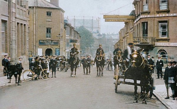
By 1918, the date of this Rendell photograph, the former Western Gazette offices were being used as a Salvation Army Temple. Note the gas holder dominating the view into town.
Photo
(colourised) by Bernard
White. Courtesy of South Somerset Heritage Collection
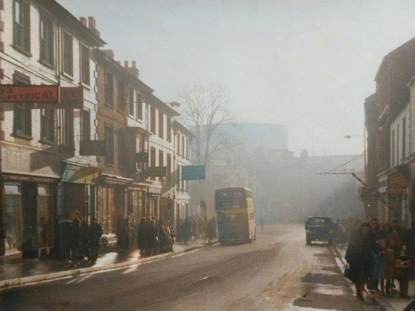
This atmospheric photograph of Lower Middle Street was taken at 4.30pm on 2 February 1952.