Yeovil people
william hooper masters
the Elder and the Younger
As far as is known at present, the progenitor of the Nonconformist Masters family in Yeovil was tailor William Masters the Elder. His son, William Masters the Younger, was born in Yeovil and baptised on 12 September 1733 in the Yeovil Nonconformist chapel.
William the Younger married Elizabeth Hooper (1740-1820), at Montacute on 8 September 1761. Elizabeth was the daughter of William Hooper (1701-1782) and his wife Elizabeth.
William Hooper Masters the Elder, later styled as 'Gentleman', was born in Yeovil in 1771, the son of William Masters the Younger and Elizabeth née Hooper. It is not known if he had any siblings. He became a succesful mercer, or dealer in textile fabrics, owning South Street House (see Gallery) and much land behind it.
In 1790, William inherited a substantial estate from his uncle - see the will of Jonathan Hooper.
On 8 February 1792, William Hooper Masters married Elizabeth Anstice (1771-1849) at Martock. She was the daughter of Josiah Anstice (1724-1807) and Mary née Sylvester (1730-1775). William and Elizabeth were to have eight children, all born in Yeovil, although three died in infancy. The following are from the Yeovil Nonconformist Register of Births -
-
Elizabeth - born 27 March 1793, baptised 26 May 1793. Died 1853 in Paddington, London.
-
William Hooper - born 13 June 1794, baptised 14 October 1795. Died in infancy.
-
Dorcas - born 1 October 1795, baptised 20 February 1797. Died in infancy.
-
Anna - born 21 January 1797, baptised 20 February 1797. Died in infancy.
-
Anna - baptised 29 April 1798.
-
Sarah - born 9 September 1802, baptised 27 October 1802. Married John Brown of Combe St Nicholas in St John's church on 69 May 1823. Lived in Combe St Nicholas, where she had three children. Died there in 1884.
-
William Hooper (the Younger) - born 24 January 1804, baptised 29 February 1804.
Died 1872. -
Jonathan Hooper - born 8 October 1805, baptised 23 November 1805. Became a farmer of 200 acres at Witham Friary, Somerset. Married Grace and had three children. By 1871 Grace had died and he moved to North Cadbury. Died 1875.
Edward Bullock Watts' map of 1806 shows that William and Elizabeth were living at South Street House albeit not named as such on the map, although Masters' name is inscribed against the house and orchard behind it - now the site of Petters Way car park. Two of William's closest friends, who he made executors of his will, were his neighbours; Peter Daniell of Penn House and John Hooper of Hendford Manor.
William Hooper Masters the Elder published his will (see below) on 9 November 1807. He died on Monday 26 September 1808 and his will was proved on 10 March 1809. Elizabeth published her will (see below) in 1844. She died on Monday 18 February 1849, aged 77.
William Hooper Masters the Younger was born in Yeovil on 24 January 1804, the son of merchant William Hooper Masters the Elder and Elizabeth née Anstice. His baptism on 29 February 1804 was recorded in the Yeovil Non-Conformist Register of Births.
Having inherited substantial wealth from his father, by the time of the Jury List in 1827 he was being described as a glover of Back Street (today's South Street).
On 3 January 1828, at Martock, 23-year-old William married 22-year-old Ann Lilly (c1805-1896) by License. The marriage was witnessed by Elizabeth Lilly, Jane Lilly and Ann Anstice. Ann's parents were John Lilly (1770-1823) and Maria née Anstice (1774-1858). William and Ann were to have four children; John Lilly (b1831), Emily Elizabeth (1835-1881), William Hooper the youngest (b1838) and Frederick George (b1845).
William was listed in the poll books of 1832, 1834 and 1846 as living in South Street and being listed by virtue of owning a freehold property in South Street. In Pigot's Directory of 1830 William was listed as a glove manufacturer of South Street and was similarly listed in the Somerset Gazette Directory of 1840 and Slater's Directory of 1852. He was also a member of Yeovil's Vestry.
In 1837 William Hooper Masters, Glove Manufacturer, was listed in a House of Commons Private Bill concerning Railway Subscription Projects, as an investor in the 'South Western, or Kingsworthy & West Monkton Railway', subscribing £3,500 (about £375,000 at today's value using the 'historic opportunity cost' of an investment project).
In the 1841 census William and his wife Ann, originally from Martock, were living in South Street They were recorded with their 10-year-old son listed as Lilly, but in fact was John Lilly, five-year-old Emily, three-year-old William and a female servant. William described his occupation as glove manufacturer.
The 1846 Tithe Apportionment noted that a 'House & Garden' (Parcel 374) and The Orchard (Parcel 375) - South Street House and the orchard behind it - were both owned and occupied by William. The house and garden measured 0a 2r 10p and the orchard measured 3a 0r 0p. He also owned Parcel 371, comprising the whole of the properties on the corner at the junction of Hendford and South Street including the Butcher's Arms. The Apportionment also noted that William owned and occupied a 'Gloving Yard & Garden' (Parcel 461). This was located in Frog Street (today's Addlewell Lane) on the corner of the lane leading to Victoria Buildings and shown on Watts' map of 1831 shown below. The 'Gloving Yard & Garden' measured 0a 1r 39p (for details on historic land measurement - ie acres, roods and perches - click here).
In 1851, William was noted as an investor in the South Western Railway Company.
William gave his occupation as 'Glove Manufacturer, employing 12 men & 4 boys' in the census of 1851. He was still living in South Street with Ann and their three sons; John aged 20 who described his occupation as 'Assistant in Manufactory' and the two younger sons William age 13 and Frederick age 6, both scholars, together with a house servant.
In late November 1854, during the Crimean War, the Yeovil Local Patriotic Fund was created as part of the national scheme to support widows and orphans of servicemen killed in action. Support in Yeovil was instantaneous. A list of subscribers was published in the Western Flying Post's edition of 12 December 1854. On first glance it may seem that people were being less than generous until it is realised the £5 in 1854 would be worth around £600 at today's value. The total amount listed was some £427 - in excess of £50,000 at today's value - and all raised in the first week of the appeal. William subscribed £2 to the fund (around £240 at today's value).
The 1861 census listed William and Ann in South Street with their two sons John and Frederick and a general servant. William listed his occupation as retired glove manufacturer while John, aged 30, listed his as 'late assistant to above' (ie his father) and Frederick, aged 16, was an attorney's clerk. The 1871 census listed just William and Ann, together with a general servant, in South Street. By this time William, who listed his occupation as retired glove manufacturer, was aged 67 and Ann was 66.
William Hooper Masters died at the age of 68, on Tuesday 12 March 1872.
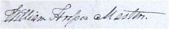
William Hooper Masters the Younger's signature against the Vestry minutes of 3 March 1831.
For the Masters Family Tree - click here.
Maps
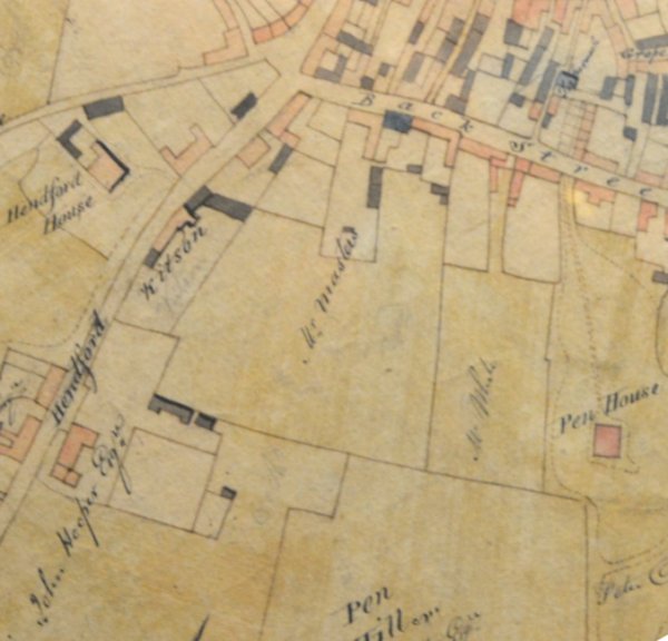
Edward Bullock Watts' map of 1806 showing, at centre, South Street House and its associated land (now occupied by Petters Way car park) owned by William Hooper Masters the Elder. This was inherited by his son, William Hooper Masters the Younger.
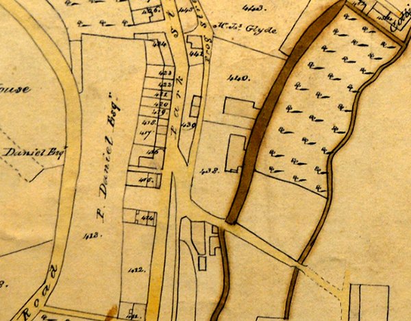
Part of Edward Bullock Watts' map of 1831 showing Park Street running vertically down the centre of the map with Frog Street (Addlewell Lane) running parallel to it. At centre a lane turns towards Victoria Buildings at bottom right. William Hooper Masters' 'Gloving Yard & Garden' (here marked as Parcel 438) is at centre.
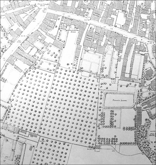
The 1886 Ordnance Survey map shows the extensive orchards owned by William, now covered by Petters Way and the car park. At this time access to the orchards was via a narrow track between South Street House, William's Home, and the Baptist chapel.
Land Holdings
These are the land holdings of William Hooper Masters the Younger, as listed in the 1846 Tithe Apportionment. Parcel 371 'House & Garden' was the corner plot at the junction of South Street and Hendford and included all the buildings including the Butcher's Arms.
|
Owner |
Occupier |
No |
Name |
|
Masters, William Hooper |
Hill, Robert |
46 |
House, Garden & Orchard |
|
Masters, William Hooper |
Raymond, George |
371 |
House & Garden (Butcher's Arms) |
|
Masters, William Hooper |
Masters, William Hooper |
374 |
House & Garden (South St Ho) |
|
Masters, William Hooper |
Masters, William Hooper |
375 |
The Orchard |
|
Masters, William Hooper |
Masters, William Hooper |
461 |
Gloving Yard & Garden |
|
Masters, William Hooper |
Barrett, John |
685 |
Rustywell Close |
|
Masters, William Hooper |
Squire, James |
788 |
Gallery
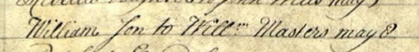
The 8 May 1728 baptism of William Masters, son of William Masters, tailor of Yeovil and the progenitor of the Masters family in Yeovil, from St John's parish register.
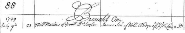
A concatenated entry from the Register of Duties paid for Apprentices in which, on 23 July 1729, William Masters the Elder took on James, son of William Budge of Castle Cary, as an apprentice.
![]()
The record of the 8 February 1792 marriage of William Hooper Masters the Elder and Elizabeth Anstice at Martock, from Phillimore's Somerset Parish Registers: Marriages, Vol III.
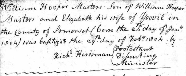
The record of William Hooper Masters the younger's 1804 birth and baptism dates, recorded in the Yeovil Non-Conformist Register of Births.
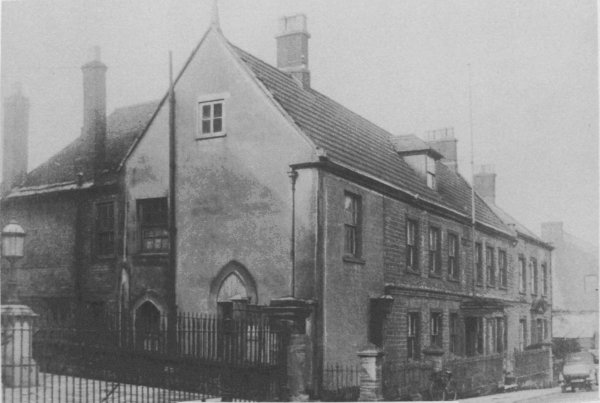
South Street House at 79 South Street - the home of both William Hooper Masters the Elder and William Hooper Masters the Younger. The site is now occupied by the entrance to Petters Way and the Petters Way car park adjoining South Street. The railings at left belong to the Baptist church and at the time of this photograph a narrow lane ran between South Street House and the church, leading originally to William's extensive orchards.
![]()
The notice of the death of William Hooper Masters the Elder in the 3 October 1808 edition of the Salisbury and Winchester Journal.
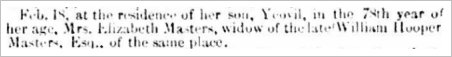
The notice of the death of Elizabeth Masters in the 1 March 1849 edition of the Dorset County Chronicle.
The 1807 will of William Hooper Masters the Elder
This is the last Will
and Testament of me William Hooper Masters of Yeovil in the County of Somerset Gentleman I give and devise all that my
Messuage or
Dwellinghouse
with the
Appurtenances
thereunto
belonging in
Back Street [today's South Street]
in Yeovil
aforesaid now in
the occupation
of my Mother
unto my Dear
Wife Elizabeth
Masters for and
during the term
of her natural
life. Also I
give unto my
said Wife the
whole of my
Plate Linen
China Household
Goods and
Furniture which
shall be in my
dwellinghouse at
the time of my
death for her
own use
absolutely Also
I give and
bequeath unto my
Friends
Peter
Daniell of
Yeovil aforesaid
Esquire [of Penn House] John Hooper of the same place Esquire [of Hendford Manor] and my Brother in Law Samuel Anstice of the Inner Temple London Gentleman
One Guinea each
for Rings Also I
give and
bequeath unto
the said Peter
Daniell John
Hooper and
Samuel Anstice
the Sum of Two
thousand and
five hundred
pounds upon this
special Trust
and confidence
nevertheless
(that is to say)
that they my
said Trustees or
the Survivor of
them or the
Executors or Adm[inistrat]ors
of such Survivor
do and shall as
soon as
convenient after
my death place
the said Two
thousand and
five hundred
pounds upon
Government or
other good and
sufficient
Security in
their own Names
and in such
manner as they
shall think
proper and also
in trust that
they do and
shall receive
the Interest and
Dividends
thereof from
time to time as
the same shall
become payable
and pay and
apply the same
unto my said
Wife and her
Assigns for and
during the term
of her natural
life for her own
use and benefit
and from and
after the
decease of my
said Wife it is
my Will that the
said Two
thousand and
five hundred
pounds with the
Interest
Dividends and
Produce thereof
as shall not
have been
applied as
aforesaid shall
sink into and
become part of
the Residue of
my Estate and
effects
hereinafter
disposed of And
I hereby declare
that the
provision hereby
made and
intended for my
said Wife shall
be taken and
received by her
in addition to
the provision
secured to her
by certain
Articles
Executed
previous to our
Marriage I give
and devise all
my Closes and
Lands in Yeovil
aforesaid and
also my
Dwellinghouse in
Back Street
Subject
nevertheless to
the Estate which
I have given to
my said Wife for
life in my House
in Back Street
as aforesaid and
all other my
Lands and Heredit[ament]s
whatsoever
either in
possession
reversion
remainder or
expectancy of
which I have now
a power to
dispose unto and
to the use of
them the said
Peter Daniell
John Hooper and
Samuel Anstice
their Heirs and
Assigns In trust
nevertheless for
and for the only
benefit of all
and every the
Child and
Children if more
than one of my
body who shall
be living or in
ventre sa
mere [in his
mother's belly]
at the time of
my decease and
afterwards born
alive their
Heirs and
Assigns for Ever
as Tenants in
common and not
as joint Tenants
and if there
shall be but one
Child only then
in trust foir
such only Child
his or her Heirs
and Assigns for
Ever provided
always
nevertheless
that if shall
happen that any
one or more of
my Children now
born or to be
born shall
happen to die
before he she or
they shall
attain his her
or their
respective Ages
of twenty one
Years and
without Issue of
his her or their
body or bodies
living at the
time of his her
or their decease
or deceases or
begotten and
afterwards born
alive then I
give the
respective parts
or shares of the
same lands and
Hereditaments of
such Child or
Children
respectively so
dying unto such
of my Children
as shall survive
such Child or
Children as
shall Die
respectively and
to his her or
their Heirs and
Assigns for Ever
to be equally
divided between
them if more
than one as
Tenants in
common and not
as joint Tenants
and if it shall
happen that All
my said Children
but one shall
happen to die
under Age and
without Issue as
aforesaid then I
give and devise
the respective
Shares or parts
of and in the
same Lands and
Hereditaments of
such Child or
Children
respectively so
dying unto such
only surviving
Child his or her
Heirs and
Assigns for Ever
Provided also
that if it shall
happen that all
my said Children
shall happen to
die under the
Age of twenty
one years and
without having
Issue of his her
or their body or
bodies lawfully
begotten then I
give and devise
all and singular
my said Lands
and
Hereditaments
unto my Wife for
and during the
term of her
natural life and
from and after
her decease I
give and devise
the same Lands
and
Hereditaments
unto all and
every the Child
and Children of
the said John
Hooper their
Heirs and
Assigns for Ever
as Tenants in
common and not
as joint Tenants
I give and
bequeath my Gold
Watch with the
Chain and Seale
I usually wear
unto my Son
William All the
rest residue and
remainder of my
Goods Chattels
Stock in Trade
Estate and
Effects of what
nature or kind
soever not
hereinbefore
given or
bequeathed I
give and
bequeath unto
the said Peter
Daniell John
Hooper and
Samuel Anstice
To hold to them
the said Peter
Daniell John
Hooper and
Samuel Anstice
their Executors
Adm[inistrat]ors
and Assigns upon
this special
trust and
confidence
nevertheless
(that is to say)
that they my
said Trustees or
the Survivors or
Survivor of them
or the Executors
or Adm[inistrat]ors
of such Survivor
do and shall as
soon as
convenient after
my death sell
and dispose
thereof and call
in and receive
all such Debts
Sum and Sums of
Money as shall
be due or owing
to me at the
time of my death
and place the
Monies arising
by such Sale or
Disposal and the
Monies to be so
called in and
received upon
Government or
other good and
sufficient
Security in
their own Names
and in such
manner as they
shall think
proper and also
in trust that
they do and
shall receive
the Interest and
Dividends
thereof from
time to time as
the same shall
become payable
and pay apply
and dispose of
the same or a
sufficient part
thereof for and
towards the
Maintenance
Education
Support and
bringing up of
my Children
Elizabeth Sarah
William Hooper
and Jonathan
Hooper and such
other Child or
Children as I
shall have
living or that
my Wife may be
ensient with at
the time of my
death until my
said Children
shall severally
and respectively
attain their
several and
respective Ages
of twenty one
years in trust
to pay assign
transfer and
convey all the
said Residue of
my Estate and
Effects with the
Interest
Dividends and
Produce thereof
as shall not
have been
applied for and
towards the
Maintenance and
Education of my
Children as
aforesaid
equally unto and
amongst all my
said Children
when and as they
shall severally
and respectively
attain their
said Ages of
twenty one years
and in case any
or either of my
said Children
shall happen to
die before
having attained
twenty one years
of age without
having Issue of
his or her body
lawfully
begotten then In
trust to pay
assign transfer
and convey all
the said residue
of my Estate and
Effects and the
Interest
Dividends and
Produce thereof
or such part
thereof as shall
remain unapplied
as aforesaid
unto such of my
said Children as
shall live to
attain his her
or their
respective Age
or Ages of
twenty one years
Share and Share
alike if more
that one but in
case any or
either of my
said Children
shall happen to
die under Age
leaving Issue of
his her or their
body or bodies
lawfully
begotten then in
trust to pay
assign transfer
and convey the
part or Share of
such Deceased
Child or
Children unto
such his her or
their Issue
Share and Share
alike if more
than one when
and as soon as
they shall
severally and
respectively
attain their
several and
respective Ages
of twenty one
years and to pay
and apply the
Interest
Dividends and
Produce thereof
in the mean time
for and towards
their respective
Maintenance and
Education but in
case all and
every of my said
Children shall
happen to die
under Age and
without having
Issue of his her
or their body or
bodies lawfully
begotten then in
trust to pay the
Interest and
Dividends of the
said Residue of
my Estate and
Effects when and
as the same
shall be
received unto my
said Wife for
and during the
term of her
natural life and
from and after
her decease in
trust to pay
assign transfer
and convey one
thousand pounds
part of the said
Residue of my
Estate and
Effects equally
unto and amongst
all and every
the Children of
my said Brother
in Law Samuel
Anstice One
thousand pounds
further part of
the s[ai]d
Residue of my
Estate and
Effects equally
unto and amongst
all and every
the Children of
my said Brother
in Law John
Anstice One
thousand pounds
further part of
the s[ai]d
Residue of my
Estate and
Effects equally
unto and amongst
all and every
the Children of
my said Brother
in Law William
Anstice One
thousand pounds
further part of
the s[ai]d
Residue of my
Estate and
Effects equally
unto and amongst
all and every
the Children of
Francis Masters
late of Yeovil
aforesaid my
late Uncle
deceased and
also in trust to
pay assign
transfer and
convey the
remaining part
of the said
residue of my
Estate and
Effects equally
unto and amongst
all and every
the Children of
John [Turrell ?]
of Montacute
Farmer by
Elizabeth his
Wife (formerly
Elizabeth
Hooper) And I do
hereby empower
and direct my
said Trustees to
pay assign
transfer and
convey the same
accordingly And
I do hereby
direct that my
said Trustees
shall and may
pay and
reimburse
themselves and
himself out of
the aforesaid
residue of my
Estate and
Effects all
reasonable and
necessary Costs
Charges and
Expenses
whatsoever that
they or either
of them shall or
may bear pay be
put unto or
sustain in or
about the
Execution of
this my Will or
the Trust hereby
in them reposed
And lastly I do
hereby nominate
constitute and
appoint my said
Trustees the
said Peter Daniell, John Hooper and
Samuel Anstice
Executors of this my last Will and
Testament And I
do also nominate
constitute and
appoint my said
Wife so long as
she shall
continue my
Widow and no
longer together
with my said
Trustees
Guardian of my
aforesaid
Children
Elizabeth Sarah
William Hooper
and Jonathan
Hooper and all
and every such
other Child or
Children as I
shall have
living or that
my said Wife may
be Ensient with
at the time of
my death and do
hereby revoke
and make void
all former and
other Will and
Wills by me at
any time
heretofore made
and do declare
this to be my
last Will and
Testament.
In Witness whereof I have at the bottom of the first three first Sheets of this my
Will the whole
whereof is
contained in
four Sheets of
paper subscribed
my name and to
this fourth and
last Sheet my
hand and Seal
the ninth Day of
November in the
Year of our Lord
One thousand
Eight hundred
and Seven
W Hooper Masters
Signed Sealed and published by the said William Hooper Masters as and for
his last Will
and testament in
the presence of
us who at his
request in his
presence and in
the presence of
each other have
subscribed our
Names as
Witnesses
Samuel Walter Tracey
Will[ia]m
Cayme
Rob[er]t
Cayme
This Will was proved at London on the tenth Day of March in the Year of our Lord One
thousand Eight
hundred and nine
before the Right
Honourable Sir
John Michell
Knight Doctor of
Laws Master
Keeper or
Commissary of
the Prerogative
Court of
Canterbury
lawfully
constituted by
the Oaths of
Peter Daniell,
John Hooper and
Samuel Anstice
Esquires the
Executors named
in the said Will
to whom
Administration
was granted of
all and Singular
the Goods
Chattels and
Credits of the
Deceased they
having been
first sworn by
Commission duly
to Administer
Transcribed by Bob Osborn
The 1844 will of elizabeth Masters née Anstice
This is the last Will and Testament
of me Elizabeth Masters
now or late of Yeovil in the County of Somerset Widow Whereas in and by
certain Articles
of Agreement
made on my
marriage with my
deceased husband
William Hooper
Masters
Gentleman
bearing date the
seventh day of
February one
thousand seven
hundred and
ninety two it
was amongst
other things
agreed that the
sum of five
hundred pounds
therein
covenanted to be
paid within six
months next
after the
decease of James
Patten therein
named unto
Samuel Anstice
and John Hookins
therein also
respectively
named should
from after the
death of the
survivor of the
said William
Hooper Masters
and myself in
case there
should be any
child or
children of the
said intended
marriage then
living be paid
and applied by
the said Samuel
Anstice and John
Hookins and the
survivor of them
his executors
and
administrators
unto the child
if but one or
unto and amongst
all the children
if more than one
of the said
intended
marriage in such
parts shares and
proportions at
such time and
times and in
such manner as I
by any Deed or
Instrument in
writing under my
hand and seal
executed in the
presence of and
attested by two
or more reliable
witnesses or by
my last Will and
Testament in
writing or any
writing
purporting so to
be executed and
attested as
aforesaid should
give direct
limit or appoint
the same Now in
exercise and
execution of the
said power or
authority so
given or
reserved to me
as aforesaid and
of every other
power and
authority
enabling me in
this behalf I do
by this my last
Will and
Testament under
my hand and seal
executed in the
presence of and
attested by two
or more credible
witnesses whose
names are
intended to be
signed hereto as
Witnesses
attesting the
same give and
bequeath direct
and appoint the
said sum of five
hundred pounds
in manner
following that
is to say my son
Jonathan Hooper
Masters being
one of the
children of the
said marriage
the sum of ten
pounds part
thereof to my
daughter
Elizabeth Porter
wife of Edward
Porter of
Somerton in the
County of
Somerset
Gentleman being
one other of the
children of the
said marriage
the sum of ten
pounds part
thereof to my
daughter Sarah
Brown wife of
John Brown of
Combe Saint
Nicholas in the
said County of
Somerset
Clothier being
one other of the
children of the
said marriage
the sum of ten
pounds part
thereof and the
remaining sum of
four hundred and
seventy pounds I
give bequeath
direct and
appoint unto my
said son William
Hooper Masters
the other child
of the said
marriage and I
wish it to be
understood that
my reason for
giving the sum
of ten pounds
only to my said
son Jonathan
Hooper Masters
is because I
conceive the
provision made
for him by the
settlement made
on my marriage
and that which
was made for him
on his own or
otherwise is
fully equal to
the provision I
make for my
other children I
give and
bequeath to my
said son William
Hooper Masters
and my Grandson
William Masters
Porter the sum
of one thousand
and two hundred
pounds Upon
trust that they
or the survivor
of them or the
executors or
administrators
of such survivor
do and shall
place the same
upon Government
or real or other
good and
sufficient
security or
securities in
their own names
and in such
manner as they
shall think
proper and also
upon trust that
they do and
shall transfer
pay apply and
dispose of the
said sum of one
thousand and two
hundred pounds
or any part or
parts thereof
unto and amongst
all and every or
such one or more
of the children
of my said
daughter
Elizabeth Porter
now born or
hereafter to be
born except the
said William
Masters Porter
in such parts
shares and
proportions at
such time or
times and in
such manner and
form as she the
said Elizabeth
Porter shall
notwithstanding
her present or
any future
coverture and
whether she
shall be covert
or sole by any
deed or deeds
installment or
installments in
writing with or
without power of
revocation to be
duly executed by
her in the
presence of and
attested by two
or more credible
witnesses or by
her last Will
and Testament in
writing or by
any writing
purporting to be
executed and
attested as
aforesaid give
direct limit or
appoint the same
And in default
and until such
gift direction
limitation or
appointment and
so far as every
or any such gift
direction
limitation or
appointment
shall not extend
upon trust that
my said trustees
do and shall
receive the
interest and
dividends of the
said sum of one
thousand and two
hundred pounds
from time to
time as the same
shall become
payable and pay
apply and
dispose of the
same unto or for
the use of my
said daughter
Elizabeth Porter
for and during
the term of her
natural life and
from and after
her decease Upon
trust that my
said trustees do
and shall
receive the
interest and
dividends of the
said sum of one
thousand and two
hundred pounds
or of so much
thereof as shall
then remain
undisposed of as
the same shall
become payable
and pay apply
and dispose of
the same into
the hands of the
said Edward
Porter or
otherwise as my
said trustees
shall think
proper for and
towards the
maintenance
education
support and
bringing up of
the children of
my said daughter
Elizabeth Porter
except the said
William Masters
Porter who shall
be living at the
time of her
death until they
shall severally
and respectively
attain their
several and
respective ages
of twenty one
years and when
and as they
shall severally
and respectively
attain their
said ages of
twenty one years
in trust to pay
the said sum of
one thousand and
two hundred
pounds or of so
much thereof as
shall then
remain
undisposed of
with the
interest
dividends and
produce thereof
that shall not
have been
applied as
aforesaid
equally unto and
amongst all the
children of my
said daughter
Elizabeth Porter
except the said
William Masters
Porter when and
as they shall
severally and
respectively
attain their
said ages of
twenty one years
and in case any
or either of the
same children of
my said daughter
Elizabeth Porter
shall happen to
die before
having attained
twenty one years
of age then in
trust to pay the
said sum of one
thousand and two
hundred pounds
or such part
thereof as shall
then remain
undisposed of
and the interest
and dividends
thereof or such
part thereof as
shall remain
unapplied as
aforesaid unto
such of the same
children of my
said daughter
Elizabeth Porter
as shall live to
attain his her
or their age or
respective ages
of twenty one
years if more
than one share
and share alike
but in case all
and every of the
same children of
my said daughter
Elizabeth Porter
shall happen to
die under the
age of twenty
one years then
in trust to pay
the said sum of
one thousand and
two hundred
pounds or such
part thereof as
shall then
remain
undisposed and
the interest and
dividends
thereof or such
part thereof as
shall remain
unapplied as
aforesaid unto
and equally
between such
person or
persons as would
have been the
personal
representative
or
representatives
of my said
daughter
Elizabeth Porter
in case she had
died died [sic]
sole and
unmarried and
intestate I give
and bequeath
unto my said son
William Hooper
Masters and my
said Grandson
William Masters
Porter the
further sum of
one thousand and
one hundred
pounds upon
trust that they
or the survivor
of them or the
executors or
administrators
of such survivor
do and shall
place the same
upon Government
or real or other
good and
sufficient
security or
securities in
their own names
and in such
manner as they
shall think
proper and also
upon trust that
they do and
shall transfer
pay apply and
dispose of the
said sum of one
thousand and one
hundred pounds
or any part or
parts thereof
unto and amongst
all and every of
such one or more
of the children
of my said
daughter Sarah
Brown now born
or hereafter to
be born in such
parts shares and
proportions at
such time or
times and in
such manner and
form as she the
said Sarah Brown
shall
notwithstanding
her present or
any future
coverture and
whether she
shall be covert
or sole by any
deed or deeds
installment or
installments in
writing with or
without power of
revocation to be
duly executed by
her in the
presence of and
attested by two
or more credible
witnesses or by
her last Will
and Testament in
writing or by
any writing
purporting to be
executed and
attested as
aforesaid give
direct limit or
appoint the same
and in default
of and until
such gift
direction
limitation or
appointment and
so far as every
or any such gift
direction
limitation or
appointment
shall not extend
upon trust that
my said trustees
do and shall
receive the
interest and
dividends of the
said sum of one
thousand and one
hundred pounds
from time to
time as the same
shall become
payable and pay
apply and
dispose of the
same unto or for
the use of my
said daughter
Sarah Brown for
and during the
term of her
natural life and
from and after
her decease Upon
trust that my
said trustees do
and shall
receive the
interest and
dividends of the
said sum of one
thousand and one
hundred pounds
or of so much
thereof as shall
then remain
undisposed of as
the same shall
become payable
and pay apply
and dispose of
the same into
the hands of the
said John Brown
or otherwise as
my said trustees
shall think
proper for and
towards the
maintenance and
education
support and
bringing up of
the children of
my said daughter
Sarah Brown who
shall be living
at the time of
her death until
they shall
severally and
respectively
attain their
several and
respective ages
of twenty one
years and when
and as they
shall severally
and respectively
attain their
several and
respective ages
of twenty one
years In trust
to pay the said
sum of one
thousand and one
hundred pounds
or of so much
thereof as shall
then remain
undisposed of
with the
interest
dividends and
produce thereof
that shall not
have been
applied as
aforesaid
equally unto and
amongst all the
children of my
said daughter
Sarah Brown when
and as they
shall severally
and respectively
attain their
said ages of
twenty one years
and in case any
or either of the
said children of
my said daughter
Sarah Brown
shall happen to
die before
having attained
twenty one years
of age then in
trust to pay the
said sum of one
thousand and one
hundred pounds
or so much
thereof as shall
then remain
undisposed of
and the interest
and dividends
thereof or such
part thereof as
shall remain
unapplied as
aforesaid unto
such of the
children of my
said daughter
Sarah Brown as
shall live to
attain his her
or their age or
respective ages
of twenty one
years if more
than one share
and share alike
but in case all
and every of the
children of my
said daughter
Sarah Brown
shall happen to
die under the
said age of
twenty one years
then in trust to
pay the said sum
of one thousand
and one hundred
pounds or such
part thereof as
shall then
remain
undisposed and
the interest and
dividends
thereof or such
part thereof as
shall remain
unapplied as
aforesaid unto
and equally
between such
person or
persons as would
have been the
personal
representative
or
representatives
of my said
daughter Sarah
Brown in case
she had died
sole and
unmarried and
intestate I give
and bequeath to
my said daughter
Elizabeth Porter
all my wearing
apparel I give
to the said
William Masters
Porter the sum
of one hundred
and fifty pounds
All the
rest residue and
remainder
of my goods chattels ready money
securities for
money and
personal estate
and effects
whatsoever and
wheresoever not
hereinbefore
disposed of I
give and
bequeath unto my
said son William
Hooper Masters
his executors
administrators
and assigns And
I do hereby
authorize and
empower the said
William Hooper
Masters and
William Masters
Porter and each
of them their
and each of
their executors
and
administrators
from time to
time as often as
they shall think
proper to alter
and change the
securities on
which the said
trust monies or
any part thereof
shall happen to
be placed out
and from time to
time as often as
they shall think
fit again to
place the same
upon Government
or real or such
other good and
sufficient
security or
securities as
they shall think
proper and it is
my Will that
they shall each
be answerable
for their own
acts only and
that they shall
not be
answerable for
more money than
they shall
actually receive
nor for any loss
that may happen
to the said
trust monies or
any part thereof
unless such loss
happen from
their wilful
neglect and they
shall
respectively
have power to
reimburse
themselves all
loss costs
charges damages
and expences
which they shall
respectively
sustain incur or
be put unto in
the execution of
the trusts
hereby reposed
in them and
lastly I do
hereby nominate
constitute and
appoint my said
son William
Hooper Masters
whole and sole
Executor of this my last Will and Testament In Witness whereof I have to this my said
Will subscribed
and set my hand
and seal that is
to say to the
first five
sheets thereof
my hand and to
this sixth and
last sheet my
hand and seal
the twelfth day
of January in
the year of our
Lord one
thousand eight
hundred and
forty four
Elizabeth Masters
Signed sealed published and declared by the said Elizabeth Masters the
Testatrix as and
for her last
Will and
Testament in the
presence of us
who at her
request in her
presence and in
the presence of
each other have
subscribed our
names as
Witnesses
thereto
John Leach
Northcote Wm
Spicer
Proved at London 28th April 1849 before the Worshipful William Robinson Doctor of
Laws and
Surrogate by the
Oath of William
Hooper Masters
the Son the sole
Executor to whom
Adm[inistrati]on
was granted
having been
first sworn duly
to administer
Transcribed by Bob Osborn