Priddle's Mead
PridDle's Mead
Remnant of the medieval common field called Hewish Field
The great medieval field called Northover (see first map below) was later broken up and part of it became a large common field called Hewish, or Hewish Field, stretching from Ram Park in the north, the boundary with the parish of Preston Plucknett in the west, today's West Hendford in the south and roughly as far as today's Clarence Street in the east. The parcels comprising the former great common field called Hewish Field are shown shaded green in the 1842 Tithe Map below.
The name Huish, in its various spellings through time, derives from the Old English 'hiwisc' meaning a household.
On 1 July 1415 Thomas, Earl of Arundel, granted the advowson of Yeovil Rectory to Henry V with "two acres in the field called Huysh".
It was recorded that in 1611 St Leonard's Fair for rother cattle was held in "the field called Huishe in Hendford" - in this instance Hendford being the Manor of Hendford, not the road of that name. As a sidenote; the word 'rother' is an old Anglo-Saxon word for cattle. The rother cattle were long-horned, fleshy beasts prized for their meat, milk, hide and horn (see photo here).
An indenture of 1715 remarks on six acres of arable land "lying in a common field called Hewish in the tything of Hinford.... lately enclosed" - the words 'lately enclosed' being a good indication of when this common field began to be parcelled up. By the 1750s the division parcels of Hewish Field were more or less finalised as shown in the 1842 Tithe Map below.
One of these division parcels of the former common field was Priddle's Mead (Parcel 611). The word 'mead' comes from the Old English 'maed'. Before grass seeds were obtainable this was the only hay land of the community. It usually consisted of land near streams since that was the only kind of land on which hay grew in any quantity. Indeed, Priddle's Mead ran alongside a small stream that later runs into Dodham Brook.
Like nearby Priddle's Orchard (Parcel 606) it is very likely that Priddle's Mead belonged to Henry Peddle, Portreeve of Yeovil between 1741 and 1751 - Priddle's Mead is therefore likely a corruption of 'Peddle'). It was probably devised to his son, William Peddle, a tanner of Yeovil, in his father's will of 1760.
The 1846 Tithe Apportionment recorded that Priddle's Mead measured 1a 1r 22p and was used as meadow - signifying grassland mown annually in the summer for making hay. It was noted in the Apportionment that Priddle's Mead was owned by Jane Newman (widow of John Newman) and occupied by Berkley Newman at this time. In his will of 1844 John Newman referred to Priddle's Mead as "my Orchard in Huish which I lately purchased of the Reverend Henry Peter Daniell and the Close of Meadow Ground thereto adjoining". The orchard was Parcel 609 (Daniell's Orchard) and the close of meadow was Parcel 611 (Priddle's Mead).
Priddle's Mead was bounded on the north by Seward's Close (Parcel 610), Daniell's Orchard (Parcel 609) and a small field with cottages (Parcel 608 - owned and occupied by George Hallett), to the west by the small stream mentioned above, to the south by Leache's Mead (Parcel 312) and Hibbard's Orchard (Parcel 310) and by Priddle's Orchard (Parcel 606) to the east.
The former Priddle's Mead now contains the northern end of Beer Street - a development started along the very edge of the municipal boundary in the late 1890s by local businessman, town councillor and local 'character' Levi Beer. He, of course, named Beer Street after himself.
For details on historic land measurement (ie acres, roods and perches) click here.
maps

This map, based on the descriptions in the 1589 Terrier and the 1846 Tithe Map of Yeovil shows the approximate boundaries of the Manors of Kingston and Hendford as well as the manorial three-field system used in Kingston.
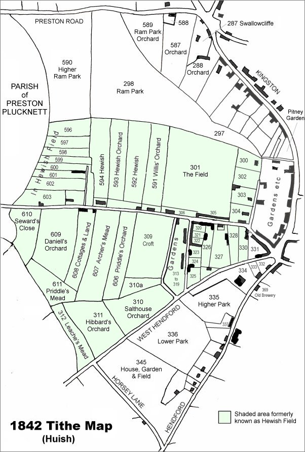
This map is based on the 1842 Tithe Map with field names added from the 1846 Tithe Award. The area shaded light green was originally a large common field called Hewish Field that had been formed out of the earlier medieval field called Northover. By the time of the 1842 Tithe Map, shown here, Hewish Field had been further sub-divided into many parcels as shown.
Priddle's Mead is at left, below centre.
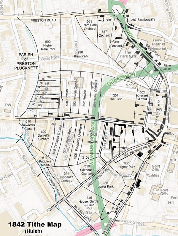
The 1842 Tithe Map superimposed (roughly) over a modern street map showing where several modern roads, for example the rear gardens of the eastern side of Grove Avenue, follow former field boundaries.