Priddle's Orchard / Huish Orchard (2)
Priddle's / Huish Orchard (2)
Once part of the great medieval field called Northover
Priddle's Orchard was once part of the great medieval field called Northover (see first map below). Northover itself was later broken up and part of it became a large common field called Hewish, or Hewish Field, stretching from Ram Park in the north, the boundary with the parish of Preston Plucknett in the west, today's West Hendford in the south and roughly as far as today's Clarence Street in the east. The parcels comprising the former great Hewish Field are shown shaded green in the 1842 Tithe Map below.
The name Huish, in its various spellings through time, derives from the Old English 'hiwisc' meaning a household.
On 1 July 1415 Thomas, Earl of Arundel, granted the advowson of Yeovil Rectory to Henry V with "two acres in the field called Huysh".
It was recorded that in 1611 St Leonard's Fair for rother cattle was held in "the field called Huishe in Hendford" - in this instance Hendford being the Manor of Hendford, not the road of that name. As a sidenote; the word 'rother' is an old Anglo-Saxon word for cattle. The rother cattle were long-horned, fleshy beasts prized for their meat, milk, hide and horn (see photo below).
An indenture of 1715 remarks on six acres of arable land "lying in a common field called Hewish in the tything of Hinford.... lately enclosed" - the words 'lately enclosed' being a good indication of when this common field began to be parcelled up.
Priddle's Orchard was certainly a separate entity by the 1750s and belonged to a Mr Peddle (most likely Henry Peddle, Portreeve of Yeovil between 1741 and 1751 - Priddle's Orchard is therefore likely a corruption of 'Peddle'). It was devised to his son, William Peddle, a tanner of Yeovil, in his father's will of 1760.
In 1785, and by this time known as Huish Orchard (Parcel 606), it was sold to widow Mrs Jane Newman of Yeovil. It then passed to John Newman. By the time of the 1846 Tithe Apportionment Huish Orchard (one of two of that name, the other being the other side of Huish) was in the ownership of Jane Newman (the widow of John, who had died in 1844) and the tenant was Berkley Newman. The Apportionment reckoned the area of Huish Orchard to be 1a 1r 22p. In his will of 1844 John Newman referred to Huish Orchard as "Priddle's Orchard".
Huish Orchard was bounded on the north by Huish, on the west by Archer's Mead (Parcel 607), to the south by Salthouse Orchard (Parcels 310 and 310a) and to the east by Croft (Parcel 309).
It remained in the Newman family until 1871 when it was conveyed to innkeeper John Corrie of Yeovil, who ran the Mermaid Hotel from around 1860 until around 1886. The Mermaid had its own brewhouse so it is likely that cider was made there using the apples from the orchard. Corrie's widow, Elizabeth, sold Huish Orchard in 1906 to Charles Pitcher, landlord of the Mermaid Hotel from about 1901 to 1914.
In the late 1930s Richmond Road was constructed in Archer's Mead, along the eastern boundary of Huish Orchard but houses on the eastern side of Richmond Road were not to be built on Huish Orchard until after the Second World War.
During the war the bulk of the former orchard was used as a temporary wartime army depot and eight Nissen huts are visible on the 1946 aerial photograph below. Note too the zig-zag trench to the north of the huts - this was used as an emergency shelter in times of air raids. The white field to the right is Fairfield which the army used as a transport depot during the war.
After the war the temporary army camp was removed and the remainder of the houses along the eastern side of Richmond Road were built on the former Huish Orchard.
For details on historic land measurement (ie acres, roods and perches) click here.
maps

This map, based on the descriptions in the 1589 Terrier and the 1846 Tithe Map of Yeovil shows the approximate boundaries of the Manors of Kingston and Hendford as well as the manorial three-field system used in Kingston.
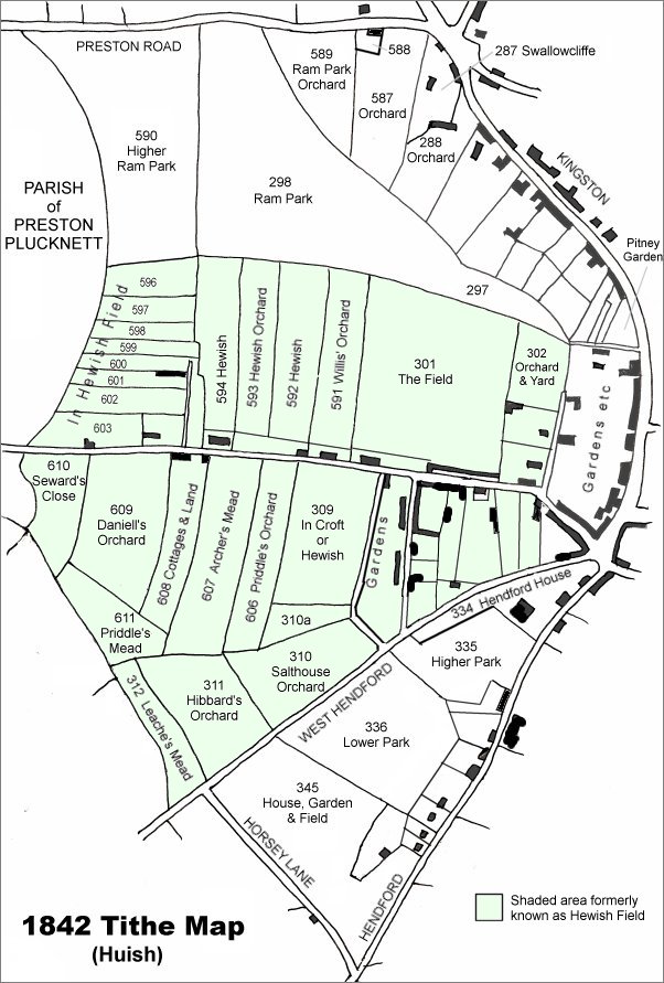
This map is based on the 1842 Tithe Map with field names added from the 1846 Tithe Award. The area shaded light green was originally a large common field called Hewish Field that had been formed out of the earlier medieval field called Northover. By the time of the 1842 Tithe Map, shown here, Hewish Field had been further sub-divided into many parcels as shown.
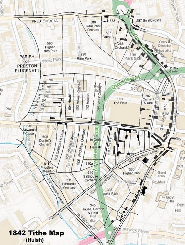
The 1842 Tithe Map superimposed (roughly) over a modern street map showing where several modern roads, for example the rear gardens of the eastern side of Grove Avenue, follow former field boundaries.
Gallery
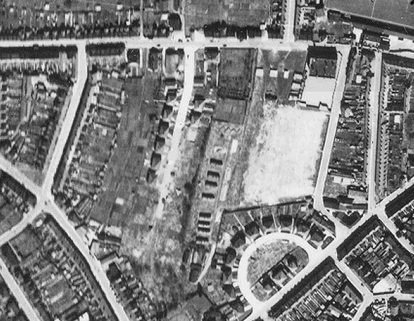
The 1946 aerial photograph clearly shows Huish running along the top and West Hendford and the Crescent at bottom right. The former Priddle's Orchard is at centre. By this time Richmond Road had been built along its western boundary and a couple of houses built at the north of Richmond Road on the eastern side - these were on the former Archer's Mead (Parcel 607). The top right corner of Priddle's Orchard still seemed to be a small field but the bulk of the former orchard was, at this time, still filled with the remains of the temporary wartime army depot and eight Nissen huts are visible. Note too the zig-zag trench to the north of the huts - this was used as an emergency shelter in times of air raids. The white field to the right is Fairfield which the army used as a transport depot during the war. To the top of Fairfield are six air raid shelters - those at left were for the army, the three at right were for the use of the schoolchildren of Huish school.
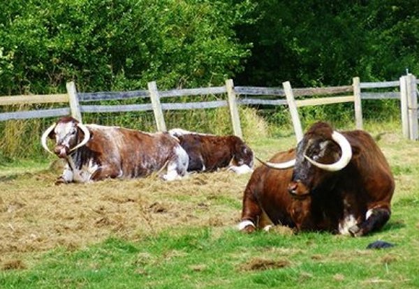
.... and just in case you wanted to know what the dying breed of rother cattle looked like.