Yeovil cemetery
Yeovil cemetery
off Preston Road
Legislation, having regard to the sanitary condition of the people, decreed that after certain periods, some churches and churchyards should be closed against any further interments. Following an order to close the burial ground of St John's church, a Vestry meeting was held on 7 June 1858 at which the Town Council were authorised to expend a sum not exceeding £4,000 (something in excess of £4 million at today's value) for the purchase of land for a new cemetery for the town and providing chapels and a lodge.
The land purchased, lying immediately north of Preston Lane (today's Preston Road), was five acres in total; four to be used immediately and a fifth to be held in reserve. The land used in the first instance was a field split into two parcels called West Field (Parcels 1466 and 1466a) - the name being a hangover from the great medieval West Field of Kingston Manor of which the purchased field had originally formed a small part. The cemetery was to be extended northwards by 1928 by purchasing a further field - Brice's Orchard (Parcel 1434) and a small part of Long Ground (Parcel 1436).
During 1939 negotiations took place to acquire another field - this was Little Hide (Parcel 1435) - to extend the cemetery northwards yet again. The owner of the field, Mr F Brown, was demanding the sum of £300 even though the then-current value was £50 - as a result the negotiations floundered somewhat. The field was eventually acquired to extend the cemetery once more.
The cemetery lodge and two chapels were designed by Robert Howard Shout, an architect of Yeovil and London.
On 7 August 1860 the Western Gazette reported on the financial aspects of creating the new cemetery were progressing as follows "The first item was the purchase money of the land, and interest, £1,106 15s 1d; the vendors solicitors costs, which were payable under the Act of Parliament, were £24 8s 10d; tenant's compensation, £19 10s; making together, £1,150 13s 11d. The contract for the chapels came to £1,866. The contract for walls and fencing was £423 15s; levelling and forming paths, £137; turfing and planting, £70; additional expense of walling a small plot of ground, not quite £10; making for the ground £640 15s. Here he should state that, as regarded the land, the parish had great reason to congratulate themselves upon having purchased such an excellent site and so large an acreage, for the amount. It was a most liberal purchase, and one most desirable for the parish in every way.... The contract, he should explain, provided that the work should be completed by 1 November 1859; but the contractor failed to perform it; and notice was therefore given to him that the expense of the clerk of the works, from that date, would be deducted from the contract.
Mr Batten continued. He now came to the erection of the Lodge; and they certainly calculated that they should have been unable to build a lodge suitable in every respect for the purpose for £300 or £350. They advertised the contracts, got Mr Shout to draw out several plans, reduced the building to its smallest dimensions, but they found that they could not get a lodge erected of a neat and proper appearance suitable for the entrance to such a cemetery, or at all in accordance with the chapels, for anything like that sum. Many of the estimates were upwards of £700 and it was only after considerable difficulty and discussion with Mr Wellspring, the contractor, that they were able to bring down the amount to £608 10s.
Mr Mayo said, before deciding to sell the land, it would be well to ascertain what number of burials could be made in the present ground. There could only be 1200 buried in an acre. There were five acres, but four only were bought in and the other was in reserve. Taking another acre for the buildings, there was land enough to bury 3600. The number buried in Yeovil was, he understood, 300 a year; and according to that calculation, in 12 years their present ground would be filled."
The cemetery was consecrated in September 1860. Of the twin mortuary chapels, the eastern chapel was consecrated for the use of Church of England use while the western mortuary chapel remained unconsecrated for use by Non-Conformists.
The following descriptive report is taken from the 18 September 1860 edition of the Western Gazette -
"The chapels of the cemetery are in the Lombardic style of architecture and consist each of a nave and an apse on the southern side, with entrance and vestibules on the north and an open porch on the west of the consecrated and east of the unconsecrated building. These porches were designed to have been approached from a central tower, the foundations for which were laid, but the funds did not admit of its being carried into execution. The windows are three in each chapel, and are of two lights. There are two single-light windows in the nave to the south, one on either side of the apse. The northern windows of the nave are also two and the vestibules are lighted by a window on each side. The eastern window of the consecrated, and western of the unconsecrated chapels, are exceedingly beautiful and consist each of four lights separated by three elegantly wrought shafts, with carved capitals, and surmounted by a wheel. The windows are all executed in the finest description of Ham Hill stone and are of admirable workmanship; the carvings especially are wrought with the utmost delicacy, a task of no little difficulty, and which, had stone of the coarse quality been employed, could hardly have been performed. In the eastern window the capitals which surmount the two larger shafts are carved externally with the symbols of St Matthew and St John (the angel and the eagle) with ivy and maple leaves underneath; the capital of the central shaft is carved with passionflower leaves. The capitals of the western window (in the unconsecrated building), represent the symbols of the two other evangelists, St Mark and St Luke, (the lion and the bull) with foliage beneath....
There is a central turret to each chapel, about 23 feet high, and built of Ham Hill stone. The lower part of each turret forms a square, the windows of which are filled with stone tracery, and have carved capitals. Above this four gables, supporting a small square, worked with quatrefoils, over which are four smaller gables, from which the spire (removed during the twentieth century) commences to diminish, terminating in a handsome finial. The gables of the nave, porch and vestibules are surmounted by elegant crosses and a handsome gilt cross rises from each apse. Over the entrances to the chapels crosses are represented with the Greek letters alpha and omega.
In the interior one of the chief features which strikes the eye is the novel and very skillful method in which the roof is supported. There are four handsome Ham Hill stone pillars with splendidly carved capitals. From these rise stone ribs, intersecting each other diagonally and sustaining smaller stone ribs, which also intersect, and on which the turret rests. The carvings of the four capitals represent the celestial crown with cross and 'IHS', the bishop's mitre with Italian foliage, the crozier for the lamb and flag (emblem of St John), the Phoenix and the butterfly (emblematic of the soul in eternity). The carvings on the capitals in the on consecrated chapel represent the Maltese cross, foliage, the crown of thorns and 'IHS'.
The windows are filled with patterns of party-coloured glass, supplied by Messrs Powell and Cole. The paving consists of ornamental tiles, furnished by the Poole Architectural Pottery Company, and inlaid in stone.
The chapels accommodate about 50 or 60 persons each. The dimensions are as follows – nave 30ft x 16ft, apse 16ft x 9ft 6in, porch 12ft x 9ft, vestibule or northern entrance, 11ft 6in by 9ft 6in, height to the top of the roof 27ft 6in, to the summit of the spire, 50 feet. The stone employed is partly Ham Hill and partly from the Pillsbury quarries, near Langport. The architect was Mr R H Shout of London and Yeovil, and to him the highest praise is due for the great elegance of the designs. The contractor was Mr Wellspring of Dorchester.
The carvings were supplied by Mr Thomas Phifflers of London, and wrought for him by Mr Henry Burge of the same city. The contract for erecting the chapels amounted to £1,866. There are five acres of ground enclosed, which are surrounded by stone boundary walls. Four acres are intended for present purposes.
A handsome gateway is placed at the entrance with a lodge, not yet finished, but which will be completed in about a fortnight. This is also built by Mr Wellspring. The paths and slopes have been neatly laid out by Mr Baker of Yeovil, and the planting is being performed by Mr Scott of the Preston and Merriott nurseries, in a very tasteful and admirable manner."
The twin mortuary chapels, the lodge, cemetery gates, gate piers and boundary walls are all Grade II Listed Buildings.
MAPs & Aerial Photographs
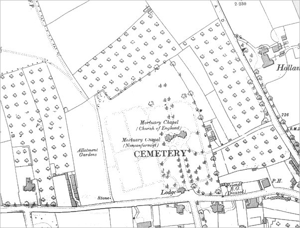
Map based on the 1901 Ordnance Survey showing that at this time the cemetery had not expanded beyond its original limits. By 1928 Brice's Orchard at centre top had the cemetery extended into it.
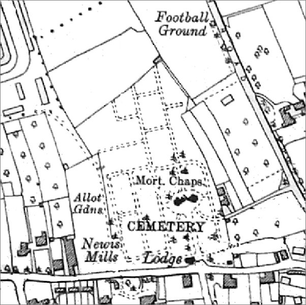
Map based on the 1938 Ordnance Survey showing that the cemetery had been extended into the former Brice's Orchard that had been in the original land purchase. After the Second World War the cemetery would be extended yet again into the next field to the north, Little Hide.
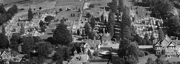
Part of Yeovil Cemetery photographed in 1928. Preston Road runs across the bottom of the photograph and the Cemetery Lodge is seen right of centre with the two chapels towards the top, right of centre.
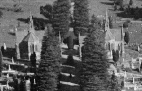
An enlargement of the previous photograph showing the chapels complete with spires - which are now removed. The eastern chapel (at right in the photograph) was consecrated for the Church of England while the western chapel remained unconsecrated for the use of Non-Conformists.
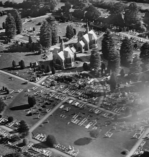
Another view of the chapels, again taken in 1928.
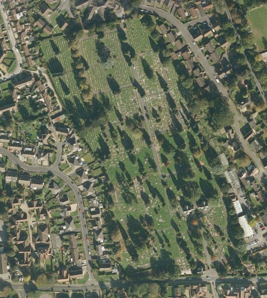
A modern aerial photograph of Yeovil Cemetery ('borrowed' from Google Maps). Preston Road runs along the bottom of the image with the main entrance visible at bottom right and the driveway leading to the twin chapels which are all in the lower right quadrant. The road in the lower left quadrant is Willow Road and that in the top right quadrant is Southway Drive, leading to Oakridge Park at centre right
Gallery
From my
collection
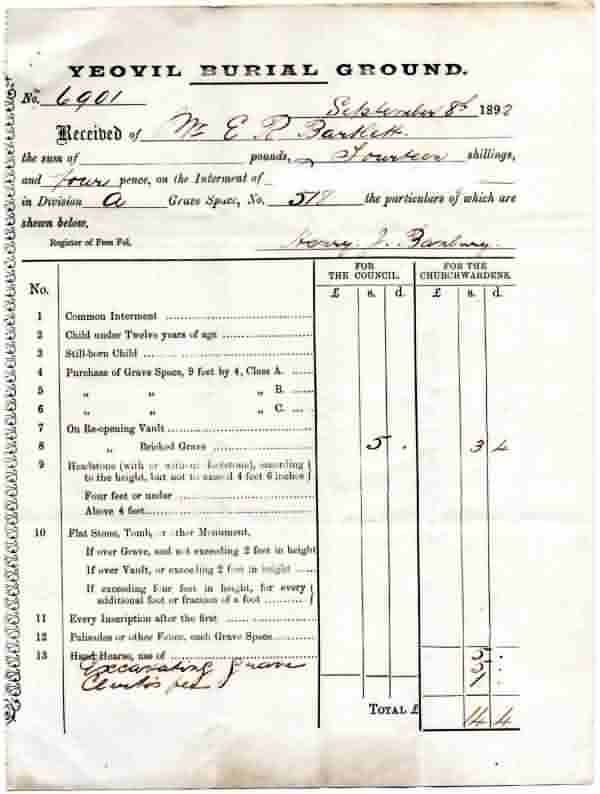
An interesting receipt, dated 8 September 1892, for an interment at 'Yeovil Burial Ground' (sorry about the poor quality). For re-opening a bricked grave, the Town Council received five shillings and the Churchwardens had three shillings and fourpence. The Churchwardens received an additional five shillings for the use of their 'Hand Hearse', five shillings for excavating the grave and one shilling for the Clerk's fee, I wonder how much the funeral directors charged?

This
colourised image
features in my
book 'Yeovil
- The Postcard
Collection'.
A photograph of the entrance to the cemetery, taken around 1900 from The Park.
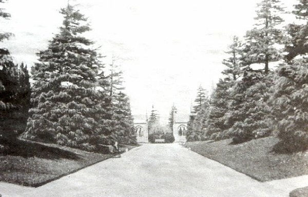
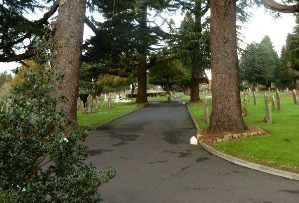
A postcard of around 1900 looking along the avenue towards the chapels from the main entrance.

This colourised photograph
features in my
book 'Yeovil
From Old
Photographs'.
An early photograph of the cemetery, including the chapels when they had spires.

Yeovil Cemetery Lodge and main entrance in a colourised photograph of the 1960s.
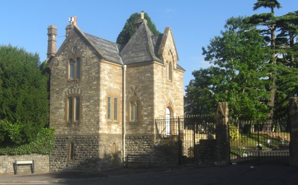
The Lodge House and main gates to the cemetery. The cemetery walls and gates facing Preston Road date to 1863. The Lodge was designed by Robert Shout. The walls are of boasted local stone, coursed, with worked copings and varying in height. The tall gabletted stone gate piers have twentieth century wrought iron gates and railings alongside. Photographed in 2013.
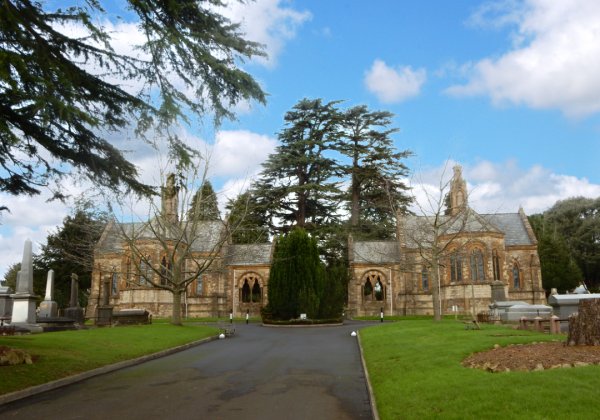
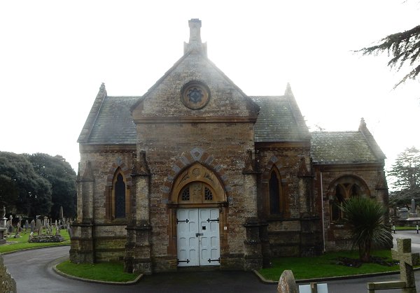
The twin mortuary chapels seen from the main entrance driveway. The eastern chapel (at right) was consecrated for the use of Church of England use while the western mortuary chapel (at left) remained unconsecrated for use by Non-Conformists. Photographed in 2016.
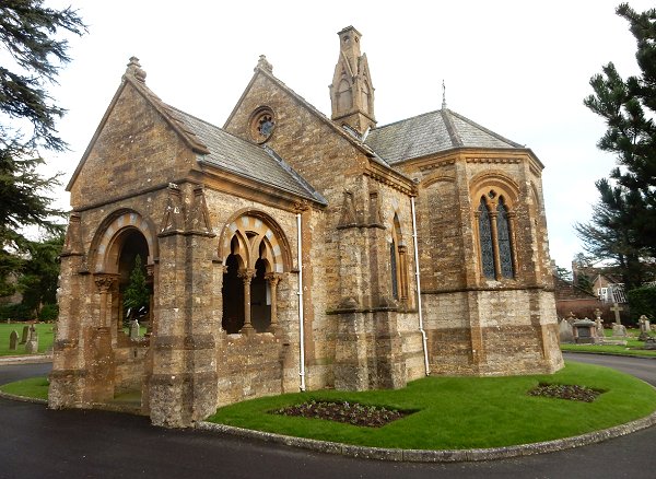
The eastern, Church of England chapel, seen from the southwest. Photographed in 2016.
.... and seen from the south. Photographed in 2016.
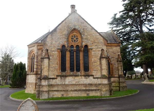
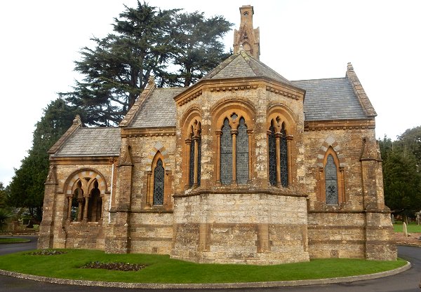
.... and from the east. Photographed in 2016.
.... finally, seen from the north. Photographed into the sun in 2016.
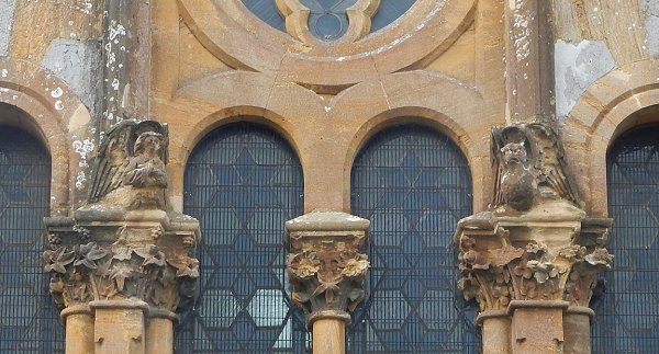
The fine carving on the capitals of the eastern window of the consecrated (Church of England) chapel; the symbols of St Matthew and St John (the angel and the eagle) with ivy and maple leaves underneath; the capital of the central shaft is carved with passionflower leaves. Photographed in 2016.
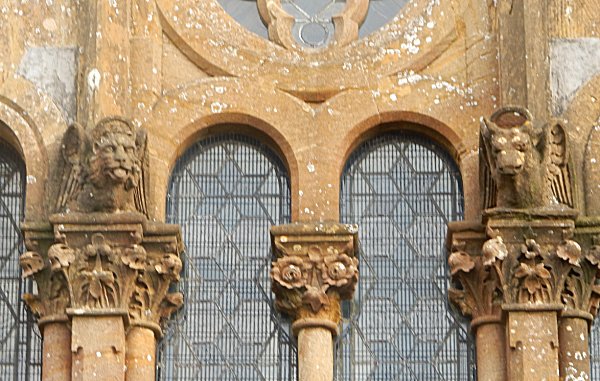
The carving on the capitals of the western window of the unconsecrated (Non-Conformist) chapel; the symbols of St Mark and St Luke (the lion and the bull) with foliage beneath. Photographed in 2016.
A view of the cemetery looking north from the mortuary chapels. Photographed in 2016.
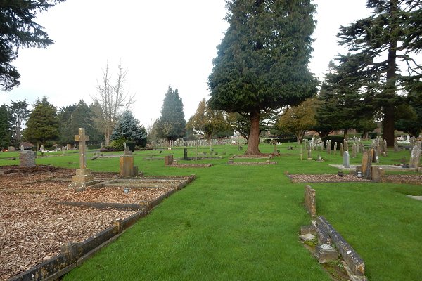
A general view of the cemetery looking north. Photographed in 2016.
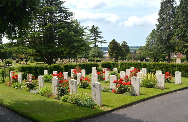
The area tended by Commonwealth War Graves Commission. This plot contains graves of military personnel killed during the Second World War. Military personnel killed in the Great War are scattered throughout Yeovil Cemetery but are usually (but not always) recogniseable by their CWGC headstones, identical in style to those shown here. Photographed in 2015.