Field's End
Field's End
The most northerly field in Preston Plucknett
Field's End was originally a large field along the north parish boundary of Preston Plucknett, lying to the immediate south of Thorne Lane and bounded by the parish boundary with Brympton in the west and Larkhill Lane in the east.
By the time of the 1763 survey of the Manor of Preston, the large field was subdivided and used as arable. The middle of the later three parcels called Field's End in 1846 (Parcels 64, 65 and 68) was divided into two fields called Four Acre Field's End and Three Acre Field's End which, by 1849 had been amalgamated to form Parcel 65. A further small field, also called Field's End (Parcel 63), lay to the south of Field's End (Parcel 64). This was bounded to the east by Eighteen Acres Sleight (Parcel 62), which also formed the southern boundary with Parcel 65, and to the south by Hurdle Corner (Parcel 61). Parcel 68 was bounded to the south by Cold Thorn (Parcel 67) and to the east by Hacker's Close (Parcel 69).
The 1846 Preston Tithe Map shows Field's End as the three Parcels mentioned above, but this was only the western half of the original large field, the eastern half being divided into Hacker's Close (Parcel 69), Gayley Mead (Parcel 71) and Lower Crossways (Parcel 72).
The Preston Plucknett Tithe Apportionment of 1848 noted that Field's End (Parcels 63, 64, 65) were owned by Lady Georgiana Fane of Brympton d'Evercy and the tenant was Thomas Hawkins (who was a tenant of over 200 acres in over 40 parcels in the parish). Parcels 63 and 64 were pasture, 65 was arable. Parcel 68 was owned by William Jones Prowse and the tenant was James Pope. A note in the Apportionment states that the field was "Abbey Lands".
During the Second World War the three fields abutting Thorne Lane were used by the Army (Houndstone Camp had been built to the immediate west of Field's End) and from the 1946 aerial photograph (see below) the fields were used to train troops how to dig trenches.
All parts of Field's End disappeared when the Abbey Manor estate was built in the 1980s and the site is now occupied by Dare Close, Roche Close, Merevale Way and Thorne Gardens.
maps & Aerial photograph
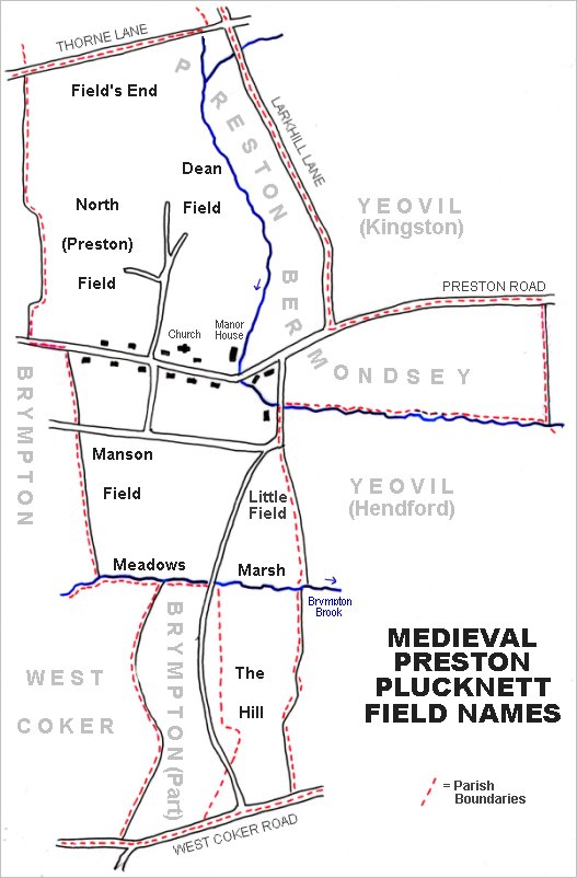
The main post-medieval fields of Preston Plucknett. The original large medieval field called Field's End is at top left.
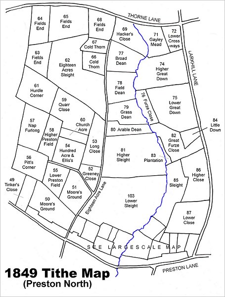
Map based on the 1849 Tithe Map showing the four fields (Parcels 63,64,65 and 68) at top left, that were remnants of the original large, open medieval field called Field's End.
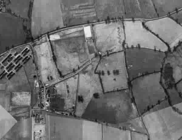
This is a 1946 aerial photograph showing huts of Houndstone army camp at centre left. The three fields to its right, clearly showing zig-zag trenches dug as training exercises, are Field's End.
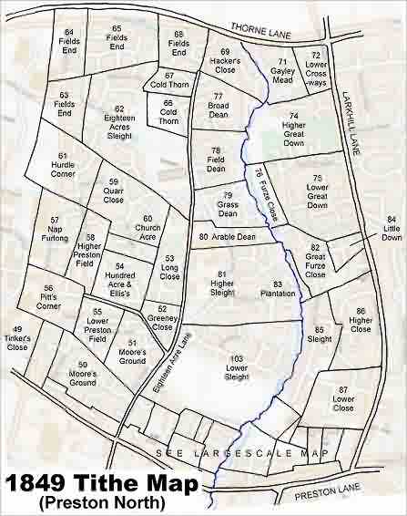
The 1849 Tithe Map superimposed over the modern Ordnance Survey map.