Hather Mead Hill / the down
HatherMead Hill / The Down
A hill within the great manorial East Field
The area occupied by the great medieval East Field of Kingston manor, in terms of today's geography, was (very roughly) bounded by St Michael's Avenue in the west, St John's Road in the north, the River Yeo in the east and Sherborne Road in the south. The 1589 Terrier indicates the three great medieval fields of Kingston Manor - west, middle and east - as shown on the map below.
Hather Mead, or Hathermead, was probably a large medieval sub-field running west-east across the centre of the East Field and included the long hill called Hather Mead Hill. The eastern end of the hill was known as 'The Down'.
The 1633 Survey of Kingston referred to it thus "4 acres of meadow lying in Dichelmore and Meade [Hathermead] under Downe [The Down / Hathermead Hill]".
In his will dated 13 October 1694, Yeovil mercer John Cary left "All those Six acres and halfe of pasture (be it more of less) lying at Hather Mead hill, six acres more of pasture ground lying at Lyde near Lydehouse".
Hather, probably a corruption of heather, was derived from Old English hæþ meaning 'untilled land' or, indeed, just 'heather', frequently a dominant plant of such land. Mead derives from the Old English mæd, meaning 'meadow or pasture'.
Hather Mead Hill is a large hill, lost today with its covering of urban sprawl. In the modern landscape, the summit lies immediately south of St John's Road, between Netherton Road and Hawthorn Road while it's highest eastern point is at the eastern end of Montrose Road and from here the land falls away north towards Lyde, east to the River Yeo and south, beyond Meadow Road toward Little Lyde. The crest of the hill tends to continue along Montrose Road and In medieval times this was the part of the hill known as 'The Down'.
In her will of 1754, spinster Anne Markes referred to "... my Orchard called Down ...".
Opposite the western end of Montrose Road, where it meets Meadow Road, are the very steep flight of steps running down the south face of the hill and at the junction of Meadow Road and Netherton Road is where the steep western descent of the hill runs along Netherton Road to join Monmouth Road.
By the time of the 1846 Tithe Apportionment the area had been sub-divided into a number of fields, shown on the map below and running more or less west to east, as follows :-
Higher Hather Mead (Parcel 956) - measured 2a 2r 21p and was recorded as meadow for growing hay. It was owned by Elizabeth Upton and leased to Thomas Lukins. In the early twentieth century it was used as allotments (see Gallery below) and only built on after the Second World War. Today it is occupied by the northern half of Sunningdale Road as far as Greenhill Road and including the whole of Lingfield Avenue.
Lower Hather Mead (Parcel 955) - was owned by Thomas Dampier and leased by Edward Wills Jnr. It was recorded as 3a 3r 20p and used as meadow. In June 1896 the field was sold, at which time Mr T Moore was tenant. Again, only built on after the Second World War, today it is occupied by houses on the west of Monmouth Road including the southern end of Welland Road and the northern houses at the east end of Charles Road.
Cox's Close (Parcel 928) - this was the western end of Hather Mead Hill, falling to the west, and its northeast corner was the highest point of the hill. The 1589 Terrier, in referring to the East Field recorded "In Newclose and Coxclose 54ac and 29ac of arable together upon the Down". The 1633 Survey of Kingston recorded "a close of land or pasture called Cox Close" and the 1743 Terrier referred to it as Coxes Close.
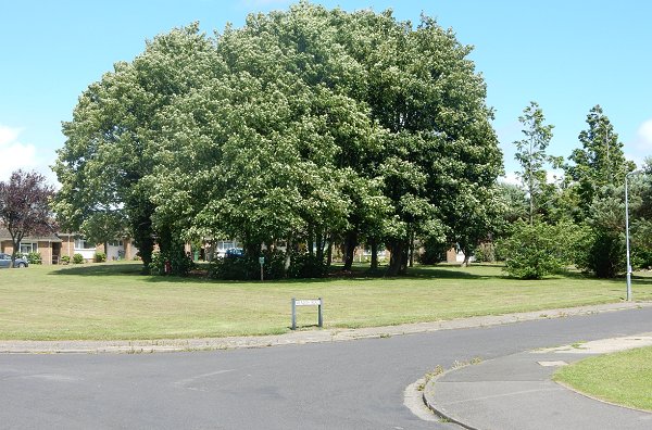
In his will of 1828 William Row stated ".... all that Close of Pasture Ground called Coxes Close or Collines [Delight ?] purchased of [word illegible] Gould containing about six acres....". In the 1846 Tithe Apportionment the owner was John Tanner Whiteley Pitcher ('natural' son of William Row) and the tenant was John Brook the Younger. Measuring 4a 0r 10p, it was used as pasture for grazing livestock. Cox's Close was bounded on the east by Fouracre Mead (Parcel 954) and to the north by Harbin's Ground (Parcel 930). Today it is covered with the houses and gardens of the northern part of Netherton Road although the southeastern corner, at the junction with Meadow Road, remains as a small green field with a stand of (planted) trees (see Gallery).
Hather Mead Hill (Parcel 959) - measuring 1a 0r 0p this was a thin strip of arable land between Cox's Close (Parcel 926) to the north and Great Hather Mead (Parcel 960) to the south. It was owned by A'Court Daniell and leased to William Jennings. In May 1848 the field was sold, still with Jennings as tenant. It was sold again in June 1896 at which time James Vickery was tenant. Built on during the late 1960s, today it is the steep western end of Netherton Road as it runs down the hill to join Monmouth Road at the bottom. (see Gallery).
Hather Mead Hill (Parcel 927) - again owned by A'Court Daniell and leased to William Jennings, this field at the eastern end of the hill itself. It measured 5a 0r 20p and was arable, used for growing crops. In May 1848 the field was sold, still with Jennings as tenant. It was sold again in June 1896 at which time James Vickery was tenant.
Great Hather Mead (Parcel 960) - this field was owned by William Jones Prowse, Lord of Kingston manor, and leased to Thomas Frost. It was recorded as 5a 0r 20p and used as meadow for growing hay since it lay alongside the stream (which is no longer visible above ground). An extension of the field in its southeast corner was known as Banger's Drang - FW Matthews in his "Glossary of the West Somerset Dialect" recorded that Drang, or Drong, was a narrow way between high hedges or walls or earth banks. Banger's Drang lead to Drang (Parcel 963). Great Hathermead and banger's Drang were sold in June 1896, at which time the tenant was James Vickery (see Gallery).
Only built on relatively recently, Great Hather Mead now contains houses along the south side of Netherton Road at its western end and the houses of Sedgemoor Close and Hathermead Gardens. The former Banger's Drang is now allotments and the footpath running alongside, at its eastern end it forms part of Sunningdale Doorstep Green (see Gallery).
Hather Mead (Parcel 961) - a meadow measuring 2a 2r 10p, this was also owned by A'Court Daniell and leased to William Jennings. In May 1848 the field was sold. Still remaining a field in 1946, it is now allotments (see Gallery).
Higher Sleight (Parcel 925) and Lower Sleight (Parcel 926) - these two fields formed the eastern end of The Down, and from here the ground fell away eastwards towards the River Yeo.
In his will of 1753, Yeovil butcher Thomas Francis wrote " I give devise and bequeath all that my Close called Slight within the Parish of Yeovil aforesaid unto my Son John Francis his Heirs and Assigns for ever Chargeable nevertheless with the Payment of the Sum of sixty Pounds to my said Son Thomas Francis within twelve Months after my decease."
Both parcels were owned by Sarah Rose and leased to Charles Marsh. It appears from the 1946 aerial photograph that the two fields had been merged by this time.
Parcel 925 was where The Down began to fall away to the north in the direction of Lyde Gurl valley. It measured 7a 0r 26p and was used as arable for growing crops. Today it is covered with the houses and gardens of the eastern end of Welbeck Road, the northern half of Lowther Road and houses on the southern side of the eastern end of St John's Road, all built in the late 1960s / early 1970s.
Parcel 926 was essentially the eastern crest of The Down but began to fall away in all directions except west. It measured 8a 3r 0p and was used as pasture for grazing livestock. Today the northern part contains the houses and gardens of Montrose Road, running along the actual crest of The Down, while the southern part falls away to the south and contains the houses and gardens of most of Meadow Road. The steepness of the hillside demonstrated by the photograph of the Meadow Road steps, in the southwestern corner of the former field, is seen in the Gallery.
For details on historic land measurement (ie acres, roods and perches) click here.
maps

This map, based on the descriptions in the 1589 Terrier and the 1846 Tithe Map of Yeovil shows the approximate boundaries of the Manors of Kingston and Hendford as well as the manorial three-field system used in Kingston.

A map of the great medieval East Field of Kingston Manor showing conjectured locations of several fields based on descriptions in the 1589 Terrier.
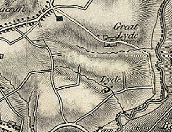
The 1811 Ordnance Survey map clearly showing topographical features, the most outstanding at centre is Hather Mead Hill running into The Down between Great Lyde and Lyde farms. At top right is Mudford Road at centre bottom is London Road (today's Sherborne Road). Snaking between the two is Brickyard Lane (today's St Michael's Avenue) and Meadway (today's Lyde Road), runs up to Lyde before the farm track continues to Great Lyde (no longer existing). The two streams shown on the map running into the River Yeo at right, are now piped underground.
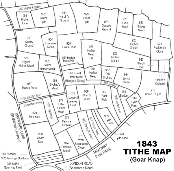
Drawn from the 1846 Tithe Map with field names added from the 1846 Tithe Apportionment, Hathermead, Hathermead Hill and The Down ran across the centre of the map.
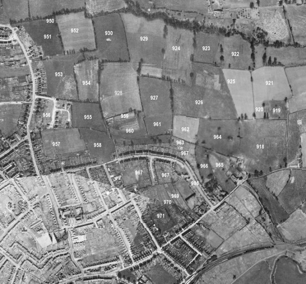
The 1946 aerial survey photograph (somewhat mis-aligned at bottom left) with parcel numbers of 1846 plotted on.
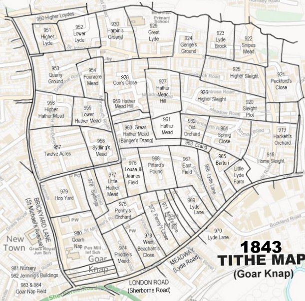
The 1843 Tithe Map overlaid onto a modern map of the area.
GALLERY
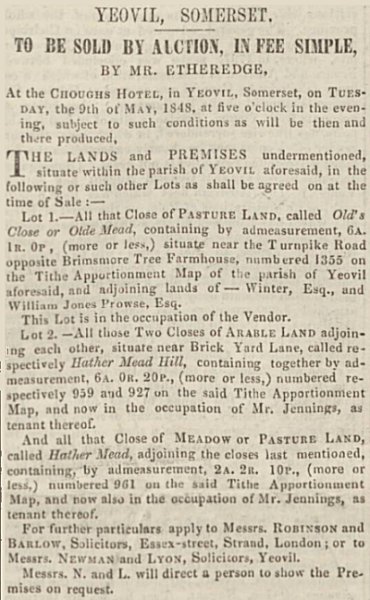
The notice of sale by A'Court Daniell of Hather Mead Hill (Parcel 959), Hather Mead Hill (Parcel 927) and Hather Mead (Parcel 961) as advertised in the 6 May 1848 edition of the Western Flying Post.
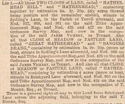
An extract of a sale of land featuring the second sale of the above parcels, plus 955, that was held in June 1896 and advertised in the Western Gazette.
From my
collection
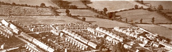
Taken from a 1930's postcard, and showing much of the area of the medieval Hather Mead, at bottom left are houses of St Michael's Avenue (formerly Brickyard Lane) with Rosebery Avenue (the former Sydling's Lane) running across to the centre. From centre bottom to bottom right are Glenville Road, Percy Road and Alexandra Road.
The hedgerow running from centre top to mid-centre right shows where Sydling's Lane turned north and later was the line of Monmouth Road, at the bottom of the valley with the western end of Hather Mead Hill in the top right quadrant.
The fields shown are as follows - At very top right is the southern end of Quarry Ground (Parcel 953) with the southern end of Fouracre Mead (Parcel 954) to its right. Below these are Higher Hather Mead (Parcel 956) being used as allotments and Lower Hather Mead (Parcel 955). Below these are Twelve Acres (Parcel 957) above the houses of Rosebery Avenue, with Sydling's Mead (Parcel 958) in the junction of what would become Rosebery Avenue and Monmouth Road. At top, right of centre, is Cox's Close (Parcel 926) and the hedgerow at its southern end marks where the narrow Hather Mead Hill (Parcel 959) was merged with Cox's Close. This is now the site of the steep western end of Netherton Road. In the very top right corner is the corner of Hather Mead Hill (Parcel 927) and below this is Great Hather Mead (Parcel 960) with the corner of Hather Mead (Parcel 961) just glimpsed at extreme centre right.
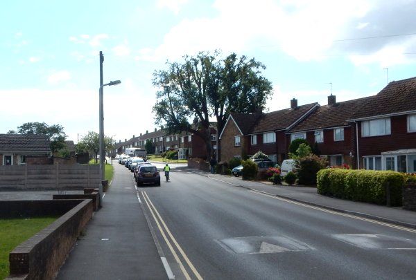
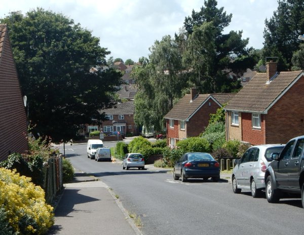
Photographed in 2016 from outside the Yellow Wagtail and looking west along St John's Road. The top of the hill (the houses to the right of the bus) was the highest point of Hather Mead Hill. The road and the bungalows to the left were built on Great Lyde (Parcel 929) and the houses to the right of the road were built in the spur of Genge's Ground (Parcel 924).
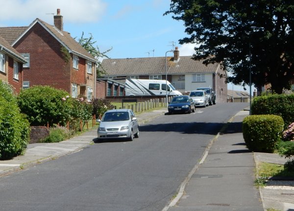
Looking east along the western end of Netherton Road. Originally Hather Mead Hill (Parcel 959), this is the steep western end of the hill. Photographed in 2016.
.... and looking west from the top of Netherton Road, down Hather Mead Hill to Monmouth Road. Photographed in 2016.
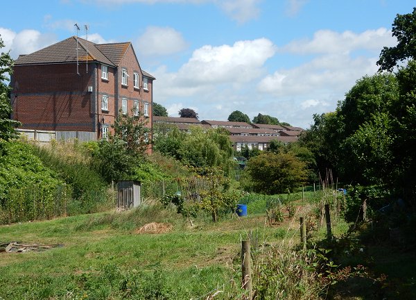
The western end of Banger's Drang, the extension of Great Hather Mead (Parcel 960), looking east. The block of flats in Hathermead Gardens at left was built in what had been the rising ground of the southeast corner of Great Hather Mead. In the distance at centre are the rooftops of houses in Woburn Road, Wentworth Road and Marlborough Road - all two storeys at the north and three at the south as they line the southern flank of Hather Mead Hill and The Down. Photographed in 2016.

The eastern end of Banger's Drang, now the Sunningdale Doorstep Green. At left would have been the former Drang (Parcel 963). Photographed in 2016.
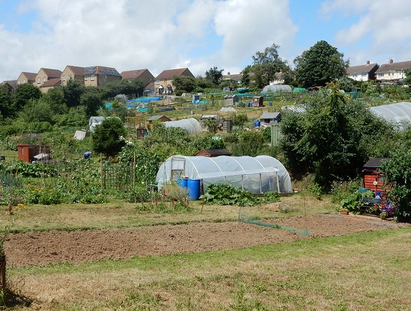
Hather Mead (Parcel 961) is now all allotments. At top left are the houses oh Hathermead Gardens built on the former Great Hather Mead (Parcel 960) and at top right houses of Meadow Road built on Hather Mead Hill (Parcel 927). Photographed in 2016.
The remaining green area on the corner of Netherton Road and Meadow Road. Formerly the southeastern corner of Cox's Close, this is the western end of Hather Mead Hill and to the immediate left of this photograph the ground falls sharply away down to Monmouth Road. Photographed in 2016.
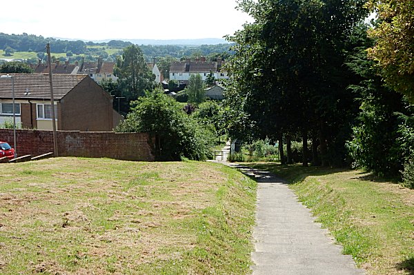
Taken from Meadow Road, in the southwest corner of the former Higher Sleight (Parcel 926) this photograph shows the steep descent of the southern side of The Down as the series of steps (all 64 of them) descend to the allotments now occupying Hather Mead (Parcel 961) hidden by the trees at right.
Montrose Road, looking west and taken from the very eastern end of the road (my front garden). This is the highest point of The Down, with the ground sloping down from here in all directions. Photographed on 6 January 2010.