Home Field
Home Field
A field within the Manor of Hendford
Home Field (Parcel 805) was originally a field within the Manor of Hendford and has been, for generations, part of Aldon Farm. As the name Home Field suggests, the field lay immediately next to the farmhouse. The name Aldon was known before Aldon house was built since Watt's map of 1806 shows a footpath "To Aldon Farm, etc."
By the time of the 1846 Tithe Apportionment, Home Field was owned by John Batten Snr and let to John Brook the Elder (from c1810 to 1846) followed by John Brook the Younger (from 1847 to 1854). It was recorded as arable for growing crops and measured 4a 0r 9p. For other tenant farmers, see Aldon Farm..
Home Field (Parcel 805) was bordered on the north by Plantation 3 (Parcel 807), to the east by Footpath Field (Parcel 806), to the south by Aldon farmhouse and its drive, and to the west by Gage Hill (Parcel 790).
Today, the former Home Field forms part of the parkland surrounding Aldon House.
For details on historic land measurement (ie acres, roods and perches) click here.
maps

This map, based on the descriptions in the 1589 Terrier and the 1846 Tithe Map of Yeovil shows the approximate boundaries of the Manors of Kingston and Hendford as well as the manorial three-field system used in Kingston.
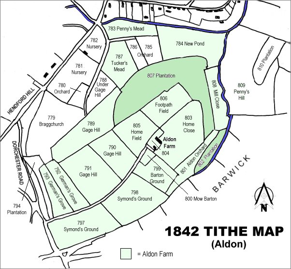
The 1842 Tithe Map showing the Aldon area and the parcels of Aldon Farm shaded light green. Home Field (Parcel 805) is left of centre.