In Hewish Field
In Hewish Field
Once part of the great medieval field called Northover
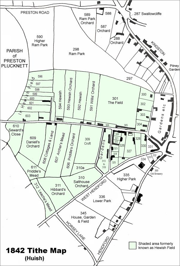
Hewish Field was once part of the great medieval field called Northover (see first map below). Northover itself was later broken up and part of it became a large common field called Hewish, or Hewish Field, stretching from Ram Park in the north, the boundary with the parish of Preston Plucknett in the west, today's West Hendford in the south and roughly as far as today's Clarence Street in the east. The parcels comprising the former great Hewish Field are shown shaded green in the 1842 Tithe Map below.
The name Huish, in its various spellings through time, derives from the Old English 'hiwisc' meaning a household.
On 1 July 1415 Thomas, Earl of Arundel, granted the advowson of Yeovil Rectory to Henry V with "two acres in the field called Huysh".
It was recorded that in 1611 St Leonard's Fair for rother cattle was held in "the field called Huishe in Hendford" - in this instance Hendford being the Manor of Hendford, not the road of that name. As a sidenote; the word 'rother' is an old Anglo-Saxon word for cattle. The rother cattle were long-horned, fleshy beasts prized for their meat, milk, hide and horn (see photo below).
An indenture of 1715 remarks on six acres of arable land "lying in a common field called Hewish in the tything of Hinford.... lately enclosed" - the words 'lately enclosed' being a good indication of when this common field began to be parcelled up.
By the 1750s the division parcels of Hewish Field were more or less finalised as shown in the 1842 Tithe Map below. The northeast corner (bounded by Higher Ram Park in the north, the Parish of Preston Plucknett to the east and Huish to the south) had been divided into several narrow strip parcels on an east-west axis and sold separately.
By the time of the 1846 Tithe Apportionment these strips were all referred to as 'In Hewish Field' and comprised Parcels 596 to 603. The parcels were reached by a field access track that is shown on Watt's map of 1806 and the track survives today (see Gallery).
During the Second World War, if not before, all the collective In Hewish Field parcels were being cultivated as allotments as seen in the 1946 aerial photograph below. Today all these parcels are covered with the houses and gardens of Carisbrooke Gardens and Huish Gardens.
Details of each parcel of In Hewish Field as shown in the Apportionment are as follows -
Parcel
595 -
In Huish Field.
Arable. 0a 1r
19p
Owned and
occupied by
George Hallett.
Parcel
596 -
In Huish Field.
Arable. 1a 0r
16p
Owned by fancy
goods dealer
Ince Gamis,
occupied by John
Hockey.
Parcel
597 -
In Huish Field.
Arable. 0a 2r
34p
Owned by
solicitor
James Tally
Vining and
occupied by
draper
James Curtis the
Elder.
Parcel
598 -
In Huish Field.
Arable. 0a 2r 5p
Owned by George
Hallett,
occupied by
William Cupper.
Parcel
599 -
In Huish Field.
Arable. 0a 2r
19p
Owned by Thomas
Ostler, occupied
by Emanuel
Pilton.
Parcel
600 -
Houses &
Gardens. 0a 1r
26p
Owned by
solicitor
Edwin Newman,
occupied by
Silas Griffen.
The houses are
extant and known
as
Huish Gardens,
Silas Griffen
most likely
acted as a house
agent for Newman
by letting the
houses,
collecting
rents, etc.
Parcel
601 -
In Huish Field.
Arable. 0a 1r
19p
Owned by
solicitor Edwin
Newman, occupied
by Silas
Griffen.
Parcel
602 -
In Huish Field.
Arable. 0a 2r
19p
Owned by Thomas
Ostler, occupied
by Emanuel
Pilton.
Parcel
603 -
Houses &
Gardens. 1a 1r
30p
Owned by
George
Harris, occupied
by James Boon -
again, Boon may
have simply been
the house agent
for Harris.
For details on historic land measurement (ie acres, roods and perches) click here.
maps

This map, based on the descriptions in the 1589 Terrier and the 1846 Tithe Map of Yeovil shows the approximate boundaries of the Manors of Kingston and Hendford as well as the manorial three-field system used in Kingston.
This map is based on the 1842 Tithe Map with field names added from the 1846 Tithe Award. The area shaded light green was originally a large common field called Hewish Field that had been formed out of the earlier medieval field called Northover. By the time of the 1842 Tithe Map, shown here, Hewish Field had been further sub-divided into many parcels as shown.
In Hewish Field is at centre left.
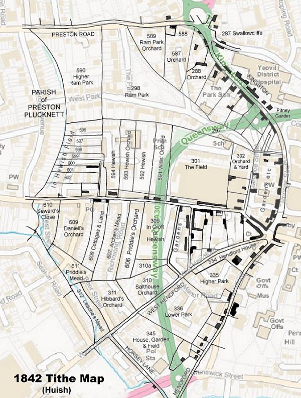
The 1842 Tithe Map superimposed (roughly) over a modern street map showing where several modern roads, for example the rear gardens of the eastern side of Grove Avenue, follow former field boundaries.
Gallery
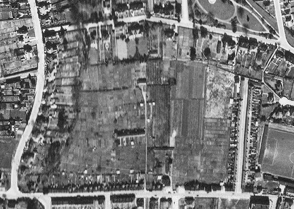
The 1946 aerial photograph clearly shows The Park and West Park running across the top of the photograph with part of Sidney Gardens seen at top right. Grove Avenue runs down the left side and Huish running along the bottom of the photograph. The eastern boundary of the collective In Hewish Field parcels was the stream running along the eastern end of the gardens on the east side of Grove Avenue, seen here as a wavy black line of bushes. The east boundary is the field access track seen at centre, running past Huish Gardens and continuing to what looks like a large house. It is clear from this photograph that all the parcels making up In Hewish Field were being used as allotments.
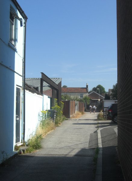
Huish Gardens lane seen from Huish with the end cottage of Huish Gardens, now Carisbrooke Gardens, at centre. This was the former field access track that existed in 1806. Photographed in 2013.