eastland road
eastland road
Formerly known as Ryall's Lane and then Kiddle's Lane
 Eastland
Road has been
around,
primarily
nothing more
than a field
access track in
the lower part
of Kingston
Manor's Middle
Field, for centuries
but has only
recently
acquired its
present name.
Between the
1760s and the
1790s wealthy
glove
manufacturer
John Ryall
had a
glove factory in
the area and the
lane was known
as Ryall's Lane
and is shown as
such on Watt's
map of 1806 seen
below.
Eastland
Road has been
around,
primarily
nothing more
than a field
access track in
the lower part
of Kingston
Manor's Middle
Field, for centuries
but has only
recently
acquired its
present name.
Between the
1760s and the
1790s wealthy
glove
manufacturer
John Ryall
had a
glove factory in
the area and the
lane was known
as Ryall's Lane
and is shown as
such on Watt's
map of 1806 seen
below.
By the time of the 1841 census the lane was known as Kiddle's Lane after glove manufacturers John and William Kiddle who were active in the 1840s and 1850s. Even so, at this time the track still didn't extend beyond the point where today's Eastland Road crosses Gordon Road.
The first houses built in Kiddles Lane were a couple of cottages close to William Bide's leather factory on the corner of Reckleford, and a larger residence roughly where the modern Kiddles development is today. Both cottages and residence appear on maps between 1831 and 1858 but by 1886 the two cottages had become a short terrace of five.
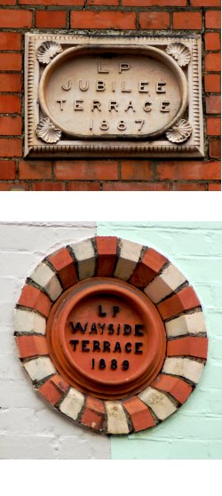
Both the single residence and the terrace were still standing in the early 20th century but the terrace had been demolished by 1927 and the single residence by the 1940s. The earliest houses surviving today are Clifton Terrace, built in 1870. These were followed by Jubilee Terrace built in 1887, the year of Queen Victoria's Golden Jubilee, followed in 1889 by Wayside Terrace - both built by local builder Lyndall Pomeroy.
The name Kiddle's Lane survived well into the twentieth century and Eastland Road became used around 1920. Today the name Kiddles has been used for a modern housing development built almost on the site of Ryall's Leather Dressing Yard, later Kiddle's Dressing Yard, off Eastland Road.
maps
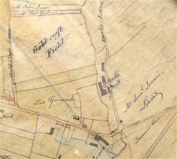
E Watts' map of Yeovil of 1806 shows the location of John Ryall's glove factory and dressing yard in what was known at the time as Ryall's Lane.
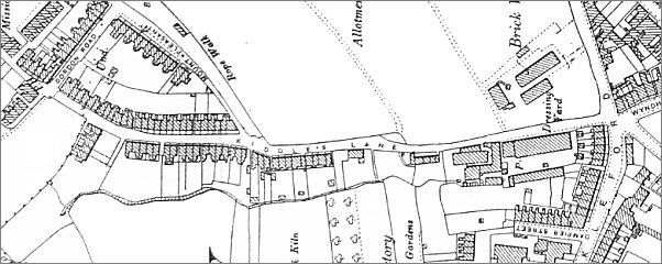
Map based on the 1903 Ordnance Survey (turned through 90° with north at left) showing Kiddle's Lane running from Reckleford at right as far as the newly-built Gordon Road at left.
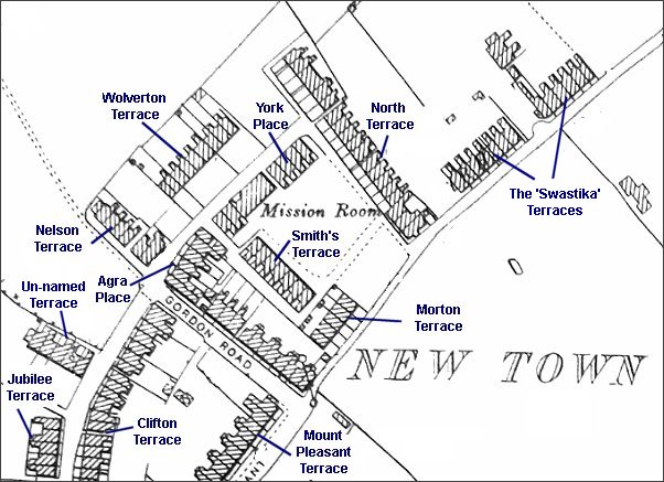
Map based on the 1901 Ordnance Survey showing the different speculative housing projects built in the early days of New Town.
Most of these
developments
have their own
page -
Agra Place,
Clifton Terrace,
Jubilee Terrace,
Mount Pleasant
Terrace,
North Terrace,
Smith's Terrace,
Swastika
Terraces,
Wolverton
Terrace,
York Place,
gallery
From my
collection. This
photograph
features in my
book 'Yeovil From Old Photographs'.
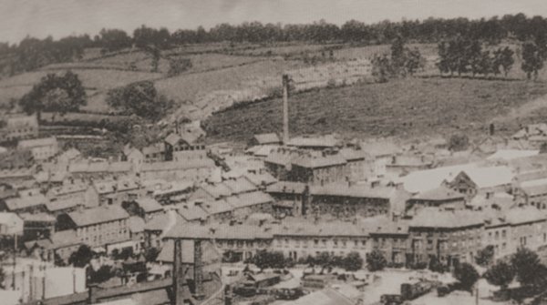
In the top half of the photo, Kiddles Lane (today's Eastland Road) runs left of the chimney with fields either side!!! Behind the chimney is Mount Pleasant and the dark hedgerow in front of the houses marks the site of the rope walk that extended to the trees at right.
This photograph dates to about 1900 and shows, at centre, the chimney of the Eastland Road brickworks with its associated buildings clustered around its base. To its left is the leather works built by William Bide (recogniseable by the double roof with a row of six black windows). Running along the bottom of the photograph is Station Road with the Alexandra Hotel at bottom right.

From the Cave
Collection
(colourised),
Courtesy of South Somerset Heritage Collection
Reckleford at the junction with Eastland Road. Within the decade the house at the left was demolished for the widening of Reckleford to dual carriageway standard. Reckleford School, seen at the right, remains today. Photographed in the 1960s.
Courtesy of Mark
Rowe
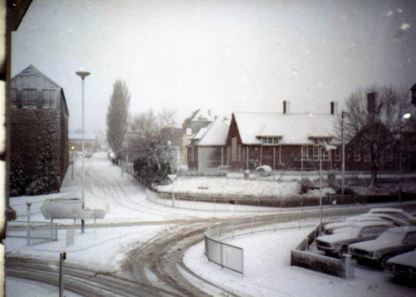
The junction of Eastland Road, Reckleford and Wyndham Street during winter 1982.

The southern end of Eastland Road as it joins Reckleford. The mess at right, unattended protection for pedestrians from falling bits of masonry from Bide's leather works, at right, has been forcing pedestrians into the road for years now. About time someone decided what to do with this area, perhaps? Photographed in August 2024.

Courtesy of
Chris Rendell
Looking back to South Street from Eastland Road in a colourised photograph of the 1980s.
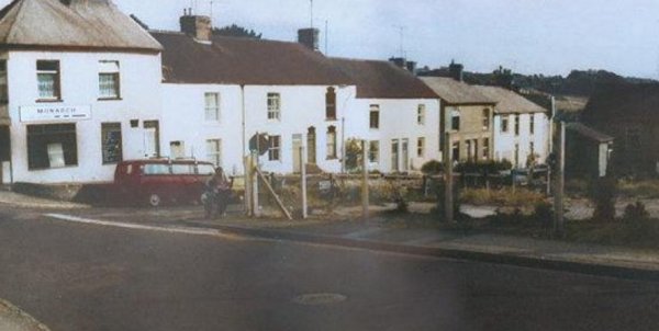
The 'top' of Eastland Road, seen from Highfield Road in a colourised photograph of the 1970s. The Monarch Laundry , on the corner , is seen at the extreme left of the photograph.
Courtesy of
Chris Rendell
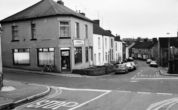
Eastland Road seen from the Nelson Inn with the Monarch Laundry (still there) on the opposite corner. Photographed in 1985.
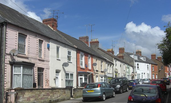
The early housing of Kiddle's Lane, now Eastland Road, including Wayside Terrace right of centre. Photographed in 2013.