shen's higher ryalls
Shen's higher ryalls
A field in the great Middle Field
Originally part of the great medieval Middle Field of Kingston Manor, E Watts' map of 1831 shows Shen's Lower Ryalls as a large field situated between Ryall's Lane (today's Eastland Road) and Lower Reckleford. It is also shown on the 1846 map by E Watts Jnr. Shen is simply a dialect pronunciation of Shean - a former owner of the land.
By the time of the 1842 Tithe Map, Shen's Lower Ryalls had been split into two fields; Shen's Higher Ryalls (Parcel 993) and Shen's Lower Ryalls (Parcels 530 and 531). The 1846 Tithe Award notes both parcels as arable land (that is, for growing crops). Shen's Higher Ryalls was measured as 4a 0r 10p.
Both Shen's Higher Ryalls and Shen's Lower Ryalls had been in the ownership of the Isaac family of the farmhouse that was later to become the Glovers Arms in Reckleford. At the time of the 1846 Tithe Apportionment both parcels were owned by yeoman Samuel Isaac and occupied by Henry Bryant Phelps. Samuel Isaac died in 1849 and the fields passed to his brother Thomas who sold them off within six months.
Both Shen's Higher Ryalls and Shen's Lower Ryalls changed hands again in March 1850 between the Venerable and Reverend William Thomas Parr Brymer, glove manufacturer Henry Bryant Phelps and solicitor and financier Thomas Lyon.
In an indenture dated 10 April 1912, both Shen's Higher Ryalls and Shen's Lower Ryalls were sold to the Yeovil Corporation.
Shen's Higher Ryalls stretched from today's Eastland Road to Gordon Road. It was bounded on the west by Ryall's Lane (later Kiddle's Lane and today's Eastland Road), on the north by Drang (Parcel 994 and site of the later rope walk running alongside Mount Pleasant), to the east by Marsh Furlong (992) and to the south by Shen's Lower Ryalls (530 & 531).
From the photograph dated to c1900 below, it will be seen that by this time the fields had been turned back into one large field again. By 1912 both fields were being used as allotments as shown by the map below.
Shen's Higher Ryalls, together with Shen's Lower Ryalls, was purchased by the Corporation in April 1912 from the joint owners, Henry Herbert Worsfold Mayo of North Coker and Frank Whitmash Mayo of Swallowcliffe House. The price for the land was £3,500 and at this time the land was described as 'Brickfields and Allotments'.
Today Shen's Higher Ryalls is built over by the whole of Westville and the northern section of Southville.
maps

This map, based on the descriptions in the 1589 Terrier and the 1846 Tithe Map of Yeovil shows the approximate boundaries of the Manors of Kingston and Hendford as well as the manorial three-field system used in Kingston.
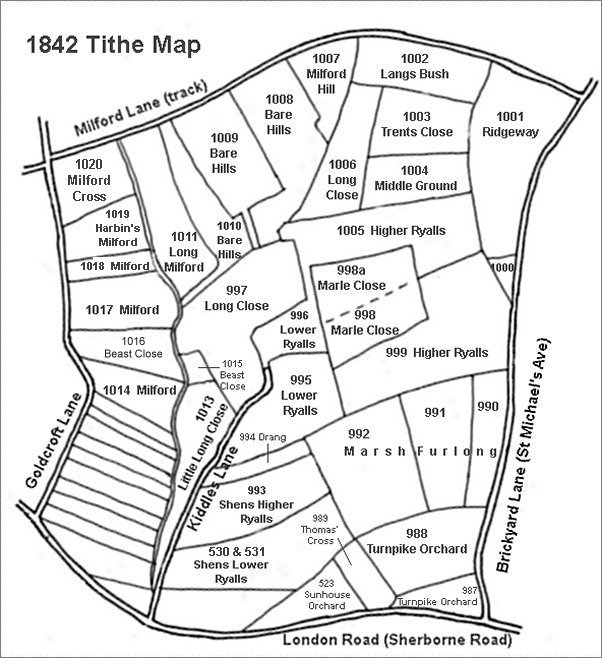
This map is based on the 1842 Tithe Map with field names added from the 1846 Tithe Award.
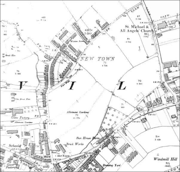
The 1912 Ordnance Survey showing the fledgling New Town surrounded by fields.
Courtesy of
Lawrence Doye
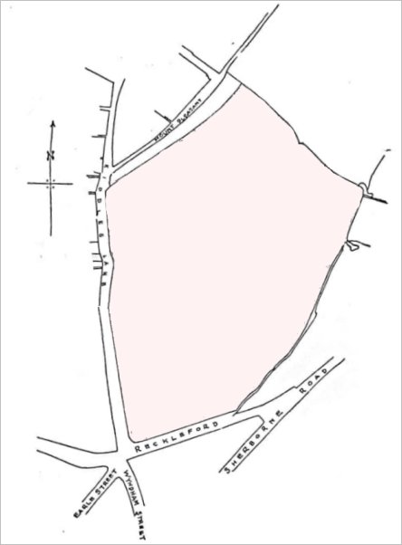
The map that formed part of the 1912 indenture for the sale of Shen's Lower Ryalls and Shen's Higher Ryalls.
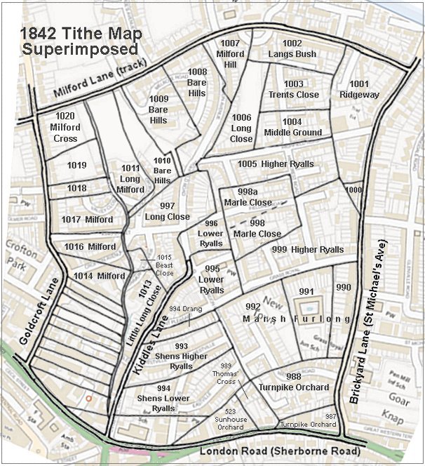
The 1842 Tithe Map superimposed (roughly) over a modern street map showing where several modern roads, for example Gordon Road, Grass Royal and Highfield Road, follow former field boundaries.
gallery
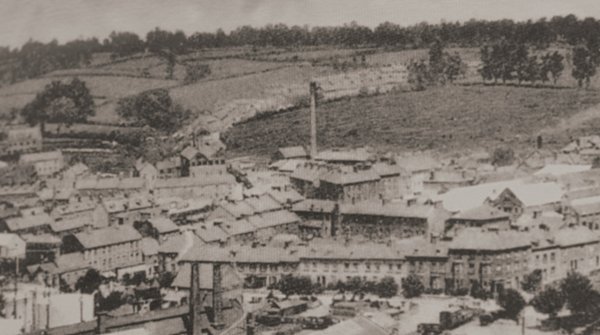
It wasn't all that long ago that there were more fields than houses in Yeovil. The large field occupying most of the top right is Shen's Ryalls - formerly Shen's Higher Ryalls (towards the top and the run of trees at top right) and Shen's Lower Ryalls (closer to the factory chimney).
This photograph dates to about 1900 and shows, at centre, the chimney of the Eastland Road brickworks with its associated buildings clustered around its base. To its left is the leather works built by William Bide (recogniseable by the double roof with a row of six black windows). Running along the bottom of the photograph is Station Road with the Alexandra Hotel at bottom right. In the top half of the photo, Eastland Road runs behind the chimney with fields either side!!!