Yeovil Turnpike commission
Yeovil Turnpike commission
Early road maintenance
Under the parish
Way Wardens the
local roads had
been
indifferently
repaired and
maintained such
that travel
beyond the town
was infrequently
undertaken by
most people.
This, of course,
restricted the
trading ability
of the town to a
great degree.
In 1753,
Turnpike
Commissioners
were appointed
for "repairing
and widening the
roads" of Yeovil
and by 1797
Billingsley was
able to report
“Few countries
can boast better
turnpike-roads
than may be
found in this
district....
they are,
comparatively
speaking, as
smooth as a
gravel-walk.
This may, in a
great measure,
be attributed to
the great
attention paid
to the breaking
of the stones,
which is done by
men with small
sledges in a
sitting posture;
and the stones
are reduced to
the size of a
pigeon's egg, at
an expense of
six-pence per
ton weight.”
The
Commissioners
held their first
meeting at the
Angel Inn on
Tuesday 12 June
1753, when the
following were
sworn in -
Edward Phelips
of Montacute
House, James
Hooper of
Hendford Manor,
W Tucker, T
Phelipps,
John Newman
of Barwick
House, Philip
Rawlings,
Edward Boucher,
John Daniell,
John Newman Jnr,
Swayne Harbin,
Jean Michell
Ceeves,
Samuel Daniell,
Robert Glisson,
Robert Goodden,
E Forbes, George
Bullock, William
Langdon and
Francis Fane of
Brympton
d'Evercy.
The Turnpike
Commissioners
ordered that
"three capital
gates be
erected" at
Hendford Bridge,
by today's
Railway Tavern,
Goar Knap
(on the "town
side" of
Sherborne Road near
the junction
with
Brickyard Lane
- today's
St Michael's
Avenue)
and "the
Head of
Kingston" at
Fiveways.
Collectors at
each of these
gates received a
salary of six
shillings per
week or "eight
shillings until
the toll houses
are completed".
Richard Slade
was elected
collector of the
tolls at
Kingston Gate,
William Chead at
Hendford and
Thomas Swetman
at Goar Knap.
There was also a
"stop gate near
the entrance
leading from Pen
Stile to Newton”
with John
Gregory being
appointed
collector there
at a salary of
2s 6d a week.
There were
eventually other
gates at
Watercombe Lane,
Combe Street
Lane, Goldcroft
and Dorchester
Road.
In its edition
of 12 November
1764 the
Caledonian
Mercury reported
"Last week a
horse in a cart,
near Yeovil,
taking fright,
leapt over one
of the turnpike
gates (which is
near five feet
high) and pulled
the cart quite
over, without
receiving any
damage."
In 1825 the
Turnpike Trust
made
improvements to
the London road
by diverting it
up Babylon Hill
and at the same
time Hendford
Hill’s gradient
was lessened by
the creation of
a cutting below
the Quicksilver
Mail. At
Cemetery Hill on
Preston Road the
road was widened
and lowered at
the same time.
In 1852 in his
Report to the
General Board of
Health
concerning,
among other
items, the
condition of
Yeovil's roads,
Thomas Rammell
wrote “The
Turnpike roads
of the parish
are under the
management of
trustees called
the Yeovil
Turnpike Trust,
and are repaired
by their own
Surveyor. About
£60 annually
(around £8,500
at today's
value) are
expended on the
bye-roads of the
parish without
the town. Toll
gates are
situate at all
points round the
town, but not so
as to interfere
in any way with
its traffic.” At
this time the
toll paid for a
horse not
drawing was 1½d
and drawing,
that is, pulling
a cart or
suchlike, was
4½d (58p and
£1.73 in today's
value).
One turnpike
highway ran from
Hendford to
Cuthedge (on the
Crewkerne road
by the Camp Road
turning to
Odcombe) with a
toll gate at
Hendford Bridge
(next to the
Railway Tavern)
and a toll-bar
at the junction
with the
Dorchester Road.
In the 1871
census the
Dorchester Road
turnpike gate
was operated by
Scots-born
Robert Noble, a
sergeant Chelsea
pensioner, who
lived there with
his wife Fannie.
Rammell, writing
in 1852,
commented "The
trustees lately
removed the
Hendford Gate
from the bridge
to the top of
the hill, a
distance of a
quarter of a
mile, in
accordance with
a wish expressed
by the
townspeople."
The Goar Knap
gate was moved a
few hundred
yards east to
Yeovil Bridge
and the
tollhouse, which
remains to this
day, was built
in 1856.
The Kingston
toll house was
rebuilt about a
hundred yards
from its
original
position when
the Yeovil
Turnpike Trust
was abolished in
1875 and at the
same time all of
Yeovil’s toll
gates, stop
gates and side
gates were
removed. The
Kingston toll
house was
finally
demolished in
1969 when
Kingston was
widened.
The Penstile
toll house, with
its stop gate,
had originally
been sited at
the junction of
Pen Style and
Newton Road
(hence its name)
but in the
latter part of
the 19th century
it was re-built
in its present
position on the
corner of Newton
Road and South
Western Terrace.
It is now named
Newton Lodge.
The toll house
on Mudford Road,
at the junction
with St Michaels
Avenue, again
dates to the
mid-19th
century. It is
now named
Turnpike
Cottage.
Map
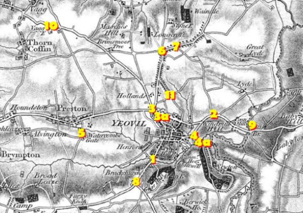
Extract of Christopher Greenwood's 1822 map of Yeovil.
KEY
1
Hendford Bridge
Stop Gate (aka
Hendford Gate)
2
Goar Knap Stop
Gate
3
Head of Kingston
Toll House and
Gate
3a
Re-sited
Kingston Toll
House
(post-Turnpike)
4
Pen Style Stop
Gate
4a
Pen Style
Turnpike House
5
Watercombe Side
Gate
6
Combe Street
Lane "Hutt Gate"
7
Mudford Road
Turnpike House
8
Hendford Gate
9
Yeovil Bridge
Turnpike House
10
Jernegan's
Hut Side Gate
11
Milford Lane
Side Gate
(part of today's
Goldcroft)
sCHEDULE OF tENDERS
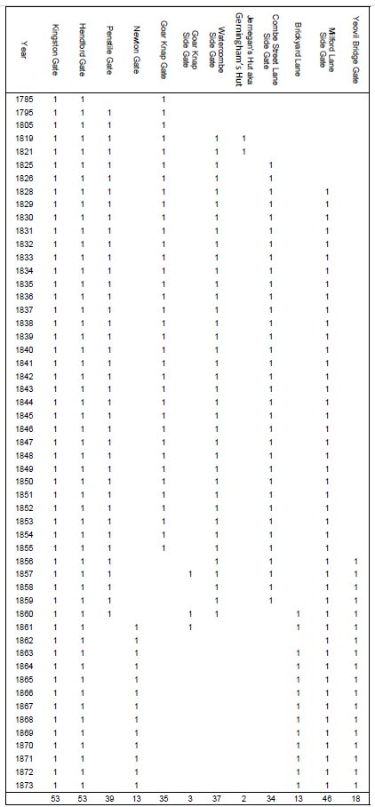
This table represents the gates where the annual tolls were sold. The data comes from various newspapers, especially the Western Flying Post or Sherborne Mercury and, latterly, the Western Gazette. Until 1825 it appears that invitations to tender were not published in the newspapers with any regularity.
Note 1: Hendford Gate was at the bottom of Hendford Hill until 1837-38, when it was moved to the top of Hendford Hill and a new toll house was built. At the same time a new toll house was built for the Kingston Gate.
Note 2: Penstile Gate was at the junction of Middle Street and Newton Road until it was moved to the corner of Newton Road and South Western Terrace in 1860, after which it was known as Newton Gate.
Note 3: Goar Knap is mentioned as a side gate three times after the Goar Knap Gate was moved to Yeovil Bridge in 1856. This is presumed to be a mistake?
Note 4: The Combe Street Lane Side gate was moved to Brickyard Lane (today’s St Michael’s Avenue) in 1860.
Note 5: Milford Lane is the northern part of today’s Goldcroft.
gallery
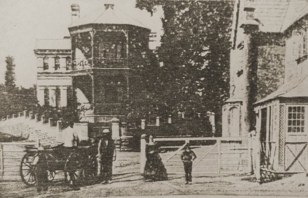
Photographed by Thomas Clarke between May and December 1874 from Kingston, and showing the new Fiveways Hospital and the Kingston Toll Gates. This is probably the earliest photograph of the new hospital that had opened just two years earlier, in January 1872.
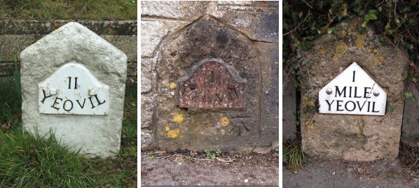
These are mile markers erected by the Yeovil Turnpike Commissioners, probably in the 1850's. At left is a two-mile marker located by the White Post garage on the West Coker Road, at the Camp Road turning. The metal plate design is known officially as the "Yeovil roll top plate". The central photograph, a one-mile "Yeovil roll top plate" marker, is located in a garden wall on the West Coker Road, between Danielsfield Road and Hillgrove Avenue. The broad Arrowhead carved in the stone below the plate is an Ordnance Survey benchmark used in surveying. The third mile marker is located in a garden wall on the Ilchester Road, nearly opposite the old Picketty Witch. The style of this marker plate is officially known as the "Yeovil gable plate".
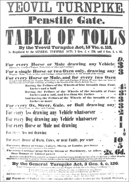
A poster of 1852 displaying the charges for access through the Penstile Gate.