Peter street
Peter street
Built by, and named after, Peter Daniell
 The
draper and
mercer
Peter Daniell
of
Penn
House
owned a mansion
in
Middle Street
that had been
built by his
father. This
mansion stood
where the rear
of the WH Smith
building
bordering
Wine Street
stands today. He
also owned a
tract of land
between Middle
Street and
South Street
and much of the
land on the east
side of Grope
Lane, today's
Wine Street.
Until
the
1830s, Grope
Lane was the
only direct
access
wide enough to
allow a
cart to travel
from
High Street,
the
Borough and
Middle Street to
South Street.
The
draper and
mercer
Peter Daniell
of
Penn
House
owned a mansion
in
Middle Street
that had been
built by his
father. This
mansion stood
where the rear
of the WH Smith
building
bordering
Wine Street
stands today. He
also owned a
tract of land
between Middle
Street and
South Street
and much of the
land on the east
side of Grope
Lane, today's
Wine Street.
Until
the
1830s, Grope
Lane was the
only direct
access
wide enough to
allow a
cart to travel
from
High Street,
the
Borough and
Middle Street to
South Street.
Peter Daniell built Bond Street to connect Middle Street with South Street, possibly as early as 1824 when, in its edition of 11 October, the Western Flying Post reported that a workman "was buried by a fall of masonry in New Street, Yeovil".
In the late 1830s, Peter Daniell planned and built an extension to Grope Lane which became Union Street. The entrance to Union Street from Middle Street was originally very much narrower than today's road width. The lower part of Grope Lane, called Wine Street from the 1840's, remained named as such until at least the late 1870’s before becoming known as the southern half of Union Street.
Finally, Peter Daniell constructed Peter Street, named after himself, to join Bond Street with Grope Lane / Union Street. The initials 'PL PD' and the date 1836 were formerly on one of the original houses in the street and the Town Commissioners' Minutes of 1835 refer to the "new street called Peter Street". However, an indenture dated 7 November 1836, now in the Taunton Heritage Centre, refers to "Saint Peter's Street, leading from Wine Street to Bond Street" although other documents of the time referred only to Peter Street, so this is probably a mistake.
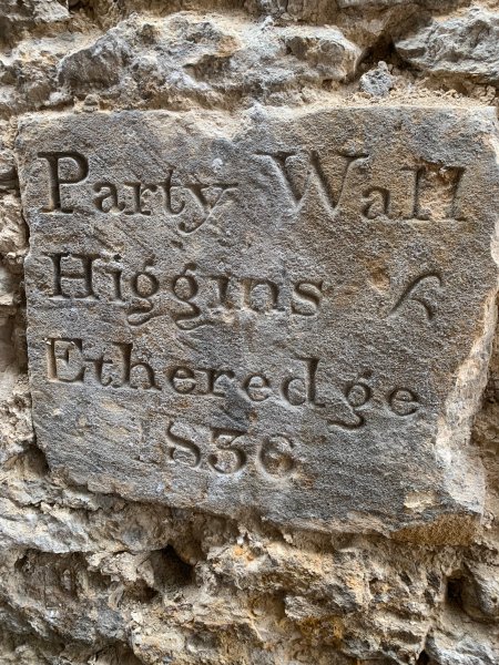
In September 2023, during restoration works to Trinity House, a plaque was discovered (see Gallery) dated 1836 - presumably indicating Trinity House to be possibly the first house to be built in Peter Street. The plaque records the "Party Wall" between a Mr Higgins and a Mr Etheredge. Neither Higgins nor Etheredge are recorded as living in Peter Street. I could find no record at all concerning Mr Higgins, but Mr Etheredge was presumably Henry Etheredge - an accountant, insurance agent, auctioneer and town surveyor who lived just around the corner in Wine Street.
In 1836 an additional street lamp was ordered to be placed "in the new Street called Peter Street" by the ‘Commissioners for improving the Town of Yeovil’.
The 1842 Tithe Map and the 1846 Tithe Apportionment show that the terrace of houses on the northern side of Peter Street had been built by this time. These houses were owned by wealthy glove manufacturer Thomas Dampier (after whom Dampier Street is named) and the tenant was the equally-affluent glove manufacturer William Bide Jnr (later Mayor of Yeovil), who almost certainly sub-let the houses to his workers. The two three-storey buildings that survive on the northeast corner of Peter Street and Union Street were built around 1880 (they don’t appear on maps until after 1900, but are shown on a photograph of 1881).
Trinity House, on the south side of Peter Street, was also built by this time but was the only building on the south side of Peter Street, the remainder being gardens. Trinity House - a nice example of domestic Regency architecture - is one of the few remaining original buildings in Peter Street. It was built in the Regency style and displays 'marginal lights' in the first-floor windows - a typically Regency feature. During the 1860s Trinity House was Mrs Wilson's Boarding and Day School.
In the 1840s there was a building on the southeast corner of Union Street and Peter Street although this would have fronted onto Union Street. This building was replaced by a much larger building, Clarendon House, during the 1850s. This new building, with a crenellated parapet (see Gallery), projected into Union Street, significantly reducing the width of the road. Its garden ran along Peter Street and, with outbuildings, stretched as far as Trinity House. It was the home of ironmonger and Mayor of Yeovil Henry Stiby who, together with his mother, lived there for over twenty years before moving to The Park. Clarendon House was then occupied by bookseller and stationer Frederick Whitby, son of Ebenezer Whitby of Princes Street.
By 1927 Clarendon House had been demolished and the site cleared. The site remained clear until after the Second World War when the present run of buildings from Union Street to Trinity House was built.
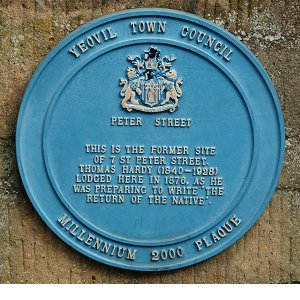
The Peter Street Millennium Plaque (shown above) is set, somewhat ignominiously, very low down on a dwarf wall by the car park exit and commemorates Thomas Hardy who stayed in 7 Peter Street between March and May 1876 as he was preparing to write 'The Return of the Native'. The northern terrace was demolished in the 1970's and the site is now a car park.
At the eastern
end of Peter
Street, on the
south side and
next to Trinity
House, is the
Church of the
Holy Trinity
erected by
Benjamin Ferrey,
the diocesan
architect, in
1846.
Congregations
declined and in
the 1980s plans
were set in
place to
relocate the
church to
Lysander Road.
The new church
was completed in
1998. The
original church,
once declared
redundant, was
converted by
Knightstone
Housing
Association to
Yeovil Trinity
Foyer in 1996 to
provide
accommodation
and training to
young people
aged between 16
and 24 years
old. This
facility has
recently closed.
MAPs
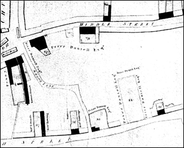
Map of 1813 drawn to show the properties owned by the Corporation (shaded black on the map) but clearly shows Grope Lane connecting the Borough with South Street and also shows the extensive lands owned by Peter Daniell.
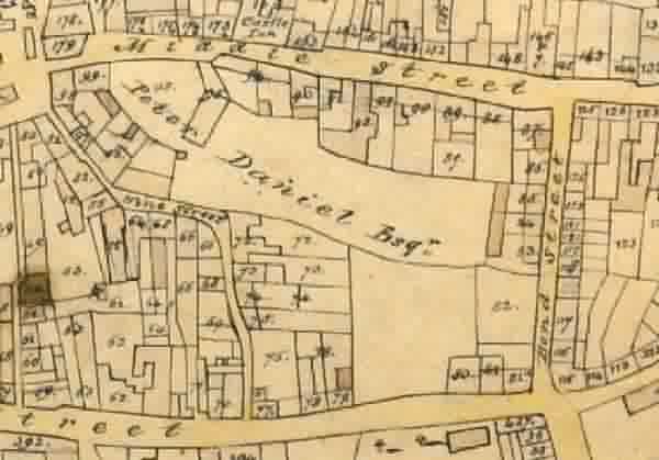
Edward Bullock Watts' map of 1831 showing the newly-built Bond Street. This was before Daniell 'improved' Wine Street by creating Union Street, and then connecting Bond Street and Union Street with Peter Street.
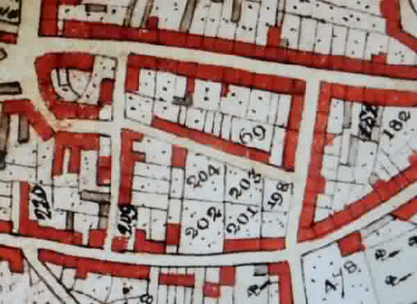
The 1842 Tithe Map, also by Edward Bullock Watts who was the Town Surveyor. During the intervening years between this map and the previous map, Union Street and Peter Street had been constructed and houses built.
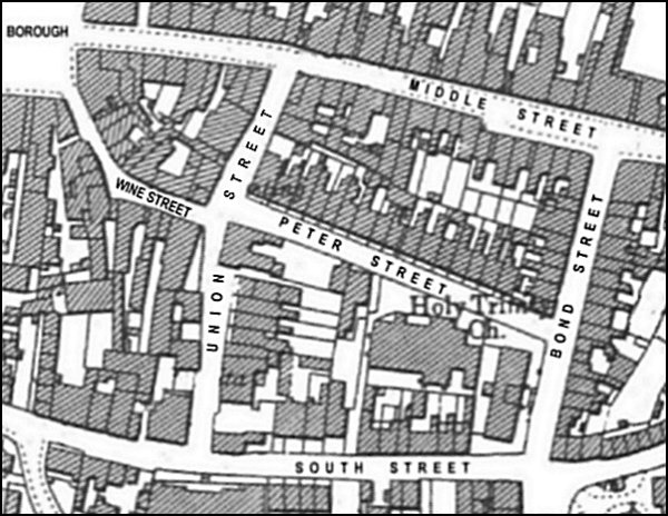
Map based on the 1901 Ordnance Survey. Originally Wine Street ran all the way to South Street as Union Street only came into existence in the 1830's and it wasn't until the 1870's that the southern half of Wine Street was renamed Union Street.
Note the large house on the southwest corner of Peter Street projecting into Union Street and reducing the width of the road by half. This was Clarendon House - the crenellated building seen in the first photograph below.
gallery
Courtesy of
David Chapman
In September 2023, during restoration works to Trinity House, this plaque was discovered dated 1836 - presumably indicating Trinity House to be possibly the first house to be built in Peter Street. The plaque records the "Party Wall" between a Mr Higgins and a Mr Etheredge. Neither Higgins nor Etheredge are recorded as living in Peter Street. I could find no record at all concerning Mr Higgins, but Mr Etheredge was presumably Henry Etheredge - an accountant, insurance agent, auctioneer and town surveyor who lived just around the corner in Wine Street. It is therefore assumed that Messrs Higgins and Etheredge were adjoining property owners, rather than residents and neighbours.
Courtesy of Rob
Baker
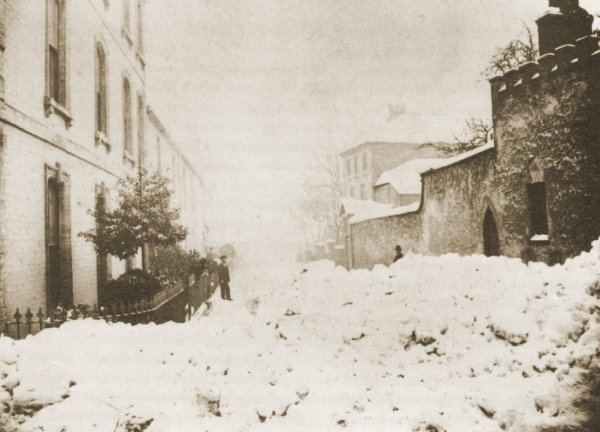
Peter Street blocked by 'The Great Snow' of 1881 as seen from Union Street. This photograph was almost certainly taken by Henry Stiby who was a keen amateur photographer and left a good record of photographs of Yeovil - he lived in Clarendon House, the house seen at extreme right with the crenellated parapet, on the corner of Peter Street and Union Street, at the time.
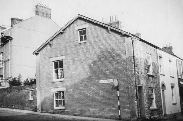
Photographed around 1965, Peter Street runs off to the left and Bond Street to the right. The corner house is now the shop Sports of Bond Street.
The north side of Peter Street in a colourised photograph of 1968. All these houses except that at extreme left (see photograph after next) were demolished and the area is now a car park.

This
photograph
features in my
book "Lost Yeovil"
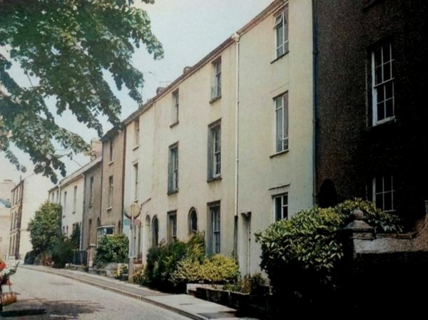
Peter Street photographed in the 1970s from the Union Street (western) end.
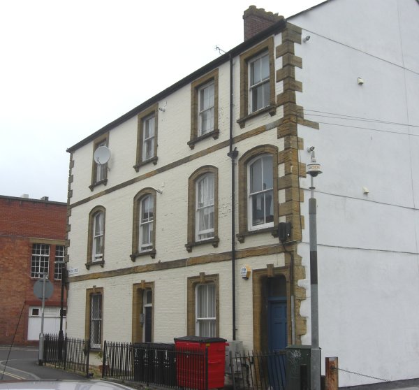
The only surviving houses on the north side of Peter Street. This pair of houses date to the late 1880s. Photographed 2013.
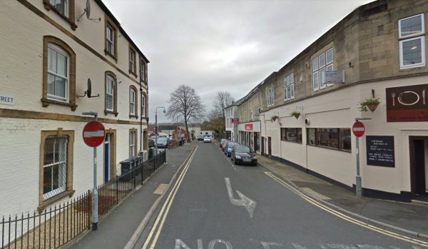
Peter Street, seen from Union Street in 2015.