Rope Making
rope making in yeovil
A long-standing small local industry
Making rope and twine, and the associated trades of manufacturing webbing and sacking, was established centuries ago in Yeovil and continued into the twentieth century. Common natural fibres used in rope making were manila hemp, hemp, linen, cotton, coir, jute, straw, and sisal. As early as 1587 the Woborn Muniments recorded William Beacham as a Sackweaver at the Dye House and in 1622 the Muniments recorded John Beacham, presumably William's son, continuing as a Sack Weaver at the Dye House. Unfortunately the location of the Dye House is unknown. A deed dated 1678 recorded John Jacob as a Roper and a similar deed dated 1705 recorded John Newman as a Roper.
From 1709 until 1720 the Churchwarden's Accounts record payments to James Foot, Rope Maker, almost annually for the supply of bell ropes to St John's church. From 1765 James Foot, presumably either the son or grandson of the above James, was recorded again almost annually for the supply of bell ropes until 1785. From 1786 until 1817 the Churchwarden's Accounts record payments to Thomas Jesty for supplying the bell ropes. Whether Jesty took over Foot's business in 1786 or the Churchwardens simply changed supplier is unknown.
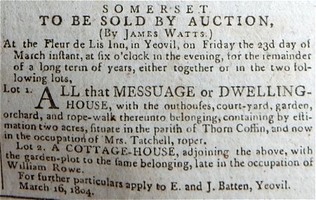
The Yeovil Poll Book of 1733 listed William Nail (Neal) as a Roper of Wigdon & Huntley. There were certainly other rope makers in Yeovil at this period since the Churchwardens also bought ropes from William Neal and Mrs Tatchell, both described as Ropers, in 1790. Mrs Tatchell was a roper and, certainly in 1804 (see Gallery), occupied a ropewalk in Thorne Coffin. A sole reference is found in Pigot's Directory of 1824 which lists John Palmer as a Sack, Sacking and Twine Manufacturer of of Kingstone. The Jury List of 1827 refers to John Farley as a Rope & Twine Manufacturer of Reckleford. Farley is mentioned in the Churchwardens' Accounts of 1836 and in 1839 was listed in the Sherborne Journal.
John Neal (William's son or grandson?) is recorded as supplying ropes to St John's church, at the same time as Thomas Jesty, from 1806 until 1836. John Neal is referred to in the accounts variously as a Rope Maker, Rope Manufacturer and Rope Supplier. He was recorded as a Sack, Sacking & Twine Manufacturer in Pigot's 1824 Directory and as a Sacking Manufacturer in Pigot's Directory of 1830. Neal's rope works were in Reckleford and a rope walk is shown running parallel to Reckleford Hill on Watt’s map of 1831. It was on the south side of today's Reckleford, opposite Goldcroft (see maps below), but in 1848 his rope factory was destroyed by fire. The site of the rope works was built on by William Tucker in the 1890s and became Salisbury Terrace.
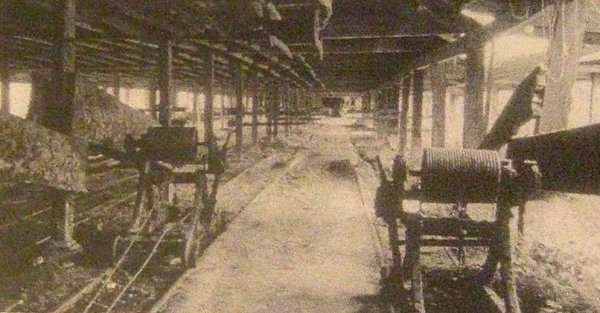
A ropewalk was a long straight narrow lane or a covered pathway, where long strands of material were laid before being twisted into rope. Ropewalks historically were harsh sweatshops, and frequently caught on fire, as hemp dust forms an explosive mixture. Rope was essential in sailing ships and the standard length for a British Naval Rope was 1,000 feet (305 m). A sailing ship such as HMS Victory required over 20 miles (32 km) of rope. Other rope walks were located at Fair Ground between North Lane and Court Ash, with another running alongside the eastern edge of Mount Pleasant. The Mount Pleasant Rope Walk (sited in a field originally called Drang and shown on the 1842 Tithe Map as Parcel 994) showing on Ordnance Survey maps of 1886 and 1901.
Roping Path, between Higher Kingston and Sparrow Lane, had been the site of an 18th century rope and twine works mentioned in the Terrier of 1743 as 'Ropeing Field and Yard'. The name of the place is an obvious reference to the trade being carried out there. John Tatchell owned a rope factory in Higher Kingston in the early 19th century which may have been this factory - presumably running alongside Roping Path close to its junction with Higher Kingston. After the fire in Neal's rope works, Tatchell took over Neal's company and moved his production from Higher Kingston to Wellington Villa in West Hendford. Tatchell was last recorded as a Rope & Twine Maker of Huish in Slater's Directory of 1852.
A deed of 1805 is the sole reference to a roper named William Jeans but between 1849 and 1856 several references are made in the Churchwardens' Accounts to William Jeans, the son, as a Rope Maker / Supplier and Slater's Directory of 1852 lists him as a Rope & Twine Maker of Middle Street. Jeans & Son were noted rope makers of Middle Street and were listed frequently until 1856.
The Post Office Directory of 1875 listed John Adams as a Rope & Twine Manufacturer of Middle Street and Whitby's Yeovil Almanack Advertiser of 1882 mentioned Joseph Adams (actually John) as a Rope Maker of 104 Middle Street.
The 1882 edition of Whitby's also listed Henry Good as a Twine Manufacturer of 22 Hendford and by 1895 Whitby's was listing Good & Co as a Twine Manufacturer at the Patent Twine Works. The Patent Twine Works were located opposite Horsey Lane, just the other side of Dodham Brook from the Railway Hotel. In Whitby's 1898 edition Good & Co were listed as Twine Manufacturer & Steam Laundry.
In Whitby's 1898 edition Henry Thomas Adams, son of John Adams listed above, was listed as a Twine Manufacturer of 104 Middle Street. Henry was listed in various trade directories until his final listing in Kelly's Directory of 1919. This was also the last time that rope or twine manufacture was listed in any Yeovil trade directory.
maps
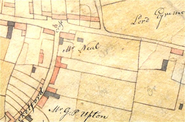
E Watts' map of 1806 shows Reckleford running across the top while Rackleford (today's market Street) runs from it down to the bottom left corner. The large corner site annotated 'Mr Neal' at this time referred to John Neal, the son of William Neal.
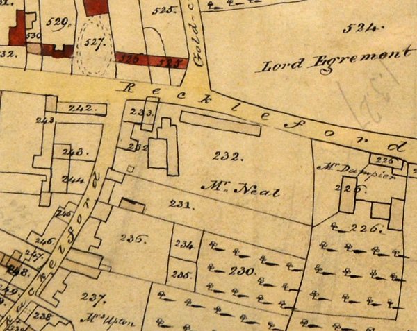
E Watts' later map of 1831 shows that, by this time, John Neal had constructed a covered rope-walk running parallel to Reckleford (possibly replacing an earlier open-air rope-walk) with possibly a second rope-walk and other associated buildings at right angles to it.
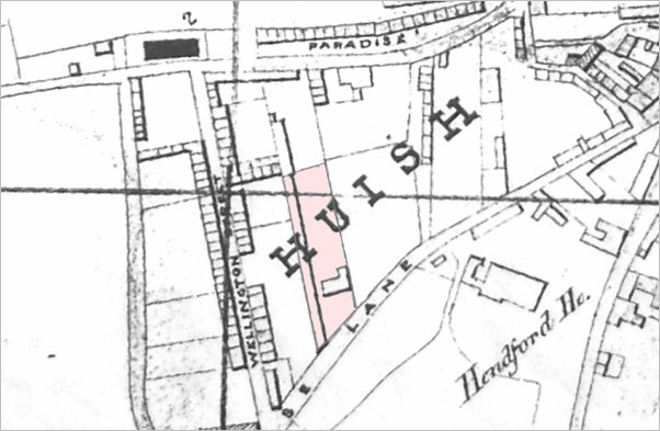
An extract of Hickes & Isaac's map of Yeovil of 1858 showing, in pink, the land of John Tatchell's Wellington Villa. The rope walk was the long strip at the west of the site, beneath the 'H' of Huish. West Hendford (annotated on this map as Horse Lane) runs from top right to centre bottom.
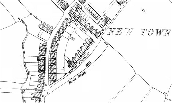
This map, based on the 1901 Ordnance Survey, shows the rope walk alongside Mount Pleasant with a building at the top and another half-way. Much of the site would have been in the open air as shown in the second photograph below.
gallery
From my
collection
A notice of sale of Mrs Tatchell's rope-walk, etc. at Thorne Coffin from the 19 March 1804 edition of the Western Flying Post.
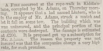
This report of a fire at the Mount Pleasant Rope Walk is from the 5 June 1868 edition of the Western Gazette.
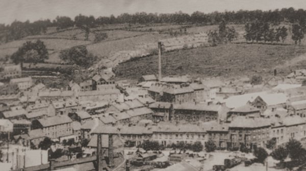
In the top half of the photo, Kiddles Lane (today's Eastland Road) runs left of the chimney with fields either side!!! Behind the chimney is Mount Pleasant and the dark hedgerow in front of the houses marks the site of the rope walk that extended to the trees at right.
This photograph dates to about 1900 and shows, at centre, the chimney of the Eastland Road brickworks with its associated buildings clustered around its base. To its left is the leather works built by William Bide (recogniseable by the double roof with a row of six black windows). Running along the bottom of the photograph is Station Road with the Alexandra Hotel at bottom right.

John Tatchell's home, Wellington Villa in West Hendford, photographed around 1960. The swimming pool is being constructed behind Wellington Villa on what would have been Tatchell's rope walk. At right is Morley House that survives today.
This
photograph
features in my
book "Lost Yeovil"
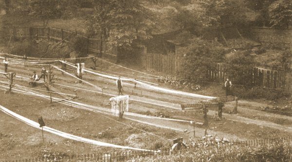
Although not in Yeovil, this photograph dates to around 1900 and illustrates a typical rope walk.
An illustration of a covered ropewalk - actually Dawe's ropewalk, West Coker. Photographed around 1980.