yeovil brick works & Brick makers
yeovil brick works & Brick makers
Producing Yeovil's bright red bricks
 Yeovil clay
was suitable for
brickmaking and
several
brickworks were
to be found in
the town
producing the
soft, bright red
bricks found
everywhere in
the older parts
of the town.
Certainly in
1838 a
contingent of
Yeovil
brickmakers
marched (albeit
at the end) in
the grand
procession
through the
streets of
Yeovil to mark
the Coronation
of Queen
Victoria.
Yeovil clay
was suitable for
brickmaking and
several
brickworks were
to be found in
the town
producing the
soft, bright red
bricks found
everywhere in
the older parts
of the town.
Certainly in
1838 a
contingent of
Yeovil
brickmakers
marched (albeit
at the end) in
the grand
procession
through the
streets of
Yeovil to mark
the Coronation
of Queen
Victoria.
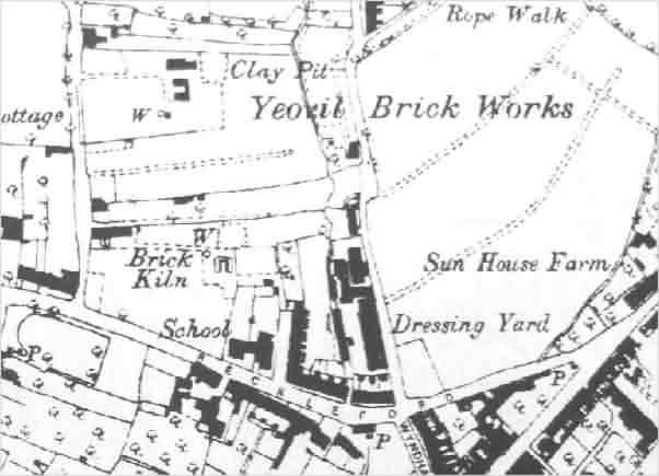
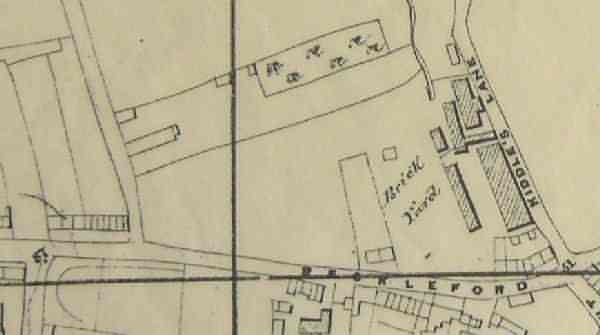
The main Yeovil Brickfields (see No 7 below) were located north of Reckleford in the general area of Eastland Road, at this time known as Kiddle's Lane. The map below shows a clay pit from which the raw material was obtained as well as a brick kiln to the northwest of Dampier Street and to the east of Kiddle's Lane. The brickworks closed during the late-nineteenth century and building on the site began in 1889 with the construction of Wayside Terrace on the west side of Eastland Road, just to the left of the 't' of Clay Pit on the map below. Much of the site to the west being covered by the Nautilus Works, completed by 1913, and land to the east being occupied by Westville, Southville and Eastville.
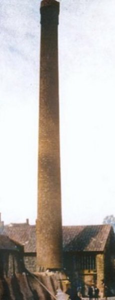
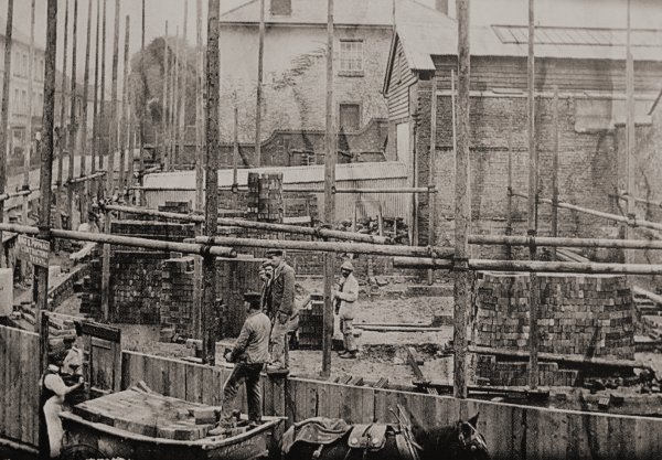
Later Ordnance Survey maps show extensive buildings connected with the brickworks close to the corner of Kiddle's Lane and Reckleford, where the school now stands. This was the brick works of the Yeovil Brickfields Co Ltd established around 1900. The chimney and the brickworks complex on the corner of Kiddles Lane and Lower Reckleford were demolished (see photo at left and below) in 1912 to make way for the Central Junior School.
Extensive brickworks were also to be found at St Michael's Avenue which, indeed, was originally known as Brickyard Lane. The section from Milford Lane to Mudford Road was still called Brickyard Lane on the 1928 Ordnance Survey.
There were several other, smaller brickworks in the town such as at New Town, Preston Road and Ilchester Road.
Most of the
Yeovil
brickmakers (Brian Murless has
identified
twelve, to which
I've added several
more, see
below) were
small in scale
and didn't last
for long. The
Ordnance Survey
marks single
kilns such as
those at King
Street (No 6
below) and New
Town (No 11
below) and this
suggests
short-term
investment by
builders and
others to meet
local needs,
especially the
new housing that
was being
erected in the
latter part of
the nineteenth
and early
twentieth
centuries. Not only
that, but the
majority of
Yeovil's brick
makers were
already in the
building trade
BRICK MAKERS
The following is a list of known Yeovil brick makers. Those identified by Brian Murless in 'Somerset Brick & Tile Manufacturers - A Brief History & Gazetteer' are indicated with an asterisk after their name and those whose names are in red have their own pages in this website - just click on the name.
-
William
Baker
*
(1802-c1870)
of
Back
Kingston
Active - listed in Robson 1839, Pigot 1842, Hunt 1850, Slater 1852/3, Harrison, Harrod & Co 1859, Kelly 1861
William Baker was born in Broadclyst, Exeter, Devon in 1802 but had moved to Yeovil by 1833. Between 1839 and 1842 he ran a beerhouse called the King's Arms in Back Kingston (today's Higher Kingston) with his wife Elizabeth. Pigot's Directory of 1842 listed him as a 'Brick Maker & Lime Burner'. The Yeovil Tithe Apportionment of 1846 noted him as the occupier of Parcel 1457, described as 'Brickyard, etc' owned by John Moody (see Brickyard 1 below). This was on Preston Road to the immediate east of the Workhouse - the site is now occupied by Westfield Road. The 1851 census lists him as a widower living in Back Kingston with his son, also William, and he listed his trade as a 'Contractor of Roads, etc'. In the 1861 census he was listed as an 'Earth Contractor'. He died in either 1870 or 1872.
See also the Gallery below.
-
Edwin
Bartlett
*
of 69
Hendford and
Mudford
Kelly 1889 to 1902 inclusive, Whitby 1895 (as Builder, Brickmaker & Undertaker)
Edwin Bartlett was born in Hardington Mandeville in 1831, son of carpenter Robert Bartlett and his wife Ann. In 1851 the family were living in West Coker. In 1863 he married Charlotte Cragg at Marylebone, London, and they moved to Yeovil. The 1871 census recorded them living in Kingston with their three infant children and Edwin gave his occupation as Builder. By 1881 William and Charlotte were living at 76 South Street with their seven children and a servant. Edwin listed his occupation as 'Builder, employing 16 men and 7 boys'. In 1882, he bought the Mudford brickworks of Henry Harwood. By 1891 the family were living at 69 Hendford (next door to Hendford House, today's Manor Hotel) and Edwin gave his occupation as Builder. In Whitby's Yeovil Almanack Advertiser of 1895 he was listed as a 'Builder, Brickmaker & Undertaker'. Edwin died in 1907.
-
Richard
Bicknell
*
(1854-1929)
of
Brickyard
Lane
(today's St
Michael's
Avenue)
Kelly 1906 to 1919 inclusive
Richard Bicknell was born in Mudford in 1854, the son of agricultural labourer Richard Bicknell and Ann née Whittle. In 1871 17-year old Richard was listed as an agricultural labourer like his father. In 1875 Richard married Rebecca Emma Carey Gulliford at Wincanton and in the 1881 census they were listed in Mudford with their two young children. During the 1890s Richard Bicknell was one of the Overseers of the Poor of the parish of Yeovil (without).
In the 1901 census Richard and Rebecca, together with their seven children, were living in Brickyard Lane - one of only three families there. Richard listed his occupation as 'Brick Maker' and was noted as working 'at home' (see map below). His eldest son 17-year old Wilfred, was a 'Carter in Brickyard'. The family were still living in Brickyard Lane in 1911 at which time Richard gave his occupation as 'Brick Manufacturer & Road Contractor'. Richard Bicknell, described as a farmer of Allingham House, Brickyard Lane, was declared bankrupt in 1923 and died in Yeovil in 1929 aged 76.
-
Henry Blake
* of Newtown
Kelly 1883. Ordnance Survey shows brick kiln as 'Disused' in 1886.
Henry Blake was born in Yeovil in 1820. In the 1851 census he was listed living in Back Kingston with his wife Mary, twelve years his senior. He gave his occupation as a labourer while she ran a 'Dame School' of 20 children. I lost them in the returns for 1861 and 1871 but by 1871 they were living in Goldcroft and 60-year old Henry listed his occupation as a Brick Manufacturer. Henry Blake died in Yeovil in 1894 aged 75.
-
Amos
Haimes
*
of Kingston
Pigot 1822 and 1823
I could find no further information on Amos Haimes other than he died in 1840 in Lyneham, Wiltshire.
-
GT
Hardy
brickmaker
of Yeovil
Western Gazette, 29 May 1874
Applied for the position of Inspector of Nuisances for the Union. Only received one vote out of a possible 38.
-
Joel
Hardy
*
of London
Road
Robson 1839, Pigot 1842
Joel Hardy was born in Uplyme, Devon, on 21 July 1782, the son of Thomas and Mary Hardy. On 28 July 1811 Joel married Melina Seward at St Johns church, Yeovil. They lived at Penn-Field, London Road and Joel was listed in the Poll Books of 1832 to 1846 by virtue of owning a freehold house there. Robson's Directory of 1839 listed him as a Brick Maker and also as a Brewer of London Road - the later Royal Osborne Brewery. Joel Hardy died in Yeovil on 18 September 1861.
-
George
Harris
*
of Victoria
Place
Robson 1839, Bragg 1840, Pigot 1842, Slater 1852/3, Kelly 1861
George Harris was born in Yetminster, Dorset, in 1792. The 1846 Yeovil Tithe Apportionment noted that George owned and occupied two parcels of land; 1065 Roping Path and 1066 adjoining Mudford Road to the immediate south of Green Quarry, noted as 'Brickyard, etc' (see map below). In the 1851 census George and his wife Grace, together with their son, daughter and grandson, were living in Victoria Place. George listed his occupation as 'Timber Merchant'. By 1861 69-year old George was still living in Victoria Place with Grace and daughter Elizabeth. He gave his occupation as Builder. By 1871 George, now widowed and aged 79, had moved around the corner and was living with his daughter in Clarence Street. He gave his occupation as 'Income from Houses'.
-
Charles
Harwood
*
of Vicarage
Street and
Mudford
Harrison, Harrod & Co 1859, Kelly 1866, Morris & Co 1872, Kelly 1875
Charles Harwood was born in Yeovil in 1820, the son of mason Thomas Harwood. In 1845 he married Maria Morse at Yeovil and in the 1851 census they were living in Vicarage Street with their two infant children. Charles listed his occupation as a Mason. By 1871 Charles was an established builder and noted in the census that he employed '32 men and 10 boys'. He still lived in Vicarage Street with Maria and his father Thomas and a servant were living with them. Charles died in Yeovil in 1879 aged 59 and the Mudford brickworks were bought by Edwin Bartlett (see above) from Harwood's son, Henry.
-
Arthur Silas
Hayward
*
of 84 Gold
Croft Lane
Kelly 1902
Arthur Silas Hayward was born in Yeovil in 1862. In the 1891 census Arthur, aged 9, was listed living with his grandfather Silas Hedditch, a Middle Street umbrella maker. In the 1891 census Arthur was living at 13 Market Street with his aunt. Aged 28 he gave his occupation as 'Leather Glove Manufacturer'. I couldn't find him in the 1901 census but he died in Yeovil on 10 June 1907. His probate noted him as a Builder of Goldcroft and his estate was valued at £15,777 (around £8 million at today's value).
-
Samuel Isaac
(1783-1849)
Indenture dated 2 July 1814
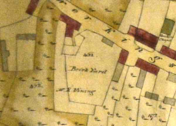
An indenture in my collection dated 2 July 1814 relates to the sale of a field to Robert Jennings (below) "lately converted into a Brickyard.... together with the Brick Kiln and all and singular other outhouse and buildings lately erected and built by the said Samuel Isaac". This was one of at least three brickyards after which Brickyard Lane (today's St Michael's Road) was named. The site of this brickyard (see '12' below) later became the White Horse public house. See also '8' below. Whether or not Isaac actually made bricks himself is open to question since he was described in the lease as a 'Gentleman' but, in fact, was a Yeoman farmer who lived in the farmhouse that would become the Glovers Arms and owned much land east of Ryalls Lane (today's Eastland Road).
-
Robert
Jennings
(1771-1848)
of Silver
Street
Pigot 1822, 1830
Robert Jennings was a plumber & glazier, an ironmonger, and Postmaster of Silver Street and was listed as a brick maker in Pigot's Directory of 1822. He also served as Yeovil's Portreeve. However an indenture in my collection dated 2 July 1814 shows him to have purchased from Samuel Isaac a brickyard with a brick kiln thereon (see '12' below) in Gorefield which he later leased (in 1829) to William Snook.
-
Henry
Longman
(1791-1844)
of Hollands
(1822) /
Kingston
(1830)
Pigot 1822, 1830
Henry Longman was born in 1791, in Abbas Combe, Templecombe. He lived in Hollands (actually Green Quarry) and was listed in Pigot's Directory of 1822 as a Brick Maker of Hollands. He was listed in the Yeovil Poll Books of 1832 and 1834 by virtue of owning freehold houses in Reckleford and again he was noted as living at Hollands. In the 1841 census 45-year old Henry was living at Green Quarry (technically opposite Hollands, but included in the general area of Hollands at the time) with his wife Mary née Maidment, daughter of George Maidment below. Henry listed his occupation as 'Collector of Rates'. Henry Longman died in the winter of 1844 aged 48.
-
George
Luckes,
also
recorded as
Buckes and
also known
as Wills
I have just one reference to George Luckes, aka Wills, brick-maker of Yeovil, from the Birmingham Gazette of 5 April 1824 when he was declared bankrupt.
-
George
Maidment
(1750-1820),
known to be
a stone
supplier as
well as a
brick maker
of the
Hollands
area until
his death in
1820. The
father-in-law
of Henry
Longman
above, to
whom he left
his
business.
-
Henry Penny,
Edward
Boucher and
Hugh Tinsley
The following advertisement appeared in the Sherborne Mercury, or Weekly Advertiser, Issue 21, dated Tuesday 12 July, 1737:
To be sold At YEOVIL in the County of Somerset, By Messieurs Henry Penny, Edward Boucher, and Hugh Tinfley, MAKERS.
All Sorts of BRICKS and TILES, via. Pan, Plain, Hip, Gutter, and Ridge Tiles: Bricks for Building or Paving made of fine durable Clay, and done in the most Workman-like Manner, at the following Prices, viz. Bricks at 16 Shillings a Thousand; Hollow Pantiles, at £2 10s. a Thousand, with which the Proprietor will undertake to cover any House as cheap as with Thatch; and Plain Tiles at £1 5s. Hips, Gutters, and Ridge Tiles at 1s.6d. a Dozen: Bricks for Paving well polish’d and jointed at £1 10s. a Thousand.
-
William
Snook
(c1780-1847)
A glove manufacturer, William Snook leased the Brickyard Lane brickyard from Robert Jennings (see above) in 1829, but most likely as a speculative venture.
-
Richard
Vining (1) -
(1752-1816)
of Kingston
Edward Bullock Watts' map of Yeovil of 1806 shows the brick yard (see '2' below) of Mr R Vining in Kingston at the location where his son would later build Kingston House (recently part of the Park School).
-
Charles
Vining
*
(1780-1855)
of Ilchester
Road and
Kingston
Pigot 1830 and 1842, Robson 1939
Charles Vining was son of the above Richard Vining. He was a Mason, a Master Builder and a Brick Maker and lived at Picket Witch House on Ilchester Road with the brickyard (see '2' below) in what is now the garden of the house.
Charles Vining has his own page here.
-
Richard
Vining (2)
*
-
(1815-1891)
of Ilchester
Road,
Kingston and
Princes
Street,
Yeovil and
Mudford.
Somerset
Gazette
Directory
1840 (as a
Flower Pot
Maker),
Bragg 1840,
Hunt 1850,
Slater
1852/3,
Harrison,
Harrod & Co
1859, Kelly
1861
Richard Vining was son of the above Charles Vining and grandson of the above Richard Vining (1). He was also a brick maker and has his own page here. He committed suicide by drowning. See also the Gallery below.
-
Yeovil Brickfields Company Limited of Reckleford
Kelly 1902 to 1910 inclusive
BRICKWORKS
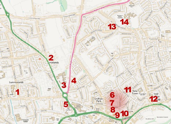
KEY MAP - Locations of the Yeovil brickyards, etc. The pink-shaded area is noted on the 1886 Ordnance Survey as the 'Yeovil Brick Works' which certainly included 7 and most likely 8.
For details on historic land measurement used below (ie acres, roods and perches) click here.
![]()
1: Brickyard, Summerlands
National Grid
Reference:
ST 54654 16573
X (easting)
354654, Y
(northing)
116573
Somerset
Historic
Environment
Record Ref:
54776
William Baker (see above) was one of several Yeovil brick makers and was listed as such in Robson's Directory of 1839. Pigot's Directory of 1842 listed him as a 'Brick Maker & Lime Burner' and he was also listed as a brick manufacturer in Hunt's Directory of 1850, Slater's 1852/3 Directory, Harrison, Harrod & Co's 1859 Directory and finally in Kelly's Directory of 1861. From this, the brickyard most likely had a lime kiln and a brick kiln. Indeed, in a report of 1859, Hickes & Isaac noted that the brickyard had two kilns.
The brickyard was bounded on the south by Preston Road, on the west by the Union Workhouse, to the north by Middle Marle Close (Parcel 1440a) and to the east by Grove Cottage (Parcel 1458) and the un-named plot of ground behind the cottage (Parcel 1459).
Today the site of the Brickyard (Parcel 1457) is occupied by the houses and gardens of Westfield Road as it joins Preston Road.
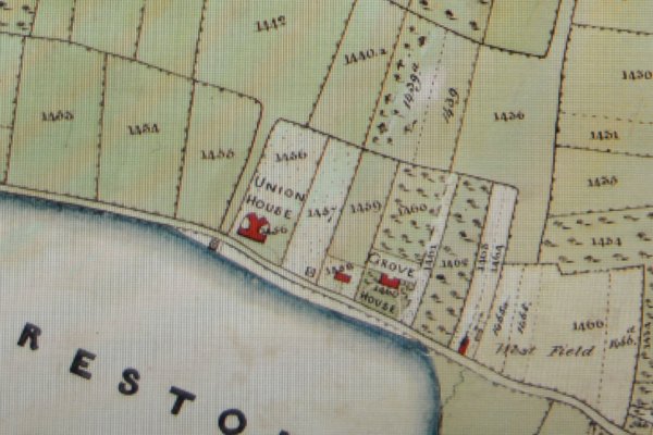
A section of the 1842 Tithe Map showing Preston Road running from centre left to bottom right with the Union House at centre. To its immediate right, Plot 1457 noted in the 1846 Tithe Apportionment as the "Brickyard, etc" owned at the time by John Moody with William Baker as tenant. It measured 2a 2r 2p.
![]()
2: Brickyard, Picket Witch
National Grid
Reference:
ST 55117 17010
X (easting)
355117, Y
(northing)
117010
Somerset
Historic
Environment
Record Ref:
54775
Charles Vining (see above) was recorded in the 1832 poll book as living at Picketwitch - not the late pub of that name, but a large house in the vicinity known as Picket Witch House. This was the home of Charles Vining until his death in 1855, and then his son Richard Vining (2). According to the 1846 Tithe Apportionment, the brickyard was located next to the house in Parcel 1083, on the map below. The 1846 Tithe Apportionment recorded Parcel 1083 as 'House Garden and Brickyard' measuring two acres. The property was owned by Charles Vining (see above) and was occupied by his son Richard Vining (2) who was manufacturing bricks, tiles, chimney pots, flower pots etc. on the site.
In the 1861 census, Richard Vining (2) gave his occupation as 'Brick & Tile Manufacturer & Town Surveyor'. The 1871 census noted 55-year old Richard gave his occupation as 'Surveyor and Land Agent', so presumably the brickyard ceased production during 1860s
Today, the site remains the gardens of Picket Witch House.
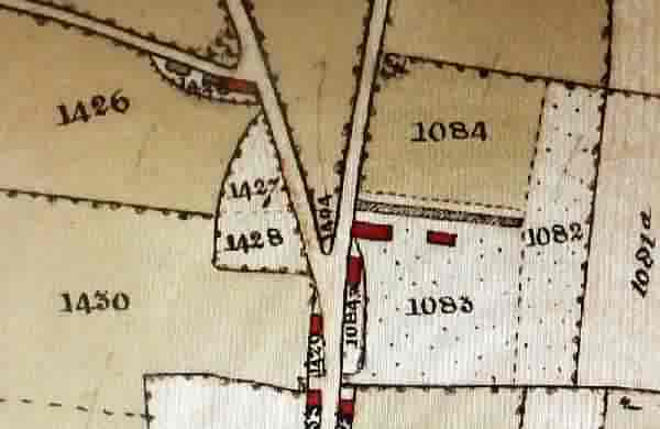
This extract of the 1842 Tithe Map shows the Ilchester Road coming from centre bottom before Marsh Lane splits off to the right. Parcel 1083, 'House Garden and Brickyard', was owned and occupied by Charles Vining and then his son Richard Vining (2) - see above.
![]()
3: Brick Clay and Stone - Hollands
National Grid
Reference:
ST 55319 16629
X (easting)
355315, Y
(northing)
116636
Somerset
Historic
Environment
Record Ref:
41377
It would appear that by 1830, Henry Longman (see above) leased the three-acre pasture between Hollands House and the Fiveways crossroads, labelled Parcel 580 on the map below. This was owned by Henry Etheridge and the Dorset County Chronicle, in its edition of 4 March 1830, advertised a sale of Etheridge's land holdings including "Lot 2. A valuable Close of Pasture Ground, called Hollands, situate near the town of Yeovil, by estimation 3 Acres, with the Stable thereon, in the occupation of Mr Henry Longman. Good brick clay and excellent building stone may be found on this lot."
It seems, therefore, that Henry Longman may have been sourcing his clay here for use in his brick yard (see No 4 below) south of Green Quarry (Parcel 1066).
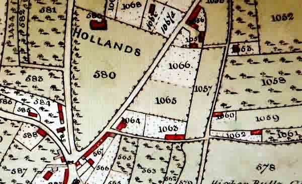
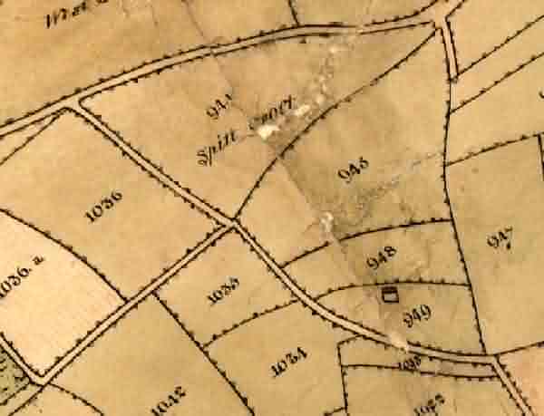
A section of the 1842 Tithe Map showing the Five Crossroads at bottom left. Parcel 580 and its house, Hollands House, was the property and residence of solicitor John Batten in the 1840s, but in the late 1820s and early 1830s the 3-acre pasture of Parcel 580, was owned by Henry Etheridge. Etheridge leased the pasture to Henry Longman where "Good brick clay and excellent building stone may be found on this lot."
The brickyard (see No 4 below) of George Maidment (see above), and later Henry Longman (see also above), was Parcel 1066 at centre. This was to the immediate south of Green Quarry. Although the brickyard is often listed as Hollands, this was the name of the general area.
![]()
4: Brick Works - Green Quarry (Hollands)
National Grid
Reference:
ST 55429 16723
X (easting)
355429, Y
(northing)
116723
Somerset
Historic
Environment
Record Ref:
The brickyard of George Maidment (see above), later Henry Longman (see also above), and later still George Harris (see also above) was Parcel 1066 at centre of the map above. This was to the immediate south of Green Quarry. Although the brickyard is often listed as Hollands, this was the name of the general area and I've labelled No 4 as Green Quarry to differentiate it from No 3 above.
George Maidment occupied the brickyard until his death in 1820 and it was bequeathed to his son-in-law, Henry Longman, who was the owner-occupier until the 1840s.
By the mid-1840s George Harris was operating the brickyard. The 1846 Tithe Apportionment noted that Harris was both owner and occupier. George Harris also owned Parcel 1065, a field called Roping Path, and the houses and gardens of Parcel 1063 off Sparrow Lane.
The site of the former brickworks is now chiefly occupied by the sheltered housing scheme, Pearson House, on the extension of Roping Road, north of Sparrow Road.
![]()
5: Brickyard, Kingston
National Grid
Reference:
ST 55371 16360
X (easting)
355376, Y
(northing)
116303
Somerset
Historic
Environment
Record Ref:
Brick maker Richard Vining (1) (1752-1816) owned and operated a brick yard in Kingston, close to Fiveways and is clearly shown and annotated on Edward Bullock Watts' 1806 Yeovil map below.
Charles Vining (see above), the son of Richard Vining (1), built Kingston House on the site of his father's brickyard, probably in the 1830s. This became the home of his own son, solicitor James Tally Vining, at least from 1842. It later became part of the Park School.
An extract of Edward Bullock Watts' 1806 Yeovil map with Fiveways at top left and Kingston running diagonally across the map. The Vining's brickyard is clearly located lower left of centre, at this time belonging to Richard Vining (1).
An enlargement of the previous 1806 map showing with greater clarity, the brickyard of Richard Vining (1) - as far as we know, he was the first of three generations of Yeovil brickmakers..
![]()
6: Brick Kiln - King Street
National Grid
Reference:
ST 55958 16545
X (easting)
355958, Y
(northing)
116545
Somerset
Historic
Environment
Record Ref:
41378
This brick kiln seems to be a short-lived local enterprise and only appears on the 1901 and 1903 editions of the Ordnance Survey. It was probably created to make bricks for the first houses of the western half of King Street, which initially appears as a cul-de-sac at the top of the hill, off Goldcroft, in the 1904 Ordnance Survey. From newspaper advertisements it is known that the houses at the western end of King Street had been built and were being sold off in May 1903. It further appears that the houses had been built by the Yeovil building firm of Bird & Pippard, who may, therefore, have constructed the brick kiln for their own purposes.
Possibly connected to this brick kiln (or possibly not), it should be pointed out that Bird & Pippard also constructed the Western Gazette building in Lower Middle Street between 1902 and 1906, using 600,000 bricks. Although it is not known for certain where these bricks were sourced, they were certainly delivered to the Western Gazette building site in their own carts (see photo below).
Today the site of the brick kiln is built on with the houses at the middle of King Street, just before the junction with Crofton Avenue.
An extract of the 1901 Ordnance Survey showing the 'Old Brick Kiln' (No 7, below - the clay pit appears to have been filled in) at lower left, to the west of New Town. At top left is the brick kiln (No 6) - the newly-built King Street was just off-map to the left of the kiln.
The early days of construction of the new Western Gazette building, circa 1903, with some of the 600,000 bricks being unloaded from the horse-drawn delivery cart of Fred Bird. The construction company was Bird & Pippard, builders and undertakers of Middle Street. Did these bricks originate from the brick kiln by King Street during this three-year building project?
![]()
Yeovil Brick Works, north of Reckleford
The Yeovil Brick
Works is the
area shaded pink
on the Key Map
above.
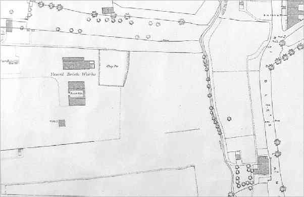
It appears (to me, at least) that the Yeovil Brick Works grew over relatively few years (from at least 1886 until around 1900) and over an extensive area, including No 7 (Goldcroft north) and No 8 (by Dampier Place) below, as well as tracts of land to the east of Eastland Road - as indicated by the size of the 'Yeovil Brick Works' on the map below.
An extract of the 1890 Ordnance Survey showing 'Yeovil Brick Works' spanning either side of Eastland Road. The 'Clay Pit' at top, left of centre, is No 7 - Goldcroft north (see below) and the 'Brick Kiln' at centre left is No 8 - by Dampier Place (see also below).
![]()
7: Yeovil Brick Works (Goldcroft north)
National Grid
Reference:
ST 56012 16378
X (easting)
356012, Y
(northing)
116378
Somerset
Historic
Environment
Record Ref:
31931
The sub-divided building, brick kiln and clay pit, labelled 'Yeovil Brick Works' first appears on the 1886 Ordnance Survey. I assume this to be the centre of the 'Yeovil Brick Works' as it appears to have offices or workshops as part of the complex. Perhaps the wider area of the works included clay deposits to the east of Eastland Road as suggested by the previous map of 1890.
By the time of the 1903 Ordnance Survey it was labelled 'Old Brick Kiln', suggesting it was no longer used.
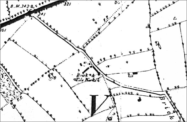
From the 1886 Ordnance Survey showing the Yeovil Brick Works at centre left comprising a long subdivided building with a clay pit to the east and a brick kiln to the south. For location purposes, Kiddles Lane (today's Eastland Road) runs up the right side and at the top right Mount Pleasant runs off to the top right corner.
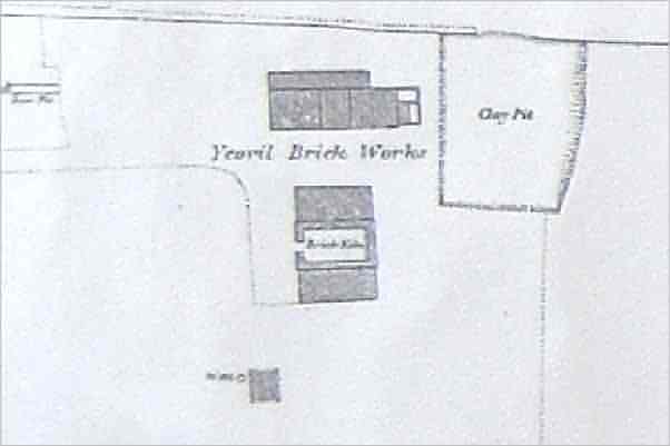
The Yeovil Brick Works enlarged for clarity from the previous image.
![]()
8: Brick Kiln, by Dampier Place
National Grid
Reference:
ST 56020 16253
X (easting)
356020, Y
(northing)
116253
Somerset
Historic
Environment
Record Ref:
31927
I consider this to be a subsidiary kiln of the Yeovil Brick Works (the area shaded pink on the Key Map above).
This brick kiln did not appear on Hickes & Isaac's map of 1858 (see map on '9' below).
The 1886 Ordnance Survey shows this as a rectangular structure, with an entrance to the south. Although it might be considered that the kiln lay within the bounds of the Nautilus Works (which it does today, although the site has recently been cleared), the 1886 map below does tend to indicate that it was fenced of from the Nautilus Works and that it was accessed from the extension of Dampier Street.
The 1903 Ordnance Survey still shows the structure, albeit un-named.
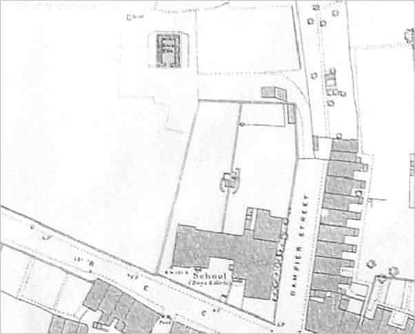
An extract from the 1886 Ordnance Survey with Reckleford running across the lower left quadrant. The brick kiln (8) is seen at top, just left of centre. Dampier Street would be extended within the following ten years and the four cottages of Dampier Place, which remain today, would be built to the right of the brick kiln.
![]()
9: Brick Yard, Reckleford
National Grid
Reference:
ST 56100 16200
X (easting)
356100, Y
(northing)
116200
Somerset
Historic
Environment
Record Ref:
41379
Edward Bullock Watts' map of 1842 noted that this land was the property of Samuel Isaac (see above). The 1846 Tithe Apportionment noted that Parcels 533 and 534 were owned by Samuel Isaac and let to Henry Bryant Phelps as orchards.
However, a brick yard on the site does not appear until Hickes and Isaac's map of 1858 (see map below). It does not appear on maps after this date, and by 1886 Dampier Street had been built on the plot. It is now the site of Perry Place, on the eastern side of Dampier Street.
From Hickes & Isaac's map of 1858, showing the brick yard at centre right between gardens to its west and the leather and glove factory of William Bide to the east on Kiddle's Lane (today's Eastland Road).
![]()
10: Yeovil Brickfields Co Ltd, Eastland Road
National Grid
Reference:
ST 56178 16213
X (easting)
356178, Y
(northing)
116213
Somerset
Historic
Environment
Record Ref:
The brick works of the Yeovil Brickfields Co Ltd was established, around 1900, on the southeast corner of Eastland Road as it abuts Reckleford. One of the management team was Frank Whitmash Mayo and the manager of the brick works was John Emlyn Davies.
The brick works was demolished in 1912 and the Central Junior School was erected on the site.
See the photograph of the brick works' chimney at the top of this page, and the brick works' buildings in the gallery below.
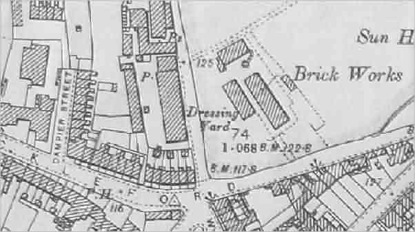
The 1903 Ordnance Survey shows the brick works of the Yeovil Brickfields Co Ltd at right of centre.
![]()
11: Brick Kiln - Smith's Terrace
National Grid
Reference:
ST 56216 16565
X (easting)
356216, Y
(northing)
116565
Somerset
Historic
Environment
Record Ref: None
This brick kiln appears on the 1886 Ordnance Survey of New Town, where it was marked as "Brick Kiln (Disused)". By the time of the 1889 OS, the brick kiln had disappeared. By 1903, the Ordnance Survey showed Smith's Terrace, as seen below.
It is almost certain that this brick kiln was established to create bricks for the new speculative housing that would become New Town. The most likely person to run the kiln was Henry Blake (see above) who, in 1871, lived in Goldcroft and gave his occupation as a brick manufacturer.
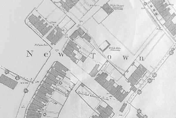
An extract of the 1886 Ordnance Survey map showing "Brick Kiln (disused)" at centre, above the 'To' of 'Town'.
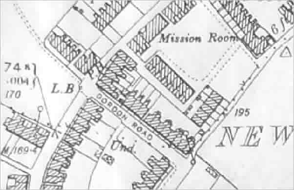
An extract of the 1903 Ordnance Survey map showing the brick kiln having been replaced by Smith's Terrace.
![]()
12: Brickyard, Goar Knap
National Grid
Reference:
ST 56572 16436
X (easting)
356572, Y
(northing)
116436
Somerset
Historic
Environment
Record Ref:
34759
This was one of three brickyards that gave Brickyard Lane (today's St Michael's Avenue) its name. See also 13 and 14 below.
An indenture in my collection dated 2 July 1814, shows Samuel Isaac (see above) to have sold to Robert Jennings (see also above) a brickyard for the sum of £201 5s (around £150,000 at today's value) on land to the south of land already owned by Jennings for the "absolute purchase of the same piece or parcel of land with the Brick Kiln and other new erections and buildings now standing and being thereon". The land was described as "All that piece or parcel of arable land containing by estimation one acre... situate lying and being in Gorefield (Goar Knap) in the parish of Yeovil aforesaid lately converted into a Brickyard bounded on the north by the land of the said Robert Jennings and on the South by lands of James Tucker together with the Brick Kiln and all and singular other outhouse and buildings lately erected and built by the said Samuel Isaac and now standing and being thereon...".
A second indenture, dated 3 August 1829, in my collection refers to the lease of properties leased for one year by Robert Jennings 'Plumber & Glazier' to glove manufacturer William Snook (see above), although Snook doubtless saw this as a speculative venture as opposed to an opportunity to create his own bricks. The indenture refers to "All that piece or parcel of Arable Land containing by estimation one Acre (be the same more or less) situate lying and being in Gore Field aforesaid sometime since converted into a Brick Yard... with the Brick Kiln and all and singular other the erections and buildings now standing or being thereon All which said premises are now in the possession or occupation of the said Robert Jennings or his undertenants...".
It would appear, therefore, that this brickyard was in operation by about 1810 but had closed by 1851 when the first incarnation of the White Horse opened on the site of the old brickyard.
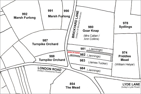
This map, based on the 1842 Tithe Map, shows the parcels of land referred to in the indenture of 1814 above. Parcel 982 was that parcel "lately converted into a Brickyard" by Samuel Isaac, Parcel 981 contained New Prospect Place built and owned by Robert Jennings (his son William had inherited the lands by 1846) - "bounded on the north by the land of the said Robert Jennings". Parcel 983 was "on the South by lands of James Tucker" - this is now the site of Great Western Terrace.
![]()
13: Brick & Tile Works, Brickyard Lane north (west)
National Grid
Reference:
ST 56007 17525
X (easting)
356007, Y
(northing)
117525
Somerset
Historic
Environment
Record Ref:
54773
In the 1901 census Richard Bicknell (see above) and his family were living in Brickyard Lane - one of only three families there. Richard listed his occupation as 'Brick Maker' and was noted as working 'at home' (see map below). His eldest son 17-year old Wilfred, was a 'Carter in Brickyard'. The family were still living in Brickyard Lane in 1911 at which time Richard gave his occupation as 'Brick Manufacturer & Road Contractor'. Richard Bicknell was described as a farmer of Allingham House, Brickyard Lane, when he was declared bankrupt in 1923 and it is assumed that his brick and tile works closed before this time.
See the Gallery for an example of the company's work - a pier cap with their stamp embossed.
Although the Somerset Historic Environment Record suggests this was "likely to have extended across the road from the east" (that is, 14 below) this is most unlikely since more than sixty years separated the use of the two facilities.
The former brickyard is now the site of Bicknell Gardens.
A part of the 1889 Ordnance Survey map featuring, as a thick black line at top left, Mudford Road and running diagonally across the map is Brickyard Lane, today's St Michael's Avenue. At centre is the "Brick & Tile Works". This had been Parcel 1035, named Gillard's Close, in the 1846 Tithe Apportionment, at which time it was owned by Ann Collins and occupied by James Marten. This brickyard, owned by Richard Bicknell, is now the site of Bicknell Gardens.
![]()
14: Old Brickyard, Brickyard Lane north (east)
National Grid
Reference:
ST 56168 17550
X (easting)
356168, Y
(northing)
117550
Somerset
Historic
Environment
Record Ref:
54773
The Tithe Apportionment of 1846 noted that Parcel 948, at centre right on the map below, was described as 'Old Brickyard' - inferring it was no longer in use. The owner at this time was William Edwards and the tenant was George Ricketts (although it is not suggested that either were brickmakers). The Apportionment went on to describe Parcel 948 as being 3a 1r 10p and used as pasture - confirming that it was no longer used as a brick yard.
Its location now lies under the Bucklers Mead Astro-Turf football pitch.
This is an extract from the 1842 Tithe Map showing Mudford Road running across the top and Brickyard Lane (today's St Michael's Avenue) running from bottom right to join it at top left. Parcel 948, right of centre, was the site of this early brickyard.
gallery
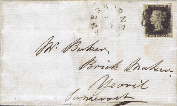
An envelope, posted from Sherborne to Yeovil on 19 May 1841 (using a Penny Black stamp of 1840) addressed simply to Mr Baker, Brick Maker, Yeovil, Somerset. This was William Baker. This envelope was catalogued at £3,500.
From my
collection
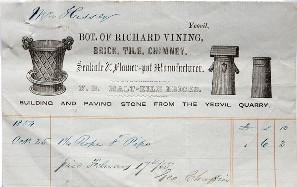
Invoice of Richard Vining (2) dated 25 October 1854. Richard Vining was a brick, tile, chimney, seakale and flower pot manufacturer who also made malt kiln bricks and could supply building and paving stone from the Yeovil Quarry. He was listed in trade directories between 1840 and 1861 but committed suicide by drowning.
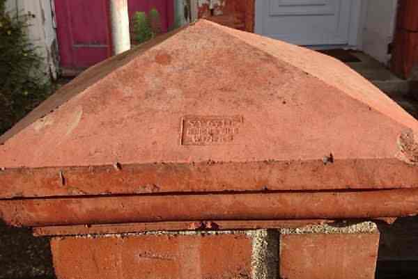
A cap for a brick pier made by the Yeovil Brick & Tile Works (see 13 above) in West Street.
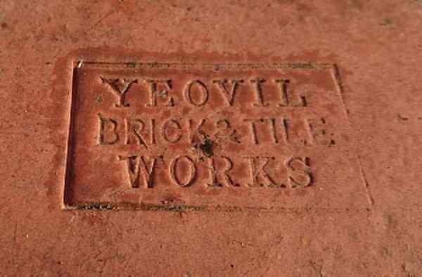
A close up of the Brick & Tile works logo impressed into the above pier cap.
From my
collection
-
This
photograph
features in my
books 'Yeovil From Old Photographs'
and
'Secret Yeovil'.
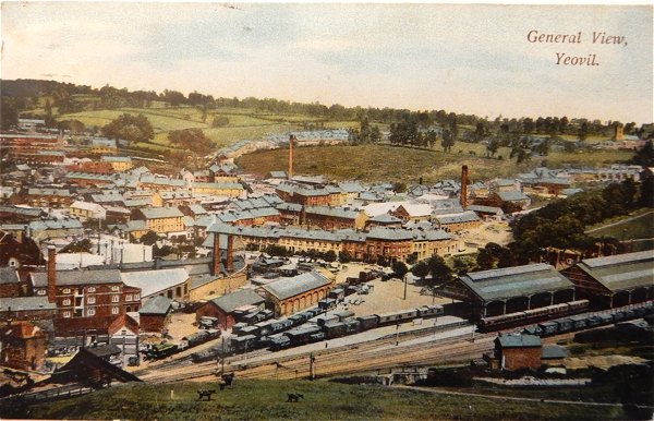
This postcard dates to about 1905 and shows, at centre, the chimney of the Yeovil Brickfields Co Ltd on the southeast corner of Eastland Road with its associated buildings clustered around its base. To its left is the leather works built by William Bide (recogniseable by the double roof with a row of six black windows). Running along the bottom of the photograph is Station Road with the Alexandra Hotel at bottom right. In the top half of the photo, Eastland Road runs behind the chimney with fields either side!!!
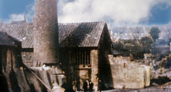
A colourised photograph of the Yeovil Brickfields Co Ltd's buildings (the full height of the chimney is shown in the first photograph above) at the time of their demolition in 1912.
This
photograph
features in my
book "Lost Yeovil"
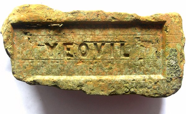
A Yeovil brick. Although damaged It is about 230mm x 100mm x 65mm (9" x 4" x 2½") which is 15mm (½") longer than a modern brick. There is no frog as such (the deep depression in a brick) but the indentation with 'YEOVIL' stamped in it is only about 5mm deep. It is most likely pressed into a mould rather than being hand-made and dates to the late 19th century.
Courtesy of
Brian Murless,
Archivist of the
Somerset
Industrial
Archaeological
Society
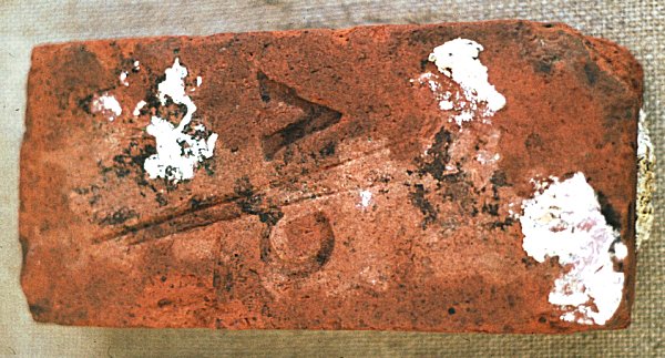
A brick manufactured in Yeovil by Charles Vining and bearing his C/V strike mark. This particular brick came from Hainbury Mill and dates to the 1830s.
This photograph
features in my
book 'Secret Yeovil'.
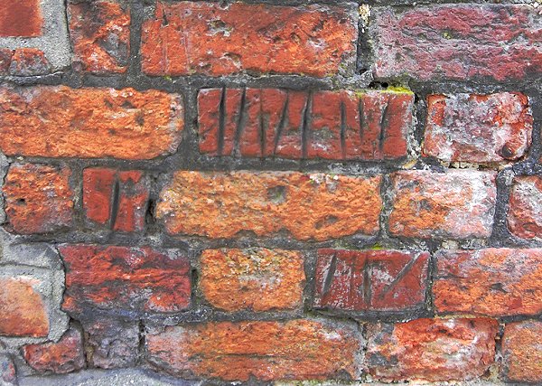
These marks in
the soft Yeovil
red bricks are
at the
South Street
end of
Tabernacle Lane.
The marks were
made by
schoolchildren
sharpening their
slate pencils on
their way to
school in South
Street.