ashgrove
ashgrove
30 Mudford Road
Ashgrove, also known as Ashgrove House, is a substantial five-bedroom Regency-style residence dating to 1839. It was built by Yeovil builder George Harris for 29-year-old Yeovil glove manufacturer and later Mayor of Yeovil, Elias Whitby the Younger (1810-1880) for £500 (mortgaged to tea dealer Silas Feaver - around £62,000 at today's value). The house is set in once-extensive grounds on the northern corner of the junction of Sparrow Lane (now Sparrow Road) with Mudford Road.
Ashgrove was built, as Madeley's map of 1831 shows, in a large empty field (later subdivided) and described as a "Close of Pasture, known as Penny's Ground" after its owner Henry Penny (see Documentation). Ashgrove is clearly shown on the Tithe Map of 1842 as Parcel 1064 (see Maps). The 1846 Tithe Apportionment noted that the owner / occupier at this time was glove manufacturer Elias Whitby the Younger.
Ashgrove is of two storeys (plus cellar) and three bays with colour-washed render scribed with course lines under a hipped Welsh slate roof with wide overhanging eaves. There is a projecting central porch with Roman Doric unfluted columns and flat pilasters carrying a full entablature with a flat roof. Fenestration comprises 12-pane sash windows to the ground floor and 9-pane sashes to the first floor.
In the 1851 census, Elias Whitby gave his occupation as gloving master. He, his wife Hannah and ten of their children were listed living at Green Quarry - although this was almost certainly Ashgrove.
 |
|
In the 1851 census, at the age of 21, Martha Softley was lodging in the boarding house of Mary Lukins in Kingston and listed her occupation as a schoolmistress. Indeed, it was in 1851 that Martha started her own school, later to become The Park School, at Ashgrove. In the 1861 census, Martha was listed at Ashgrove as 'Principal of School' with her sister Harriett and cousin Catherine, known as Kate, both listed as 'Assistant in School'. There were three boarding students; Fanny and Mary Stone, aged 9 and 5 respectively and 7-year old Ellen Indoe. There was capacity for eight boarding students, housed in two bedrooms on the first floor. Also in the house was a boarder, a cook and a housemaid. Shortly after founding her school at Ashgrove, she moved to a house on the corner of Mudford Road and Higher Kingston. However, certainly by 1869, the school was in Park Road since this is the address given in an advertisement announcing the commencement of the new term. |
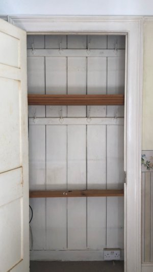
The photograph above shows the inside of a cupboard, in one of the bedrooms referred to above. Of interest, are the two sets of coat hooks one set for daywear for each girl, with a shelf below, and the other set for Sunday best, for the four girls intended to share this bedroom.
In 1854, Elias Whitby Jnr sold Ashgrove to his son, Joseph Whitby (2). Although he lived at Ashgrove in his childhood, Joseph didn't live here after his marriage and in the 1861 census Joseph was listed at Church House with his wife Eleanor.
In 1857, Joseph Whitby sold Ashgrove to draper and pawnbroker James Edwards. In his will, James Edwards left Ashgrove to his son-in-law Elias Lyndall Whitby and on 9 January 1859, James Edwards died. Although Elias Lyndall Whitby owned Ashgrove until his death in 1911, he never lived at Ashgrove - although for many hears he lived in Holcote House, just up the road.
The 1871 census for Mudford Road is somewhat confusing with almost all properties being listed as "cottage". However, one property is listed as a "Private House" occupied by 70 -year-old bachelor Henry Cole, a "Professor of Music"
In 1891, Ashgrove was the residence of Congregational Minister Samuel Allen, his wife Mary, son Herbert and a domestic servant. By 1901 it was the home of Henry Monk who, with his daughter Edith, ran the Grammar School in Flowers House in Hendford. Kelly's Directory of 1919 listed Ashgrove as the residence of Henry James Foote.
The building survives but its plot was divided and the former rear gardens now contain a small, four-storey block of flats, Blackdown House.
maps & AERIAL PHOTOGRAPH
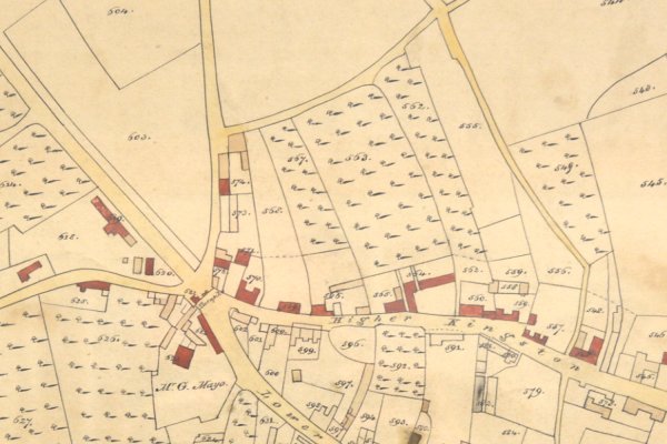
This section of Edward Bullock Watts' 1831 map of Yeovil shows Fiveways at the left, with Mudford Road running straight to the top and, at the right, is Goldcroft. Sparrow Road runs across the top, connecting the two. What appears to be an empty triangular field at top centre, was Penny's Ground. The field would, during the next ten years, be subdivided and Ashgrove would be built in the southwest corner plot.
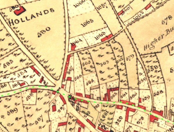
The 1842 Tithe Map, also by Edward Bullock Watts, showing Fiveways towards bottom right and Sparrow Lane coming in from top centre right. Ashgrove is shown as parcel 1064 left of centre.
This map, based
on the 1886
Ordnance Survey,
shows Ashgrove
with its
extensive
landscaped
grounds at
centre, on the
corner of
Mudford Road
(running
vertically left
of centre) and
Sparrow Lane
(now Sparrow
Road) running
off to the
right.
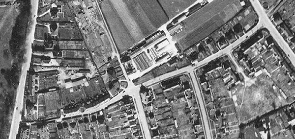
An aerial photograph of 1946 showing Sparrow Road running across the photograph from Mudford Road at left to Goldcroft at right. The two roads at the bottom of the photograph are Roping Road at left of centre and Mitchelmore Road at right of centre. Ashgrove is at the bottom left corner of the photograph.
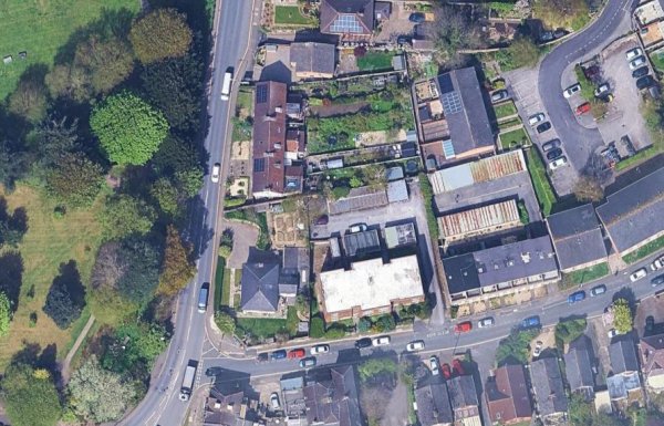
The modern aerial view (courtesy of Mr Google) shows Ashgrove in its much-reduced setting.
gallery
Courtesy of
David Perry
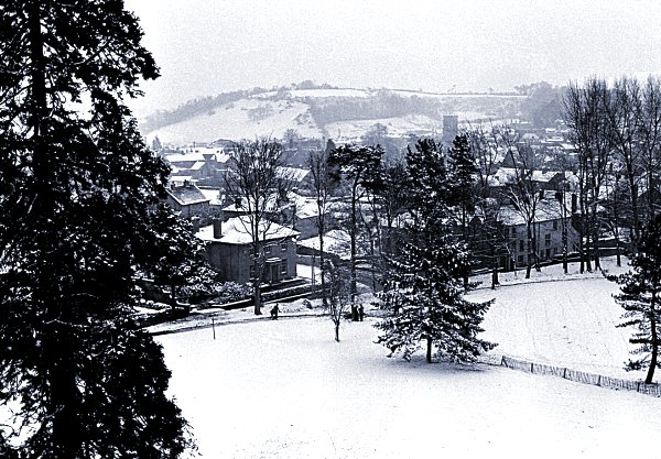
Ashgrove, just left of centre, seen from the top floor of the Yeovil College building during the snows of early 1963.

This
photograph
features in my
book 'Yeovil From Old Photographs'.
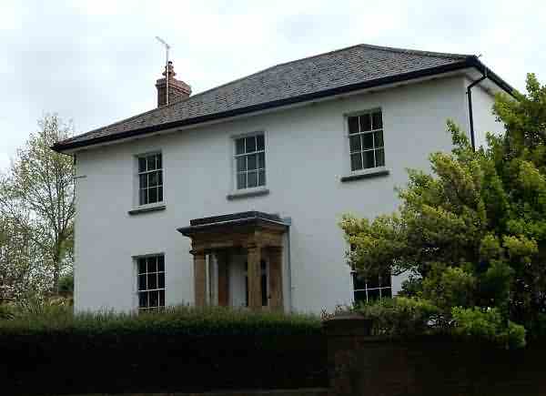
Ashgrove, photographed in the 1970s.
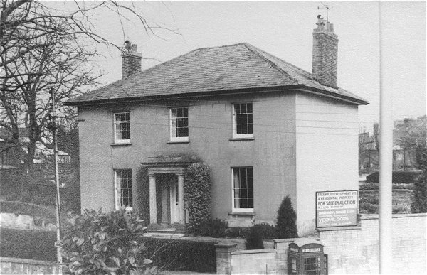
.... and seen from the other direction - for sale by auction by Palmer Snell & Co in two lots; a freehold development and a residential property.
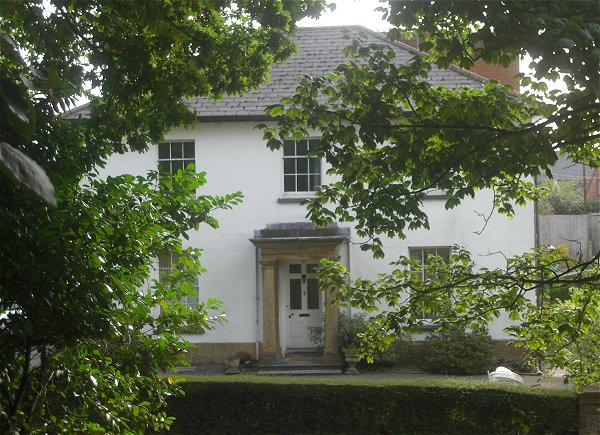
Ashgrove, glimpsed through the trees of Yeovil College campus. Photographed in 2013.
This photograph
features in my
book "Yeovil
In 50 Buildings"
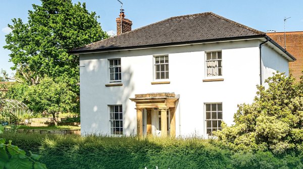
.... and photographed in 2017.
ashgrove today
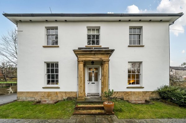
Below are a few photographs of Ashgrove today, taken from a recent sale catalogue. The house is currently (2026) on the market.
Ashgrove, seen from Mudford Road.
... and seen from the front garden.
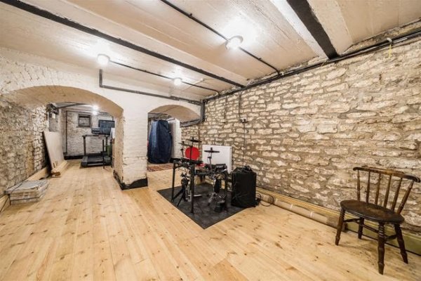
The cellar has been converted to a gym/music room.
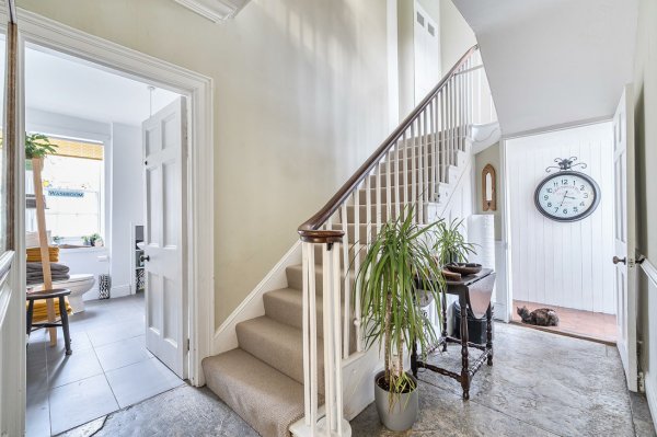
The reception hall.
The lounge / dining room, looking west.
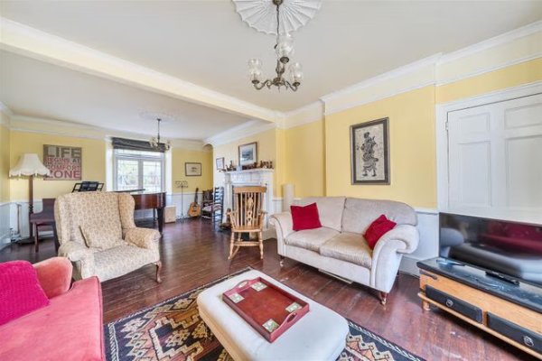
The lounge / dining room, looking east.
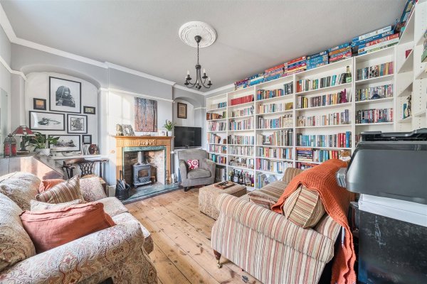
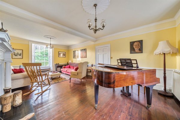
The sitting room / library.
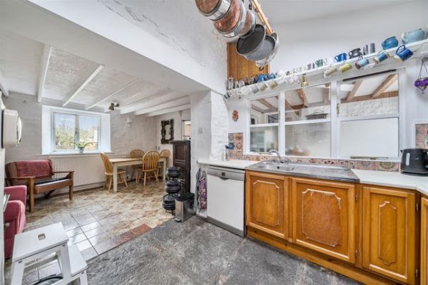
The kitchen / breakfast room.
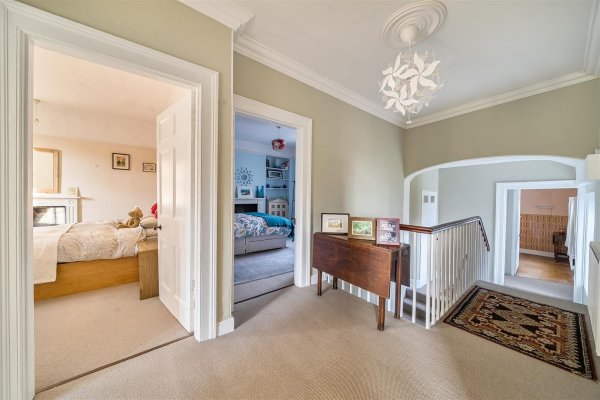
The first floor landing.
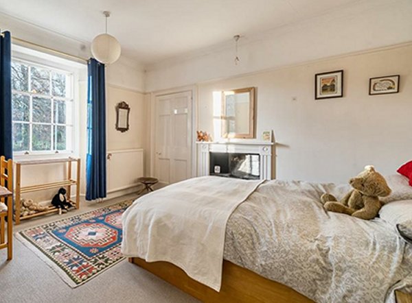
One of the five bedrooms.
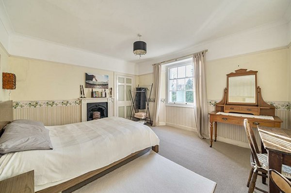
Another of the five bedrooms.
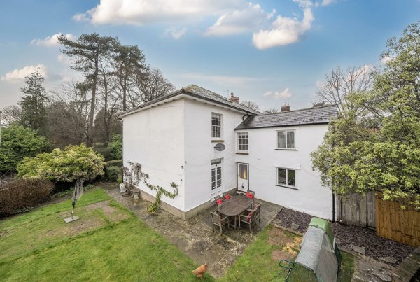
The rarely-seen rear of Ashgrove.
owners, tenants and events of Penny's Ground and Ashgrove
| Date | Owner / Event | Purchaser / Occupier |
| 1818 | George Daniell | Henry Penny |
| 1838 | Henry Penny | John Moody |
| 1839 | John Moody & Trustee | George Harris |
| 1839 | George Harris | Subdivision of Penny's Ground |
| 1839 | Silas Feaver mortgage of £500 to | Elias Whitby Jnr |
| 1839 | Ashgrove built | by George Harris |
| 1840 | George Harris | John Noake Highmore buys the rest of Penny's Ground |
| 1839 - 1851 | Ashgrove occupied by Elias Whitby Jnr | Moves to Kingston House by 1851 |
| 1851 | Elias Whitby Jnr | Martha Softley rents Ashgrove for her school |
| 1854 | Elias Whitby Jnr | Joseph Whitby (tenant) |
| 1857 | Joseph Whitby & Silas Feaver | James Edwards |
| from 1857 | James Edwards | |
| 9 Jan 1859 | Death of James Edwards | Elias Lyndall Whitby (son in law of Edwards, inherited) |
| 1861 | Elias Lyndall Whitby | Joseph Whitby (tenant) |
| 1891 | Elias Lyndall Whitby | Rev Samuel Allen (tenant) |
| 1901 | Elias Lyndall Whitby | Henry Monk (tenant) |
| 1920 | Trustees of Elias Lyndall Whitby | The Reverend Arthur William Gummer Butt |
| 1924 | The Reverend Arthur Gummer Butt | Mrs Maud Adams (died 1925) |
Documentation
-
1818 - Contract for land at Sparrow's Lane (Dated 31 December 1818)
Between George Daniell Esquire and Mr Henry Penny -
1838 - Declaration of George Ewens (Dated 13 October 1838)
Respecting the possession of Penny’s Ground sold by Mr Penny to Mr Moody -
1838 - Henry Penny agreement to produce Marriage Settlement (Dated 24 Dec 1838)
In respect of Penny's Ground -
1839 - John & Edmund Moody to George Harris - Lease for a Year (Dated 24 June 1839)
In respect of Penny's Ground (part of which was later Ashgrove) -
1839 - John & Edmund Moody to George Harris - Conveyance (Dated 25 June 1839)
In respect of Penny's Ground (part of which was later Ashgrove) -
1839 - George Harris to Elias Whitby Jnr (Dated 10 August 1839)
Indenture of Appointment & Release for Ashgrove -
1839 - Deed of Covenant (Dated 10 August 1839)
George Harris to Elias Whitby the younger for Ashgrove -
1839 - Mortgage for £500 and Interest (Dated 20 August 1839)
Silas Feaver to Elias Whitby the younger for Ashgrove -
1852 - Release in Fee of half acre of arable land (Dated 31 January 1852)
Heir of A'Court Daniell & Trustee to George Harris & Elias Whitby Jnr for Ashgrove -
1854 - Conveyance from Elias Whitby Jnr to Joseph Whitby (Dated 25 March 1854)
For Ashgrove -
1857 - Contract between Joseph Whitby and James Edwards (Dated 13 April 1857)
For Ashgrove -
1857 - Conveyance from Silas Feaver and Joseph Whitby to James Edwards
(Dated 21 August 1857)
For Ashgrove -
1857 - Deed of Covenant, George Harris and James Edwards (Dated 21 August 1857)
For Ashgrove title deed -
1920 - Abstract of Title
of James Shorland Aplin and Edward Bailey for Ashgrove -
1920 - Conveyance of Ashgrove House (Dated 6 July 1920)
By Trustees of James Edwards to Rev AW Gummer Butt -
1924 - Conveyance of Ashgrove House (Dated 7 January 1924)
From Rev Arthur William Gummer Butt to Maud Adams