SUMMER Exhibition 2024
Summer Exhibition 2024 - presented by Yeovil's Virtual Museum
Colouring Yeovil
The use of AI in colouring old monochrome photos of Yeovil
![]()
Introduction
Today we take colour photography for granted. Taking pictures in full, natural colour is so easy that we rarely stop to consider how it all came about. In 1839, when photographs were seen for the very first time, they were greeted with a sense of wonder. However, this amazement was soon mixed with disappointment. People didn’t understand how a process that could record all aspects of a scene with such fine detail could fail to record its colours.
The basis of all practical colour photographic processes, the three-colour method, was first suggested in 1855 by Scottish physicist James Clerk Maxwell, with the first colour photograph being produced by Thomas Sutton for a Maxwell lecture in 1861.
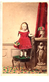 In
mid-Victorian
times, several
different
processes and
materials were
used for
hand-colouring
photographs,
which proved to
be a far cheaper,
simpler
alternative to
early colour
photographic processes. It
provided studio
employment for
miniature
painters who had
initially felt
threatened by
the emergence of
photography.
For example
John Chaffin, of
Hendford,
employed his two
daughters to
colour his
photographic
prints as an
expensive
'deluxe' option,
as well as
reproducing
photographs in
oil on canvas.
Chaffin's
daughters, Kate
and Maria, aged
20 and 19, were
both listed as
artists at
Chaffin's
photographic
studio in the
1871 census.
(The example of
a hand-coloured
photograph at
left is not by a
Yeovil
artist).
However, it wasn't until the 1970s that color photography became the dominant form of photography, with monochrome photography mostly relegated to niche markets such as art photography.
Monochrome images which have been 'colourised' by tinting selected areas either by hand, mechanically or with the aid of a computer are 'coloured photographs', not 'colour photographs'. Their colors are not dependent on the actual colors of the objects photographed and may be inaccurate.
Nevertheless, most people prefer an image in colour to the same image in monochrome. So, a few years ago I began experimenting with computerised colourising of some of my old black and white photographs of Yeovil for inclusion in Yeovil's Virtual Museum to enhance the viewing experience. Admittedly, the results were somewhat variable at that time.
In January 2024, aware of advances made in artificial intelligence (AI), I began experimenting again. The results this time around were much more successful, and this exhibition is the result. To date, of the 13,650 images in Yeovil's Virtual Museum, I have colourised between seven and eight hundred monochrome photographs. From the feedback I receive, the results appear to be appreciated by the vast majority of people.
![]()
The Techie Bit

Neither system is perfect, but with a bit of 'fiddling' I can usually get an acceptable, if not excellent, image. Palette offers some twenty different 'styles' with previews, although I generally only use one of three styles. The main problem with Palette is that it rarely sees grass as green, so it is not often useful for photos including areas of grass - although there are several excellent examples below. Other than that, it is quite good. I paid to colourise up to 500 images at high resolution that I keep alongside the originals for posterity (all my collections are willed to the South Somerset Heritage Collection). These are not necessary for the smaller images used in Yeovil's Virtual Museum, for which I use the free service. Both Palette and inPixio make very heavy use of computer resources, such that after using for an hour, my graphics computer (which has 16Gb of RAM) usually grinds to a halt and has to be restarted.
Below, are four images of the same view to illustrate the steps I usually follow to produce a colourised image from a monochrome original.

Image 'a'
is the original image. It is usually necessary to convert sepia-toned or simply old, faded images to greyscale and I often darken the image to further bring out the detail - as seen in image 'b'. This greyscale image is then used in Palette to produce the colourised image 'c'. Sometimes it is enough to stop at this stage if, for example, the original image has detail in the sky or no sky is in the image. Image 'd' has had one of my Yeovil skies added using inPixio.
![]()
The Exhibition
The images shown here are in chronological order - each has a small monochrome image of the original photograph set within it. The quality of the very early images often leaves a lot to be desired, such that the finished colourised images are often only just acceptable, but at least offer an idea of a colourised original.
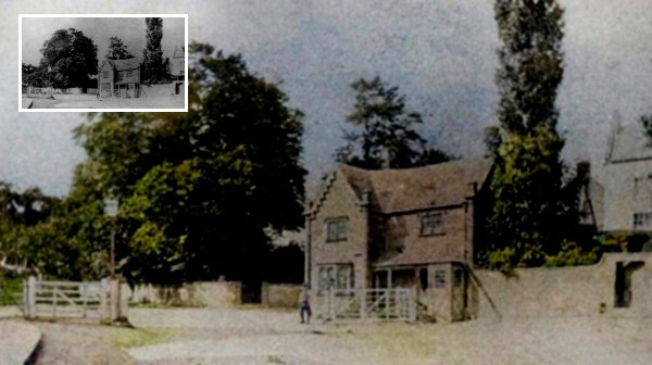
The original photograph features in my book 'Yeovil From Old Photographs'.
Kingston Turnpike House photographed about 1860 by Henry Goodfellow. Notice the gates which would close until tolls had been paid. The house was moved a hundred yards further down Kingston in 1875.

Original
photograph courtesy of Mrs
M J Rogers
Under Bow, in the Borough, on the corner of Grope Lane (today's Wine Street), photographed in 1861 by artist and photographer Frederick Treble. It is one half of a stereoscopic pair of images.
Under Bow was an old house, described as 'ancient' and 'typical of many former houses in the town'. It possibly dated to the sixteenth century, if not earlier. It had an overhanging front to the first floor, featuring an oriel window at first floor, supported by two columns. Ruined by fire, it was demolished in the 1860s and caused a stir amongst Yeovilians similar to the destruction of the George in the 1960's.
At far left is probably the first photograph of the Wine Street elevation of the newly-built Medical Hall, and at the right is an early photograph of the building that was part of Josiah Hannam's ironmongery and, later, William Maynard's Borough Restaurant.

I know that this photograph was taken in 1864 at Brympton d'Evercy, but sadly I have no further information on the ladies in the carriage.

From my
collection. The
original
photograph
features in my
book "Lost Yeovil"
The Borough seen from High Street in an early photograph dating to about 1865 by W Barratt of Bridport. Note the buildings either side of Middle Street - London House to the left and the Medical Hall to the right. The blur in the bottom left corner was caused by a pedestrian moving during the long exposure required.
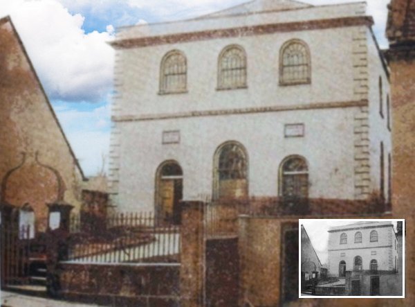
The original photograph
features in my
books 'Yeovil
From Old
Photographs'
and
"Yeovil
In 50 Buildings"
A photograph of the Baptist Chapel in South Street taken before 1867 (the porch was added in 1868). Note the front elevation is completely different to the present elevation (see below), note too the absence of the Newnam Hall, built in 1912 at the left.

From my
collection
This carte de visite is, I believe, the only known photograph of the Town Hall in High Street with its original clock tower. It was taken by Yeovil photographer John Chaffin and, from the style of the back of the CDV and other subtle clues in the photograph, was taken in early 1868, when he was working alone and before his son Thomas became a partner in the business that became Chaffin & Son in 1869. The clock tower seen here was declared unsafe in 1887, and was dismantled that same year.
A new steel-framed clock tower was erected in 1912, designed to evenly distribute the great weight of the clock tower, its gas-illuminated clock and the heavy bells. Comparing this first clock tower with the later version, it would appear that the later tower's design was based on that of the former, although there are very minor differences.

The original photograph
features in my
book 'Yeovil
From Old
Photographs'
This remarkable photograph was taken in November 1861 and looks north along Kingston as seen from just outside what would become Bide's Gardens. Towards the left is Pitney Villa with its impressive set of double steps. To its right is Pitney House. The small grocer's shop at left is that of JT Foole who had recently taken the shop over from Gerard Samson.

This photograph of Princes Street dates to around 1875 and is one half of a stereoscopic pair. It was taken from the junction with High Street and looks north. At the time Henry Marsh Custard was running his bookshop / printer's / stationers which was situated in the three-storey building to the left of the cart in the photograph. The narrow lane seen between Custard's building and the building at extreme left was colloquially known as Custard's Lane and later widened to become Westminster Street. The imposing building at right, once a private residence known as Mayfair, was the hairdressing salon of Frank Gaylard, and home to the 'Yeovil & District Toilet Club', between the 1870s and 1920s. The two-storey building at extreme right, on the corner of Princes Street and High Street, was the home and furniture shop of Henry White. Between Gaylard's and the rear entrance to the Mermaid Hotel was, for decades, the premises of the Plowman family of harness and saddle makers.

Taken before 1879, this photograph by Adam Gosney shows the Greyhound Hotel at extreme right (before being rebuilt in its present form), the Cow Inn next door, the Globe and Crown opposite and the Three Choughs Hotel in the far distance at the end of South Street. Between the Cow Inn and the Choughs was the two-storey King's Arms (2) in the far distance as well as a couple of un-named beerhouses. Then the three-storey Market House Inn and then another un-named beerhouse. Just think, what an ideal pub crawl - unlike today as all these hostelries are long gone. Note the horse-drawn omnibus parked outside the Greyhound.
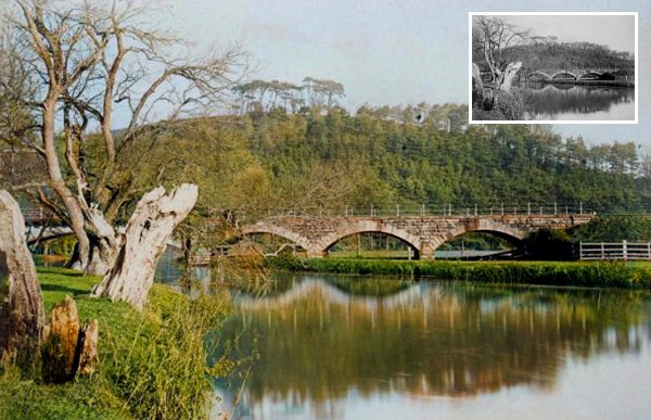
Original
photograph from the
Stiby
Collection,
Courtesy of South Somerset Heritage Collection
Wyndham Hill photographed around 1885 by Henry Stiby. 25 trees were planted on the hill to celebrate Queen Victoria's Silver Jubilee in 1862. The railway bridge is long gone.

Original
photograph from the
Stiby
Collection,
Courtesy of South Somerset Heritage Collection
The original of
this photograph
features in my
book 'Yeovil
From Old
Photographs'
A photograph by Henry Stiby, dating to the 1880s, showing Yeovil Bridge and the toll house. The River Yeo is the boundary between Somerset and Dorset and is the eastern end of Sherborne Road before becoming the dual carriageway of Babylon Hill.

Original
photograph from the
Stiby
Collection,
Courtesy of South Somerset Heritage Collection
The site of or, more likely, the building of the George Inn by this time housing Denner & Stiby's shop. Photographed in 1883, by Henry Stiby who was a keen amateur photographer and left a good record of photographs of Yeovil. Note under the right of the three first floor windows, is the entrance to the less-than-savoury George Court (see below).

The original photograph
features in my
book 'Yeovil
From Old
Photographs'
The salt-house, at left, from where the name Salthouse Lane derives with the cottages of Spring Gardens at right. Photographed after 1886 (after the corner section had been demolished) and seen from Huish with Salthouse Lane running off to the right. The Spring Gardens cottages were demolished in 1955 and it is likely that the Salthouse was demolished at the same time.

Original
photograph from the
Stiby
Collection,
Courtesy of South Somerset Heritage Collection
The newly-rebuilt St John's schoolrooms photographed around 1897 by Henry Stiby. Note the fence around the churchyard, originally intended to keep dogs out of the church.

Of course before there were motorised charabancs, there were still staff outings. This photograph of around 1890, shows staff of Whitby Brothers glove manufactory on a day out to Batcombe Down in the horse-drawn version of a charabanc.

The southern end of Princes Street, in a photograph of around 1895. Very few of the buildings have changed except that at the very left edge, which was removed around 1919 for the creation of Westminster Street.

From my
collection.
The
original image
features in my
book 'Yeovil
- The Postcard
Collection'.
This postcard by William Beale Collins dates to about 1900. At extreme left is just seen the edge of Lindsay Denner's shop and next to it are the remaining shops before he took them over. The two men at centre are standing outside Stuckey's Bank (demolished before 1918) and between the bank building and Genge's shop is the narrow entrance to Porter's Lane (later widened to become today's Westminster Street). William Beale Collin's own printing and bookselling premises are seen at extreme right.

From my
collection
-
The original
image
features in my
book 'Yeovil
From Old
Photographs'
This photograph is taken from a postcard. Note the horse-drawn omnibus - the Mermaid Hotel had its own omnibus that ran to and from the railway stations as a courtesy to guests.

From my
collection
- The
original
photograph
features in my
book 'Yeovil
From Old
Photographs'
A postcard from at least 1905 (but this one posted in 1907) with the Three Coughs Hotel's own horse-drawn carriages used to transport guests to and from the railway stations. The hotel had extensive livery stables and coach houses - diagonally opposite the hotel and located at the junction of Hendford and West Hendford.

This photograph of William Maynard's Borough Restaurant, dates to about 1907, by which time Maynard had relinquished that part of his shop adjoining Wine Street to the left. It was now occupied by Edwin Seddon, jeweller and watchmaker who installed the clock in the Western Gazette offices in 1906.

The
original photograph
features in my
book "Lost Yeovil"
This photograph, taken around 1910 before Health & Safety had been thought of, is of Hayne's butcher's shop in the Borough (literally) - the shop was in the white building behind the War Memorial, between the Borough and the churchyard. Hayne's moved to their current premises at the very northern end of Princes Street in 1939, where it remains today.

The Harris family of Victoria Place, Clarence Street. A lifelong spinster, Louisa (second from left of the five girls) was confined to a wheelchair throughout her life. Nevertheless, she kept a journal from 1886 until 1926 and, although much of it relates to the illnesses endured by what comes across as a very sickly family, it is an important record of life in Yeovil during this time.
Many extracts from Louisa's journals, from 1887 through to 1911, are included in Yeovil's Virtual Museum. For a list of extracts - click here.

From my
collection.
The
original
image
features in my
book 'Yeovil
- The Postcard
Collection'.
This photograph of High Street, from around 1910, gives a really good indication of just how large Sugg lamps were. Nice to see that even before my time, lads used to hang around on street corners. Mind you, I don't think that even if I was around in 1910 I would have worn a boater and plus fours, let alone sport a cane.

From my
collection
-
The
original photograph
features in my
book 'Yeovil From Old Photographs'.
A postcard of about 1910 by which time Kingston School had been renamed the County School. Believe it or not, at the far end of Kingston is a man riding a horse down the road.

The original photograph
features in my
book 'Yeovil
From Old
Photographs'
A photograph of the imposing frontage of the Assembly Rooms in Princes Street of about 1910. The grand building that was home to the Princes Street Constitutional Club, was built in 1888 and opened the following year. The Assembly Rooms was the first venue in Yeovil to show films - black and white one-reelers - from 1896 when Yeovil's first film license was granted.

The
original photograph
features in my
book 'Yeovil From Old Photographs'.
This photograph of about 1910, shows the Market House Inn in its South Street setting. The Market House Inn is the three-storied building to left of centre. The two-storied building to its left is the Cheese Market building with its three arches at ground floor level. Between the two buildings is the entrance to George Court (see below). To the right of the Market House Inn was an un-named beerhouse. At far left the three- and two-storey buildings are the Three Choughs Hotel and next to it the King's Arms 2.

From my
collection
An unknown local football team of the 1911-12 season.

The original
image is from the Cave
Collection,
Courtesy of South Somerset Heritage Collection
High Street decorated to celebrate the coronation of King George V on 22 June 1911. Everyone got the day off and paraded around the town, like these fashionable ladies and girls (the younger the lady, the shorter the hem on her coat/dress).

Also celebrating the coronation of King George V, children parade through the Borough on their way to the Coronation Sports Day held at Wyndham Fields.
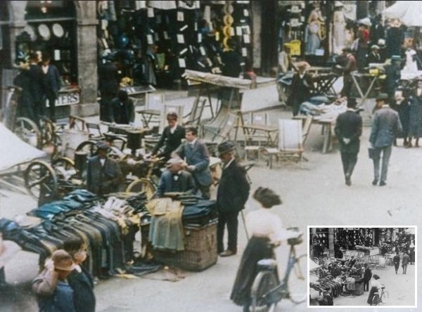
Yeovil's weekly market in the Borough in a photograph of about 1912.

The original
photograph
features in my
book 'Yeovil From Old Photographs'.
This postcard of 1912 looks up Hendford Hill. At left is the Railway Hotel, beyond which is Aldon Terrace. The Hendford Supply Stores was run by George Maidment from the late 1870s until his death in 1909.

Crowds gather as the Right Hon John Burns MP, officially opens Yeovil's first council house in Southville, in this photograph of Saturday 2 November 1912.

This photograph of Silver Street, taken from the Borough, was by J Slade and published as a postcard in 1913. At the extreme right side, with the awning, is London House which was demolished in 1913 and the present building built for the Midland Bank opened in 1914. The photograph features a single-light Sugg lamp at the centre.

A photograph of around 1913 showing the blacksmith shop of Petters Ltd in the Nautilus Works on the corner of Goldcroft and Reckleford.
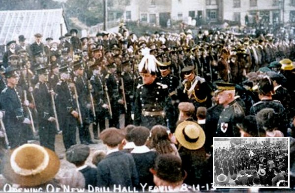
This photograph, by Frederick Christopher, shows the ceremony of opening the new Drill Hall in Southville on 8 November 1913, photographed from Southville looking across to Reckleford. .

Original
photograph courtesy of John
Green
The construction of Petters Ltd's new foundry at the Westland site, in a photograph of 1913.

Original
photograph courtesy of
Chris Priddle
The Yeovil Police tug-o-war team, photographed outside the Town House in 1914. They proudly display the cup they won in a competition at Taunton, sitting on top of the tug-o-war rope. Only people known in this photo are Sgt Harry Coats - front row at left - and next to him is Sgt Alfred Edward Brooks.

From my
collection
High Street in a photograph of around 1914, with Stuckey's Bank in the background.

Volunteers for Kitchener's army march down Lower Middle Street in September 1914, on their way to the Town Railway Station, accompanied by a local band and crowds of onlookers.

War Horses. The day after war was declared against Germany, a Government inspector travelled to Yeovil to commandeer horses for use by the army. It has been estimated that the number of horses that served in the First World War was around six million, with a large percentage of them dying due to war-related causes - the remainder were mostly left behind to feed starving French and Belgian civilians. In 1914, estimates put Britain's horse population at between 20,000 and 25,000 and as well as requisitioning from British civilians, in order to meet its need for horses, Britain imported them from Australia, Canada, the USA, and Argentina.

This photograph of about 1915, shows the former George Inn, or at least its site, at centre, with the former Bell Inn, at left, set well back from High Street. By the time of this photograph the building was called Borough House and was used as municipal offices. The tree and shop at centre are in the position of where King George Street now joins High Street and the tall building at right is the old Town Hall (built in 1849) with its tower and gas-illuminated clock, installed in 1912. The Town Hall was destroyed in 1935 by a fire believed to have been caused by paper rubbish blowing into the tower and ignited by the gas jets illuminating the clock.
The port cochère just glimpsed behind the cart, was the entrance to George Court (see next).

The
original photograph
features in my
book 'Secret Yeovil'.
This photograph dates to about 1915 and looks north along George Court - described in 1846 as "a great nuisance" - towards High Street with the meat market at left and slum housing at right. At the end, the 'flying freehold' is built over the port cochère mentioned above - the tiny entrance to George Court. To the right the Court widens towards the Bell Inn or, as was called in 1886, the Borough Hotel.

The
original photograph
features in my
book 'Secret Yeovil'.
Also dating to about 1915, this photograph looks south along George Court towards South Street and the widening of the Court is now at left. The buildings at the far end are the Newnam Memorial Hall and the Baptist church on the other side of South Street.

High Street photographed in 1918. Note the triple-light Sugg lamp, the Mermaid's horse-drawn omnibus in the distance and also that the market was held here in the street.

The original photograph
features in my
book 'Yeovil From Old Photographs'.
By 1918, the date of this Walter Rendell photograph, the former Western Gazette offices were being used as a Salvation Army Temple. Note the gas holder dominating the view into town.

One of the four Barwick Park Follies, the Rose Tower features in a postcard of the 1920s.

The Portreeve's Almshouse, later known as the Corporation Almshouse, burnt down in 1910. A new site was chosen in Preston Grove where Dorcas House, the new Corporation Almshouse, was built. The photograph was probably taken by Henry Stiby, who was heavily involved with the new building, was a generous subscriber, with others, to the building fund and laid the foundation stone on 27 July 1910.

The original photograph
features in my
book "Lost Yeovil"
This photograph of 1924 is of Blake & Fox's leather dressing yard where the men are working at the soaking and lime pits.

The table glove cutting shop of glove manufacturers Atherton & Clothier of Court Ash, in a photograph of the 1920s.

A postcard from the 1920s (postmarked June 1930), showing the new General Hospital as seen from Bide's Gardens. The hospital was extended to the right during the 1940s.

The north side of Lower Middle Street, close to the Triangle, probably a photograph of 1923 (when Mary Slann was running the Coronation Hotel a few doors along). Since this stretch of road from London Road (today's Sherborne Road) to the Triangle was the road leading to the town, or the fore-way, it was known as Fore Street from medieval times.

The southern end of Princes Street in a photograph of the mid-1920s - little changed today. Princes Street at this time had two-way traffic.

Original
photograph from the
Stiby
Collection,
Courtesy of South Somerset Heritage Collection
A photograph by former Mayor of Yeovil, Henry Stiby, showing the laying of the foundation stone of the new municipal offices in King George Street being laid on 19 July 1926, by the then Mayor of Yeovil, Alderman Percy Petter.

Courtesy of
Brian Kersting
The Black Horse Inn, Reckleford, in a photograph of around 1926 - before being rebuilt as we see it today. This building was built between 1842 and 1886 on the site of an earlier pub of the same name.

From my
collection
- The
original image
features in my
book 'Yeovil
From Old
Photographs'
A postcard of 1927 with the completed toilets in front of the Co-op building with the Palace Theatre seen at extreme left.

From my
collection
The original postcard dated 1929, looks across the Borough towards King George Street. King George Street had recently opened and Frederick Taylor's store (seen behind the car) is only two storeys high at this time.

The original
photograph
features in my
book 'Yeovil From Old Photographs'.
A photograph of the western end of Vicarage Street in the 1930s. At centre, just to the left of the bus, is the Unitarian Chapel.

Courtesy of
Michael Wilcox
This photograph, showing the interior of Hill, Sawtell & Co's shop (today's Superdrug building), was taken by Harold Tilzey and is from an album dated July 1940.

Late in the evening of Good Friday 11 April 1941, several delay-action bombs were dropped by the Luftwaffe on the town centre with one completely destroying the old Medical Hall in the Borough, the premises of Boots the Chemist. Immediately after the war the site was cleared and an ornamental garden was laid out, seen here, planted with tulips and other flowers donated by Dutch children who had been evacuated to Yeovil during the Second World War. Boots rebuilt on the site and the present building (now Burger King) dates to 1956.

The Bide's Gardens Howitzer was a captured First World War German howitzer given to the Borough Council by the War Office Trophies Committee and originally sited on a concrete plinth in the Triangle. It was moved to Bide's Gardens in 1922 where it remained until it was taken away after the Second World War. This photograph, of around 1950, shows the location of the howitzer in relation to Court Ash and Princes Street.

During the night of Saturday 24 / Sunday 25 May 1930 a devastating fire broke out in the Central Auction Rooms in Church Street. Rebuilt as the Central Cinema, it opened in January 1932. Designed in an art deco neo-Egyptian style by Douglas Langford, an Exeter architect, the new cinema could accommodate 560 patrons. The front elevation was clad in faience tiles and the columns between the top floor windows had lotus bud capitals. The building, colloquially known as the flea pit or the bug house, closed in 1979 and was left to rot. It remained empty and derelict until it was finally demolished, despite protests, in January 1983.

Church Terrace is a terrace of houses, now all offices, dating to the late 1830's, approached via a flight of stone steps from Silver Street. In its early days, at least until the 1880's, it was known simply as Church Yard. This is a photograph of Church Terrace seen from the churchyard, probably in the 1950s. Notice the first two houses at left, with their Regency portico, are in their natural brick finish, before being rendered and painted. The obelisk tombstone is of 33-year-old Mary Vining, first wife of James Tally Vining who died in childbirth.

The original photograph
features in my
book "Lost Yeovil"
The Yeovil gasworks, off Middle Street, were built by the Yeovil Gas & Coke Company and completed in 1833 on the site of a drained withy bed. Complete with retorts and gas holders, by 1856 it was producing 28,000 cubic feet of gas daily and supplied gas to the Corporation's 124 street lamps. The gasworks closed in 1957 and the site cleared in the early 1970s.

From my
collection. The
original photograph
features in my
book "Lost Yeovil"
In the early 1960s, a horse-drawn ice cream van delivers to newly-built Sandringham Road.

The three gas-fired Sugg lamps were replaced by a single electric light, seen in this colourised photograph, in the mid-1920s and the same happened at the junction of High Street and Princes Street. Since the Co-op is in the old Jesty's building at extreme right this photo must be after about 1954, but because the Coronation Hotel is still standing at extreme left it must be before about 1964.

Queen Street decorated to celebrate the Coronation of Queen Elizabeth II in June 1953.

Looking along the along the 'top' of Hendford to the junction with High Street and Princes Street, this photograph dates to around 1955.

This photograph of 1956, looks west along Preston Road, in Preston Plucknett. The thatched cottages were soon demolished. The large house behind the cottages was Sutherland House, home to Yeovil poet and author Walter Raymond from around 1892 to 1905.

The original
photograph is from the Cave
collection. Courtesy of South Somerset Heritage Collection
Looking across the Triangle, this 1958 photograph looks towards Stars Lane and South Street. The building at right is no longer occupied by the Co-operative Society. Note the malodourous underground lavatories at the left.

The original
image is from the Cave
Collection,
Courtesy of South Somerset Heritage Collection
Almost all the buildings in Park Street were demolished in the very early 1960s. In this photograph of 1959, beyond these terraces of houses, it is seen that demolition has already begun.

The original
image is from the Cave
Collection,
Courtesy of South Somerset Heritage Collection
The George Inn, Middle Street, began life as a private dwelling, built during the 1400’s and from 1478 it was owned (among other licensed premises) by the Trustees of Woborn's Almshouse, who continued to own it until 1920 with the rent of the building providing a regular income for the Almshouse.
The demise of the George, the last remaining secular medieval building in the town, appears to be a sorry tale indeed, although the facts are invariably unknown by most people who decry its passing. That the George was wantonly and summarily destroyed by the council is a widely-held and mostly untrue account of events. In the early 1960’s (so I was told by Jack Sweet, who was a committee clerk at the time and involved with the demise of the George), the brewery wanted rid of the property and there was no interest at all to purchase it from them until Elmo, the supermarket chain, purchased the property. At the same time the Council, in its wisdom, decided that Middle Street needed widening and the demolition of the George would be beneficial as part of the road widening scheme. The pub was, sadly and widely opposed by public opinion, demolished in 1962 as seen in this photograph.

Photographed in the 1960s, this was the old library in the King George Street municipal offices. When I worked in the building during the later 1970s, this was the Engineer's drawing office of the council's Technical Department.

Before Yeovil Town Station was built, a lane known as Coach Lane ran from Newton Road to Dodham. It ran across the site of the proposed station and goods yard and was a public thoroughfare. Coach Lane eventually became known as Gas Lane since it skirted the Town Gas Works. This photograph looks southwest, with the station's goods office at left and rag and metal merchant Johnny Farr's premises in the distance at right. The gas works closed in 1957 and the site cleared in the early 1960s. Gas Lane disappeared with it.

A rainy day in Princes Street during the 1960s, taken from Church Street and looking south. The butchers, W & R Fletcher Ltd, was a New Zealand company with freezing works in Australia as well. They were sending mutton and lamb to the UK in the 1880s and opened cold stores to wholesale to butchers. By 1910 they had 417 shops, mainly in the south of England. Union Cold Storage bought them out in 1912 and used the name W&R Fletcher until the 1960s in Yeovil.

The original
image is from the Cave
Collection,
Courtesy of South Somerset Heritage Collection
Taken from outside the Manor Hotel, this photograph of about 1960 looks north along Hendford. This short parade of shops had earlier been known as 'The Rink' and was Henry White's Furnishing Warehouse. The building was known as 'The Rink' because it had originally been built as a roller skating rink.

The original
image is from the Cave
Collection,
Courtesy of South Somerset Heritage Collection
Hendford Terrace was a row of houses in Hendford situated between Chant’s Path and the Volunteer Inn on the corner of Brunswick Street. The terrace appears on Bidder's map of Yeovil of 1843. The terrace was finally demolished for the widening of Hendford around 1965. The site is now the grassy bank opposite the entrance to Hendford Lodge Medical Centre.

The original
image is from the Cave
Collection,
Courtesy of South Somerset Heritage Collection
This photograph, taken in the early 1960's looks down Reckleford Hill from the Avenue / Court Ash Terrace crossroads. The entrance to the Avenue is at left with the sign of the Black Horse evident on the corner. At right is the entrance to Court Ash Terrace - this section of Court Ash was closed a short while after this photograph was taken and the whole area including the top section of Court Ash Terrace as well as all the buildings to the Nags Head was redeveloped as part of the widening of Reckleford.

The original
image is from the Cave
Collection,
Courtesy of South Somerset Heritage Collection
This photograph dates to a rainy day in the mid-1960's and shows Lower Middle Street with Commercial Buildings at centre next to the Railway Tavern (now replaced by the Wetherspoons' pub, the William Dampier) at right. At far right is Central Road and the photograph was taken from Station Road (now called Old Station Road or South Western Terrace).

The original
image is from the Cave
Collection,
Courtesy of South Somerset Heritage Collection
Market stalls left in-situ in what is now the Petters Way car park. Photographed in the 1960's from Petters Way looking towards South Street. South Street House would originally have stretched right across this photograph.

The original
photograph courtesy of
David Perry
A lovely photograph of the Bides Gardens' shelter taken in the mid-1960s, when the hospital's maternity unit was being built in the background.
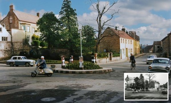
The original
image is from the Cave
Collection,
Courtesy of South Somerset Heritage Collection
Taken from outside the RAFA Club, around 1965, and looking across Fiveways to Mudford Road (at extreme left), Higher Kingston (straight across) and Kingston (off photo at right). At the centre is the original tiny Fiveways roundabout.

The original
image is from the Cave
Collection,
Courtesy of South Somerset Heritage Collection
The photograph above, taken around 1965, looks south down Kingston towards Princes Street and is taken from just about outside the Duke of York. Immediately behind the car at right is the White Lion with its sign visible above the car. At the end of the street, the Red Lion stands in front of the last tree.

The original
image is from the Cave
Collection,
Courtesy of South Somerset Heritage Collection
A photograph of the 1960s, showing the construction of the new fire and ambulance stations on Reckleford. The houses of Salisbury Terrace, at the right, would soon be demolished for the widening of Reckleford. That the widening is already planned at this time is evidenced by the dwarf wall built outside the fire station which, today, is just a path-width away from the dual carriageway.
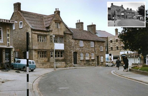
The original
image is from the Cave
Collection,
Courtesy of South Somerset Heritage Collection
Looking back to the double-bend towards the eastern end of Vicarage Street, this photograph shows the Britannia Inn, originally a seventeenth century house, and adjoining cottages taken about 1968. Off-photo to the right is the Methodist church.

The original
image is from the Cave
Collection,
Courtesy of South Somerset Heritage Collection
This photograph, taken about 1965 from the Triangle, shows the entrance to Vicarage Street at centre and the building with the white rectangle is the Britannia Inn of the previous photograph. At left is the old Co-Operative store and offices (currently, 2024, vacant) next is the entrance to Middle Street. Britons shop was earlier Belben's Bazaar, later the Woolwich Building Society and is now a bookmakers. To the right are buildings still existing, at far right is the Coronation Hotel & Vaults - demolished shortly after this photograph was taken - in front of which are the infamous underground toilets.

Original
photograph courtesy of
Chris Symes
The interior of Symes Delicatessen, Princes Street, with Tom Symes serving customers, in a photograph of the 1980s. The Honeycombe and Symes families were Yeovil shopkeepers from the 1890s through to the 1980s.
